
As the smoke lifts, temperatures surge
Minnesota heads into another long heat wave
Go Deeper.
Create an account or log in to save stories.
Like this?
Thanks for liking this story! We have added it to a list of your favorite stories.


The smoke plaguing Minnesota slowly diminishes, but the return of more sunshine allows temperatures to climb again, with hot and predominantly dry weather forecast into August.
Wednesday’s forecast
Although winds are now starting to shift and will start coming from a southerly direction Wednesday, the previous flow from the north much of Monday and part of Tuesday funneled the smoke back in across the state, which will now take a couple of days to dissipate. This means almost the entire state is still under an air quality alert until Thursday morning, and smoke and haze will continue to be a problem Wednesday.

The thickest smoke is expected to be around the Red River Valley area in northwestern Minnesota, especially during the morning.
Morning lows were mostly in the 60s, and highs will be seasonable in the 70s north and 80s south.
Turn Up Your Support
MPR News helps you turn down the noise and build shared understanding. Turn up your support for this public resource and keep trusted journalism accessible to all.
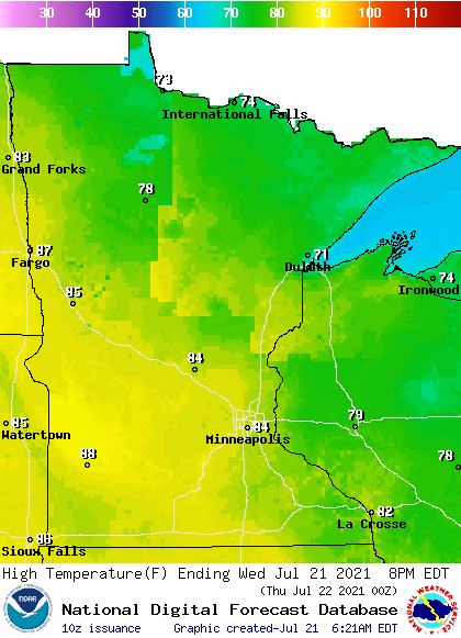
Those are cooler highs than most of the state has seen recently in part because some slightly cooler air moved in when we had winds from the north, and also because there is so much haze blocking the sun it is limiting our afternoon heating.
It will stay muggy though, despite the slightly lower temperatures.
A weak boundary of lower pressure will once again trigger a few spotty showers and storms in the northern half of the state, especially in the afternoon and evening, producing isolated areas of beneficial rain.
Hot weather returns
The winds that turn more southerly by late Wednesday persist Thursday and into much of Friday.

That flow continues to dissipate much of the smoke and haze that made it into Minnesota from the Canadian fires, and already Thursday there will be more sunshine. The sunshine plus a warmer wind flow puts all but northern Minnesota back in the 90s Thursday and almost the entire state in the 90s by Friday.
Here is the Twin Cities forecast through the weekend:

That pattern also continues to raise the humidity, with sticky dew points in the 60s and low 70s by Friday. This could push the heat index past 100 at times by the end of the week.
Hotter weather is also expected to persist next week, with more 90s likely and a couple 100s possible in portions of southern or western Minnesota.
This extended heat wave is currently forecast to carry us through the rest of July and into the beginning of August.
Rain prospects
The state is also likely to stay drier than average, although there will be enough disturbances and instability to keep spotty precipitation chances in the forecast.
Northern Minnesota can expect isolated activity through Thursday, then a statewide chance for showers and storms comes Friday, particularly Friday night, including for the Twin Cities. The weekend turns drier again, but a couple disturbances next week also bring rain chances.
None of this is the soaking rain that Minnesota needs to see to dig out of the drought conditions, but at least it will not be entirely dry. Minnesota’s drought is expected to keep worsening, though, because of the combination of hot and drier-than-average conditions.
Programming note
You can hear my live weather updates on Minnesota Public Radio at 7:48 a.m. Monday through Friday morning.

