
Widespread rainfall targets Minnesota over the weekend
Severe storms are a concern on Saturday
Go Deeper.
Create an account or log in to save stories.
Like this?
Thanks for liking this story! We have added it to a list of your favorite stories.


The rainier pattern that began Thursday continues through the middle of next week, including wet and stormy weather over the weekend.
As expected, Thursday’s rain was spotty and light for most of Minnesota, but there were a couple areas that received a soaking rainfall. The very southwestern corner of the state had several reports of more than one-half inch.
Heavier rain fell right along the Wisconsin border, with Woodbury and Marine on St. Croix seeing over 2 inches of rain.
Friday’s forecast
The same storm system that brought areas of rain and storms across Minnesota Thursday also moved a cold front across the state.
That northerly wind flow behind the front pulled more smoke and haze back into Minnesota from the fires in Canada.
Turn Up Your Support
MPR News helps you turn down the noise and build shared understanding. Turn up your support for this public resource and keep trusted journalism accessible to all.
Much of Minnesota is starting Friday in the “moderate” air quality category, with northwestern Minnesota in “unhealthy for sensitive groups” and the area near the Red River Valley in “unhealthy” as of 8 a.m.
Because northern Minnesota is more likely to see the poorer air quality levels during the day, an air quality alert is in effect until 9 p.m.

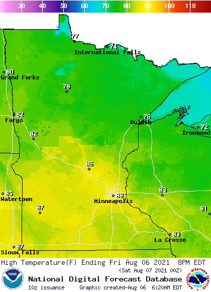
Despite being behind a cold front, the state was seasonably mild Friday morning, with a mix of 50s and 60s.
During the afternoon, northern Minnesota can expect 70s and lower humidity, while southern Minnesota stays warmer and more humid under mostly sunny skies.
A wet weekend
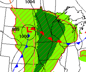
By early Saturday, another weather system starts moving rain into the state that lingers through Sunday.
Although there are shower and storm chances at any time between Saturday and Sunday, the heaviest rainfall is likely Saturday evening into the overnight and possibly again Sunday afternoon or evening.
There is also a risk for isolated severe storms across the southern half of the state, and scattered (a “slight” risk area, in yellow) across southern Minnesota Saturday.

Damaging winds and large hail are the primary risk, but isolated tornadoes are also possible.
While all of Minnesota has a chance to see some precipitation, with much of the state expected to get at least one-quarter inch, rainfall is likely to increase toward the southeast. The southeastern corner of the state could see some widespread totals over 1 inch.
For the Twin Cities, it currently looks like one-half to 1 inch of rain is likely through Sunday, with higher amounts in areas that see stronger storms.
Despite the return of a southerly wind flow over the weekend (those winds should help improve the air quality), high temperatures will remain in the 70s north and 80s south due to the cloud cover and rain.
Extended forecast
More sunshine should return by Monday, which is expected to push temperatures across the state back into the 80s, with upper 80s south.
Here is that forecast for the Twin Cities:
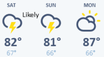
That dry break is brief, with more showers and storms expected to move into Minnesota late Monday and spread across the state by Tuesday, possibly lingering through Wednesday.
The precipitation forecast with that storm is still somewhat uncertain, but it appears that might be a lighter rainfall that the weekend storm.
After that, the extended outlook has the state turning warmer and drier again, so any rainfall Minnesota sees through the middle of next week is crucial in mitigating the state’s worsening drought conditions.
Programming note
You can hear my live weather updates on Minnesota Public Radio at 7:48 a.m. Monday through Friday morning.

