
Steamy Monday; Tuesday t-storm opportunity
Updated weekend rainfall summary
Go Deeper.
Create an account or log in to save stories.
Like this?
Thanks for liking this story! We have added it to a list of your favorite stories.


I mentioned that Minneapolis-St. Paul International Airport tallied 1.20 inches of rain early Sunday morning. That put the weekend rainfall total at MSP airport over two inches. It was welcome rain indeed, and was followed by a dry afternoon in most of the metro area.
A band of significant weekend rain totals extended from western Minnesota into parts of western Wisconsin:
You may have to click on the NWS tweet to see the rainfall details. The map doesn’t include weekend rainfall in southeastern Minnesota and southwestern Wisconsin, which is in the La Crosse Wis. NWS forecast area. Some locations saw very heavy rain on Saturday:
Flash flood watch in parts of western Wisconsin until 1 a.m. Monday
Turn Up Your Support
MPR News helps you turn down the noise and build shared understanding. Turn up your support for this public resource and keep trusted journalism accessible to all.
The portion of western Wisconsin that’s shaded dark-green is in a flash flood watch until 1 a.m. Monday:
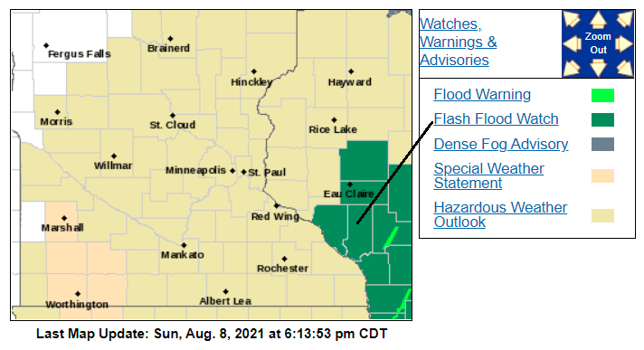
Here are details of the flash flood watch:
National Weather Service La Crosse WI 1007 AM CDT Sun Aug 8 2021 WIZ029-032>034-041>044-053>055-082315- /O.CON.KARX.FF.A.0001.000000T0000Z-210809T0600Z/ /00000.0.ER.000000T0000Z.000000T0000Z.000000T0000Z.OO/ Clark-Buffalo-Trempealeau-Jackson-La Crosse-Monroe-Juneau-Adams- Vernon-Crawford-Richland- Including the cities of Arcadia, Richland Center, Black River Falls, Alma, Neillsville, Whitehall, Prairie Du Chien, Sparta, Viroqua, La Crosse, Tomah, Friendship, and Mauston 1007 AM CDT Sun Aug 8 2021 ...FLASH FLOOD WATCH REMAINS IN EFFECT THROUGH LATE TONIGHT... The Flash Flood Watch continues for * Portions of central Wisconsin, southwest Wisconsin and west central Wisconsin, including the following areas, in central Wisconsin, Adams, Clark and Juneau. In southwest Wisconsin, Crawford, Richland and Vernon. In west central Wisconsin, Buffalo, Jackson, La Crosse, Monroe and Trempealeau. * Through late tonight. * Heavy rainfall Saturday afternoon and evening resulted in saturated soils. Additional storms with heavy rain will be possible this afternoon into the evening, with rainfall rates of 1 to 2 inches per hour possible. This rainfall could quickly result in flash flooding. PRECAUTIONARY/PREPAREDNESS ACTIONS... You should monitor later forecasts and be prepared to take action should Flash Flood Warnings be issued.
Scattered showers and thunderstorms are still possible in southern and central Minnesota and into Wisconsin this Sunday evening and overnight. You can hear updated weather information for Minnesota and western Wisconsin on the Minnesota Public Radio network, and you can see updated weather info on the MPR News live weather blog.
Severe weather outlook
A few strong to severe thunderstorms are possible Sunday evening and overnight. The National Weather Service Storm Prediction Center shows a slight risk (shaded yellow) of severe weather Sunday evening and overnight in portions of Wisconsin, with a marginal risk of severe weather (dark green) in parts of southern Minnesota, the Twin Cities metro area and west-central Wisconsin:
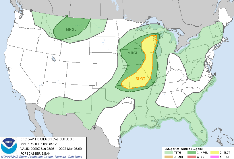
Marginal risk means that an isolated severe thunderstorm is possible. Slight risk means that scattered severe thunderstorms are possible. There is also a severe thunderstorm watch into Sunday evening in some portions of Wisconsin that are within the slight risk area.
The severe weather outlook is updated several times each day by the Storm Prediction Center.
Monday evening and Tuesday thunder chances
Northwestern and north-central Minnesota could see scattered showers and thunderstorms late Monday afternoon and Monday evening. That thunderstorm chance then spreads across much of Minnesota and into western Wisconsin as we go through Tuesday. Check forecast updates.
Temperature trends
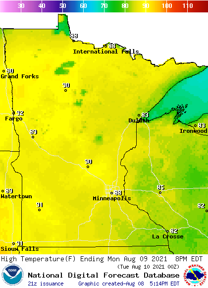
Our average Twin Cities high temp is 82 this time of year. We’ll see metro highs in the upper 80s to around 90 Monday afternoon. Monday highs reach well into the 80s in many areas, with some lower 90s in parts of western Minnesota:
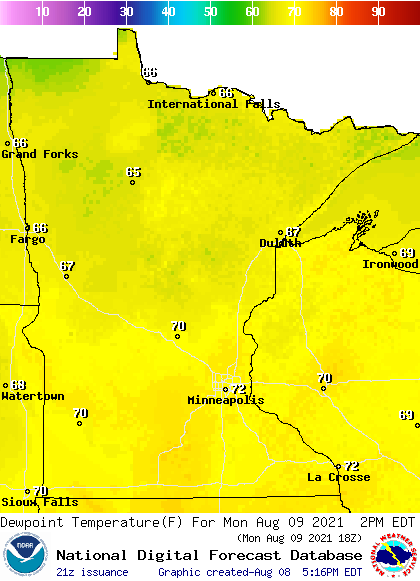
Monday afternoon dew points will be in the steamy 70s in roughly the southern half of Minnesota and parts of western Wisconsin:
Back to forecast high temps, Twin Cities metro area highs are projected to reach the upper 80s Tuesday and Wednesday, followed by mid 80s Thursday and around 80 on Friday.
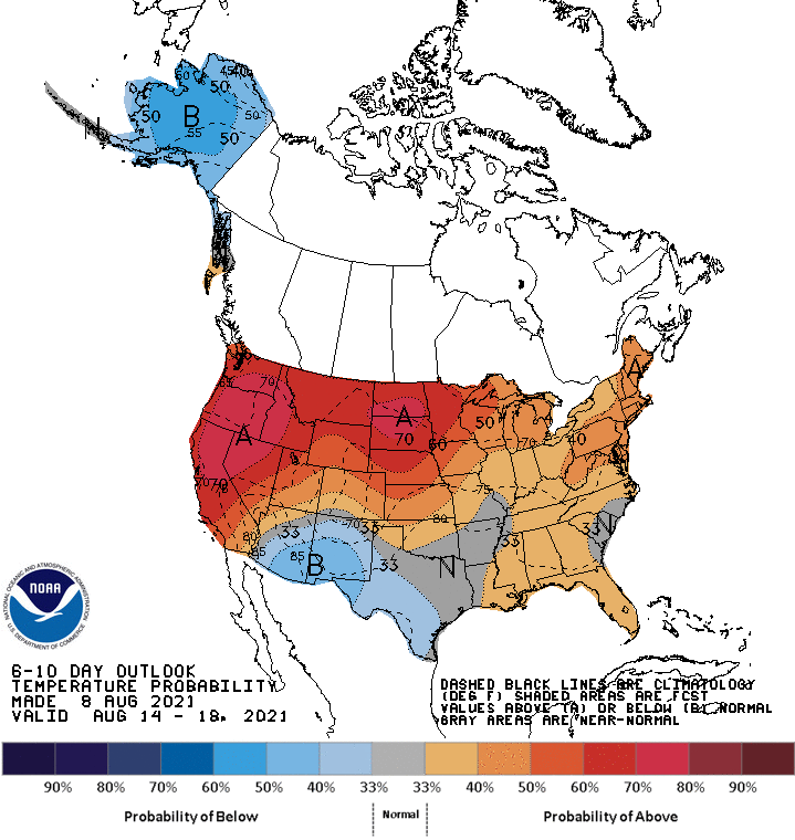
A peek at next weekend shows metro area highs in the mid to upper 80s. Above-normal highs may then continue into the following week. The NWS Climate Prediction Center shows a tendency for above normal temps in Minnesota and western Wisconsin from August 14 through August 18:
Programming note
You can hear my live weather updates on MPR News at 7:35 a.m., 9:35 a.m. and 4:39 p.m. each Saturday and Sunday.

