
Summery but dry weekend; we have a closer look at our drought
Next rain chance is days away for most of the state
Go Deeper.
Create an account or log in to save stories.
Like this?
Thanks for liking this story! We have added it to a list of your favorite stories.


I know we need rain, but we’re currently enjoying some very nice weather across Minnesota and western Wisconsin. We’ll have a dry high pressure system overhead Friday night, then the high will drift eastward Saturday and Sunday. Most of us won’t see any rain this weekend.
Weekend temperatures and dew points
Our average Twin Cities high temperature is 81 degrees this time of year. Most of the metro area will see Saturday highs in the mid-80s. Highs in the 80s are expected across much of Minnesota Saturday afternoon:
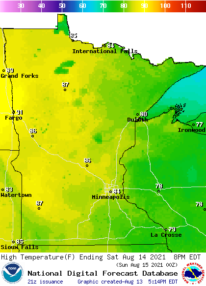
A few spots in far northwestern Minnesota could touch 90 degrees. Northeastern Minnesota and much of western Wisconsin will have Saturday highs in the upper 70s.
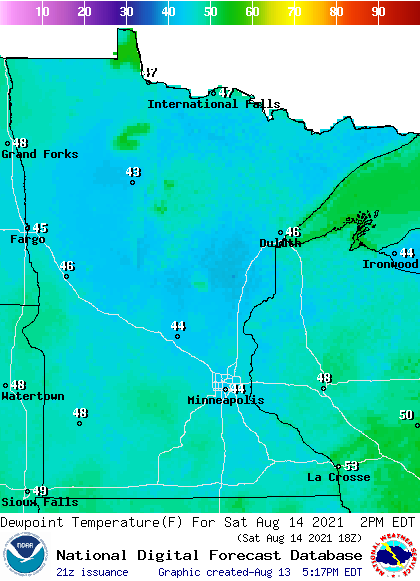
Saturday dew points will be in the very comfortable 40s for much of the day:
Turn Up Your Support
MPR News helps you turn down the noise and build shared understanding. Turn up your support for this public resource and keep trusted journalism accessible to all.
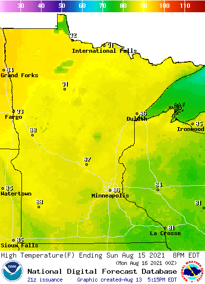
Most of Minnesota and western Wisconsin will have Sunday highs in the 80s, with some lower 90s in parts of northwestern Minnesota:
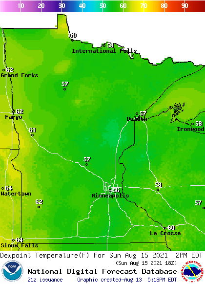
Dew points creep into the upper 50s and lower 60s by Sunday afternoon:
Dry weekend
Outdoor activities in Minnesota and western Wisconsin won’t be interrupted by rain this weekend. Here’s the National Oceanic and Atmospheric Administration’s North American Mesoscale (NAM) forecast model simulated radar for Saturday through Sunday evening:
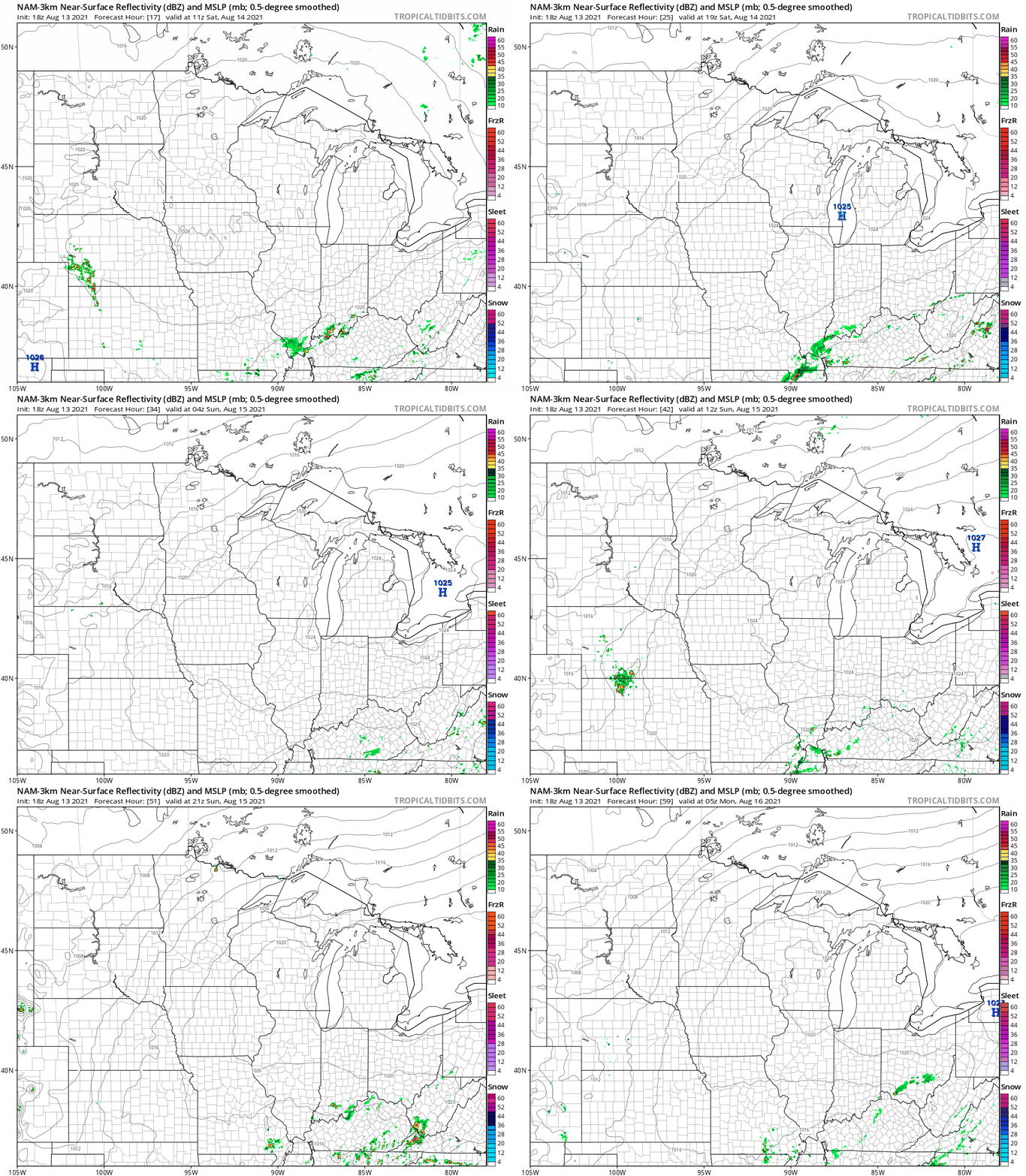
As of now, it looks like western Minnesota could see scattered showers and thunderstorms late Tuesday. All of Minnesota, plus western Wisconsin, will have a chance of scattered showers and thunderstorms Wednesday and Thursday. Check back for forecast updates.
Drought update
Parts of southern Minnesota saw some meaningful rain last weekend, but it was a different story in the north. The Minnesota State Climatology Office has details of our Minnesota rainfall from August 4 through August 10:
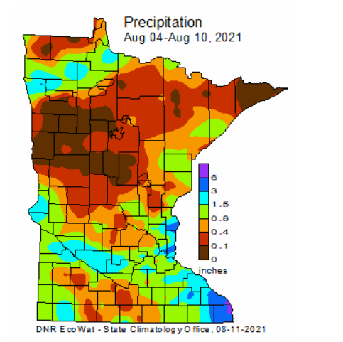
The Climatology Office posted these details on last weekend’s rain:
The on-and-off scattered thunderstorm activity produced an uneven and erratic pattern of precipitation totals, with one prong of higher totals extending from Canby and Granite Falls through the southern Twin Cities area, and another covering extreme southeastern Minnesota. The highest precipitation totals for the event were reported at National Weather Service cooperative observing sites in far southeastern Minnesota, including 6.96 inches near La Crescent, 5.27 inches near Hokah, 4.30 inches at Caledonia and 4.11 inches at the Winona Dam. Totals of 2-3 inches were reported by observers along the western Minnesota River near Granite Falls and Montevideo, as well as in parts of the central, southern and eastern Twin Cities area.
This precipitation event occurred in the midst of a major, escalating drought episode. During the summer, about an inch of rain per week is required to keep precipitation deficits from growing. Thus, areas that received an inch or more effectively held the drought steady, at least temporarily. Areas that received over two inches may have seen small short-term improvements in drought conditions. Unfortunately, approximately 50 percent of the state did not receive even a half-inch of rain over the week of August 4-10, and large pockets of northwestern and far northeastern Minnesota received a tenth of an inch or less. Suffice it to say, these weekly precipitation shortfalls did not help the drought situation.
The latest U.S. Drought Monitor report shows that 95 percent of Minnesota is in drought right now, with slightly more than 7 percent (shaded dark red) in exceptional drought:

Extreme drought (medium red) covers almost 35 percent of Minnesota, from parts of northwestern through central Minnesota and also in portions of northeastern Minnesota.
Severe drought (orange) covers 36 percent of Minnesota, including most of the seven-county Twin Cities metro area. When added together, the severe drought, extreme drought and exceptional drought areas cover almost 78 percent of Minnesota.
The Twin Cities office of the National Weather Service has compiled many interesting details on the current drought situation in Minnesota. Here are some excerpts from the NWS report:
DROUGHT INTENSITY AND EXTENT: WITH THE AUGUST 12TH ISSUANCE OF THE U.S. DROUGHT MONITOR, ALL OF CENTRAL AND SOUTHERN MINNESOTA CONTINUES TO BE CATEGORIZED IN AT LEAST MODERATE DROUGHT (D1), WITH MUCH OF THIS REGION IN SEVERE DROUGHT (D2) OR WORSE CONDITIONS. THE AREA OF EXTREME DROUGHT (D3) ACROSS CENTRAL MINNESOTA WAS EXPANDED FURTHER, WITH IT NOW REACHING DOWN IN THE FAR NORTHWESTERN TWIN CITIES SUBURBS. SOME MINOR IMPROVEMENTS IN DROUGHT CONDITIONS DUE TO HEAVY RAINS DID OCCUR FROM SIBLEY ACROSS RENVILLE COUNTIES AND ALONG THE MINNESOTA AND WISCONSIN BORDER FROM THE EASTERN TWIN CITIES METRO DOWN TO LA CROSSE, WI. HEAVY RAINS IN THE PAST WEEK SAW FURTHER IMPROVEMENTS IN DROUGHT CONDITIONS ACROSS WESTERN WI, WITH DRY CONDITIONS MAINLY CONFINED TO NEAR THE MN BORDER. IN THE PREVIOUS WEEK, RECORD RAINFALLS OF 4 TO 7 INCHES WERE OBSERVED IN THE EAU CLAIRE, WI REGION. OTHER POCKETS OF HEAVY RAIN WERE NOTED IN SOUTHEAST MN AND ACROSS SIBLEY INTO RENVILLE COUNTIES IN CENTRAL MN. OTHERWISE, PRECIPITATION AMOUNTS WILL LOW ENOUGH TO KEEP A STATUS QUO IN THE DROUGHT ACROSS SOUTHERN MN, WITH CONDITIONS CONTINUING TO DETERIORATE ACROSS CENTRAL MN. HYDROLOGIC CONDITIONS: STREAM FLOWS ACROSS MINNESOTA CONTINUE TO RUN WELL BELOW NORMAL, WITH THE LOWEST CONDITIONS BEING EXPERIENCED ALONG THE MISSISSIPPI RIVER FROM MINNEAPOLIS UP INTO CENTRAL MINNESOTA, WHERE MOST LOCATIONS ARE SEEING STREAMFLOWS BELOW THE 10TH PERCENTILE. ELSEWHERE IN MINNESOTA, RIVERS ARE RUNNING MOSTLY BETWEEN THE 15TH AND 25TH PERCENTILE.
Here’s the NWS discussion of drought impacts:
AGRICULTURE IMPACTS: ALTHOUGH RAINS THE PAST WEEK WERE WELCOME, THEY WERE NEITHER WIDESPREAD OR SIGNIFICANT ENOUGH TO PROVIDE SIGNIFICANT IMPROVEMENTS TO AGRICULTURE CONDITIONS ACROSS MN. THE BIGGEST IMPACTS FROM THE DROUGHT CONTINUE TO IMPACT RANGE/PASTURE LAND FOR LIVESTOCK GRAZING. PASTURE CONDITIONS IN MINNESOTA ARE RATED AS 35% VERY POOR, 39% POOR, 19% FAIR, AND JUST 7% AS GOOD OR EXCELLENT. WITH THE POOR PASTURE CONDITIONS, FARMERS ARE CONTINUING TO THIN THEIR LIVESTOCK HERDS DUE TO THE LACK OF FEED. CORN AND SOYBEAN CONDITIONS ARE CONSIDERABLY BETTER IN MINNESOTA, WITH JUST 24% OF THE CORN AND SOYBEAN CROPS RATED AS POOR OR VERY POOR. HOWEVER, WITH JUST 20% OF THE STATES TOPSOIL MOISTURE RATED AS ADEQUATE OR IN SURPLUS, FURTHER DEGRADATION IN CROP CONDITIONS IS LIKELY. IN WISCONSIN, AGRICULTURAL CONDITIONS ARE CONSIDERABLY BETTER, WITH JUST 17% OF THE PASTURE, 5% OF THE CORN, AND 6% OF THE SOYBEAN CROPS RATED AS BEING IN POOR OR VERY POOR CONDITION. .HYDROLOGIC IMPACTS: WITH LOW FLOWS AND WATER LEVELS ACROSS MUCH OF CENTRAL AND NORTHERN MN, THE STATE DEPARTMENT OF NATURAL RESOURCES CONTINUES TO LIMIT THE AMOUNT OF WATER THAT CAN BE DRAWN OUT OF HYDROLOGIC SYSTEMS IN THESE REGIONS OF THE STATE. IN PARTICULAR, LOW LAKE LEVELS ACROSS CENTRAL MN ARE STARTING TO IMPACT ACCESS TO LAKES, WITH WATER BECOMING TO SHALLOW TO ALLOW FOR THE USE OF SOME BOAT RAMPS.
Programming note
You can hear updated weather information for Minnesota and western Wisconsin on the Minnesota Public Radio network, and you can see updated weather info on the MPR News live weather blog.
You can hear my live weather updates on MPR News at 7:35 a.m., 9:35 a.m. and 4:39 p.m. each Saturday and Sunday.

