
Summery breezes Sunday; still searching for rain
A look at the rainfall deficit
Go Deeper.
Create an account or log in to save stories.
Like this?
Thanks for liking this story! We have added it to a list of your favorite stories.


Our official Twin Cities rainfall, measured at Minneapolis-St. Paul International Airport, was slightly over two inches last weekend. MSP airport has seen just one-hundredth of an inch of rain since Sunday.
Today’s climate summary shows that the rainfall total since June 1 at MSP airport is 5.26 inches below normal:
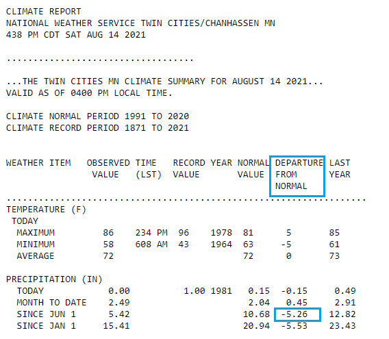
We’re still searching for our next rain.
Forecast models show that scattered showers and an isolated thunderstorm are possible late Saturday night and early Sunday morning in west-central Minnesota. Most of Minnesota and western Wisconsin can expect a dry Sunday.
Turn Up Your Support
MPR News helps you turn down the noise and build shared understanding. Turn up your support for this public resource and keep trusted journalism accessible to all.
You can hear updated weather information for Minnesota and western Wisconsin on the Minnesota Public Radio network, and you can see updated weather info on the MPR News live weather blog.
Next best rain chance?
Some forecast models show spotty rain opportunities in Minnesota Tuesday night and Wednesday.
Several forecast models show a good chance of some periods of rain later in the week. The National Oceanic and Atmospheric Administration’s Global Forecast System GFS model shows the potential rain pattern for Thursday morning through Friday evening:

Pay less attention to the exact location of the rain in the GFS model than the fact that there are numerous areas of rain. Let’s hope that many of us see at least some periods of rain on Thursday and Friday.
Temperature trends
Sunday highs reach the 80s in most areas, with 90s in northwestern Minnesota:
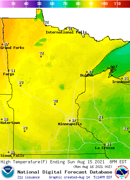
The Twin Cities metro area is expected to top out in the upper 80s…well above our average August 15 high of 81.
Sunday afternoon dew points will be in the fairly comfortable 40s to lower 50s in eastern Minnesota, with stickier upper 50s to lower 60s in parts of the west:

Back to forecast high temps, Twin Cities metro area highs are projected to reach the mid 80s on Monday, followed by upper 80s Tuesday and Wednesday. Our highs retreat to the mid 80s Thursday and around 80 on Friday.
Rain opportunities next weekend and beyond?
The NWS Climate Prediction Center shows a tendency of above-normal rainfall in Minnesota and western Wisconsin from next Sunday into the following week:

That doesn’t mean that it will rain each of those days, it’s that there is a tendency for above-normal rainfall totals over that time span.
We’ll see if that pans out.
Programming note
You can hear my live weather updates on MPR News at 7:35 a.m., 9:35 a.m. and 4:39 p.m. each Saturday and Sunday.

