
Breezy and warm Sunday; a look at rain chances this week
Fire weather update for Minnesota
Go Deeper.
Create an account or log in to save stories.
Like this?
Thanks for liking this story! We have added it to a list of your favorite stories.


The coverage of scattered morning showers and thunderstorms in parts of northwestern Minnesota is shrinking as of 10 a.m. Sunday. Most of Minnesota will have a dry afternoon.
You can hear updated weather information for Minnesota and western Wisconsin on the Minnesota Public Radio network, and you can see updated weather info on the MPR News live weather blog.
Near critical fire weather conditions
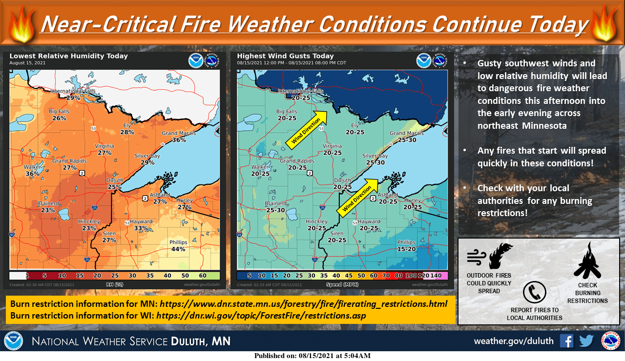
Fire weather conditions are near-critical in much of Minnesota today, due to low relative humidity and dry conditions plus gusty winds:
Turn Up Your Support
MPR News helps you turn down the noise and build shared understanding. Turn up your support for this public resource and keep trusted journalism accessible to all.
A fire weather watch has been posted from northern Minnesota through central Minnesota and parts of southern Minnesota until 8 p.m. this Sunday evening:
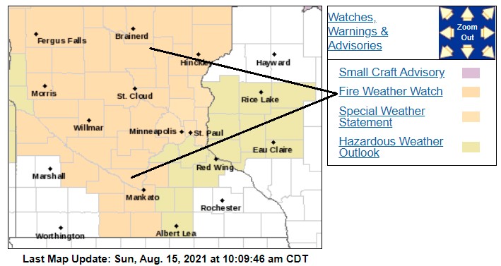
Carver County of the west metro is included in the fire weather watch.
Here are details of the fire weather watch:
URGENT - FIRE WEATHER MESSAGE National Weather Service Twin Cities/Chanhassen MN 1006 AM CDT Sun Aug 15 2021 ...CRITICAL FIRE WEATHER CONDITIONS POSSIBLE THIS AFTERNOON... .South/southwest winds 15 to 20 mph with occasional gusts near 25 mph, afternoon humidity around 20 percent, and dry will result in possible critical fire weather conditions this afternoon. MNZ041>045-047>052-054>059-064>068-073>076-082-083-091-092-152315- /O.NEW.KMPX.FW.A.0004.210815T1600Z-210816T0100Z/ Douglas-Todd-Morrison-Mille Lacs-Kanabec-Stevens-Pope-Stearns- Benton-Sherburne-Isanti-Lac Qui Parle-Swift-Chippewa-Kandiyohi- Meeker-Wright-Yellow Medicine-Renville-McLeod-Sibley-Carver- Redwood-Brown-Nicollet-Le Sueur-Watonwan-Blue Earth-Martin- Faribault- 1006 AM CDT Sun Aug 15 2021 ...FIRE WEATHER WATCH IN EFFECT UNTIL 8 PM CDT THIS EVENING FOR LOW HUMIDITY AND BREEZY SOUTHERLY WINDS... The National Weather Service in Twin Cities/Chanhassen has issued a Fire Weather Watch, which is in effect until 8 PM CDT this evening. * AFFECTED AREA...Most of south central, central, and northern Minnesota. * WIND...South/southwest at 15 to 20 mph, with occasional gusts near 25 mph. * HUMIDITY...Min RH near 20 percent * IMPACTS...Any fires that develop will likely spread rapidly. Outdoor burning is not recommended. PRECAUTIONARY/PREPAREDNESS ACTIONS... A Fire Weather Watch means that critical fire weather conditions are forecast to occur. Listen for later forecasts and possible Red Flag Warnings.
You can check the links at the beginning of this blog for updates on possible red flag warnings Sunday afternoon.
Temperature trends
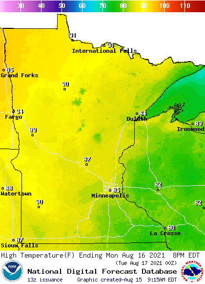
Sunday highs will be mainly in the 80s, with some lower 90s in parts of northwestern and north-central Minnesota.
Monday highs will be similar to today’s highs:
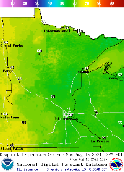
Monday dew points will be mainly in the 50s, with some stickier 60s to the west:
Back to high temperatures, Twin Cities metro area highs are projected to reach the upper 80s to around 90 on Tuesday, Wednesday and Thursday, then lower 80s on Friday.
Next best rain chance?
Some forecast models show spotty rain opportunities in Minnesota Tuesday night and Wednesday.
Several forecast models show a good chance of some periods of rain later in the week. The National Oceanic and Atmospheric Administration’s Global Forecast System GFS model has this potential rain pattern for Thursday morning through Friday evening:
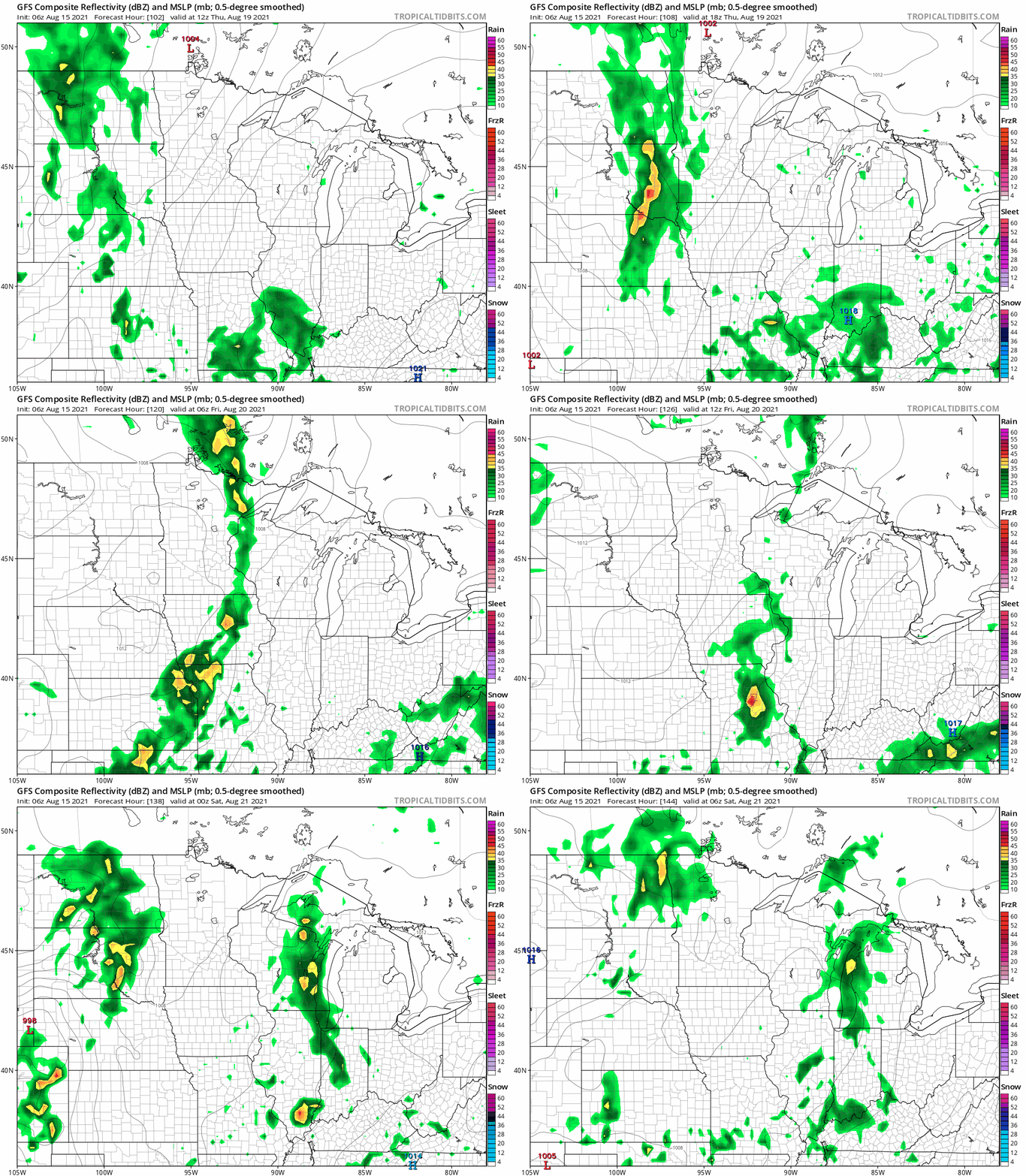
Pay less attention to the exact location of the rain in the GFS model than the fact that there are numerous areas of rain. Let’s hope that many of us see at least some periods of rain on Thursday and Friday.
Sunset times

Sunset is at 8:18 this Sunday evening in the Twin Cities. On September 15, our sunset is at 7:23 p.m. On October 15 the sun will set at 6:27 p.m. in the Twin Cities….that’s almost two hours earlier than today’s sunset.
Programming note
You can hear my live weather updates on MPR News at 7:35 a.m., 9:35 a.m. and 4:39 p.m. each Saturday and Sunday.

