
Heat builds in, then rain chances increase late week
Smoke and haze make a return across Minnesota
Go Deeper.
Create an account or log in to save stories.
Like this?
Thanks for liking this story! We have added it to a list of your favorite stories.


Heat and humidity are on the rise the first half of the week, and smoky haze returns to the skies of Minnesota. Then, needed rain finally makes a comeback.
Monday’s forecast
The northern Midwest, including Minnesota, is under a broad area of high pressure, which is keeping skies predominantly clear and dry.
Under clear skies, most of Minnesota dropped into the 60s overnight, with a few 50s south. Winds from the south kept temperatures from getting any cooler, and that same wind pattern will push highs above average.
The entire state can expect afternoon temperatures in the 80s, with 90s in portions of western and northern Minnesota.
Turn Up Your Support
MPR News helps you turn down the noise and build shared understanding. Turn up your support for this public resource and keep trusted journalism accessible to all.

Dew points are also on the rise, meaning slightly more humidity Monday, but unfortunately still not enough to significantly reduce the fire risk which remains elevated due to dry and breezy conditions.
The upper-level wind pattern is expected to bring smoke and haze back into Minnesota from the fires in the western U.S.
Most of the smoke should remain aloft, causing minimal air quality impacts, but hazy skies and more reds and oranges in the sunrises and sunsets are likely.
Hot and humid
The heat and humidity nudge even higher on Tuesday, with most of Minnesota in the 90s for highs.
While making it feel stickier, the higher humidity should help reduce the fire risk somewhat.
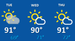
Highs mostly in the 90s and elevated humidity continue for much of the state through Thursday, with lows in the 60s and lower 70s.
Here is that forecast for the Twin Cities:
Extended forecast
Meanwhile, the forecast stays predominantly dry, although northern Minnesota may see a couple isolated showers near the Canadian border on Tuesday.
Tuesday also stays hazy.
Starting Thursday, the pattern shifts and more active weather returns. A few showers and storms are expected to spread across Minnesota during the day Thursday, with most of the state seeing at least isolated precipitation chances by Thursday evening.
Scattered showers and storms are likely Friday as a cold front moves through, which also breaks the heat in time for the weekend.
Periods of showers and storms linger through at least early next week, and some weather models project a stronger round of storms Sunday.
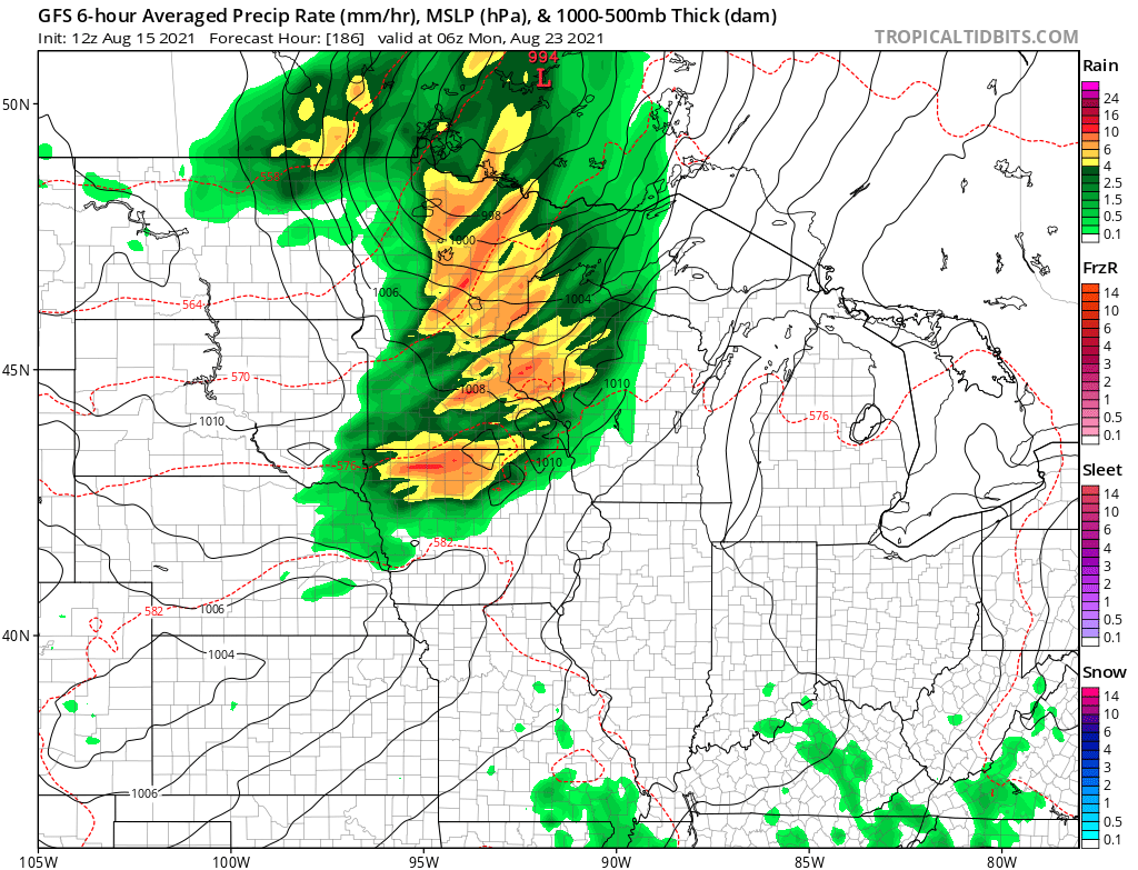
We will monitor that possibility as the weekend approaches, but it looks as though much of Minnesota could see at least a half inch of rain through Sunday.
Northwestern Minnesota may see even higher amounts, which is where the rain is needed most given the extreme drought areas in that part of the state.
Programming note
You can hear my live weather updates on Minnesota Public Radio at 7:48 a.m. Monday through Friday morning.

