
Needed rain Friday is the start of a more active weather pattern
Much cooler temperatures by the weekend
Go Deeper.
Create an account or log in to save stories.
Like this?
Thanks for liking this story! We have added it to a list of your favorite stories.


Minnesota sees a few opportunities for rain over the next week, beginning with storms Friday that could bring the best chance for both soaking rain and severe weather.
Behind that storm, temperatures plunge then rebound quickly.
Friday’s forecast
Like the past couple mornings, Friday began warm and muggy, with most of Minnesota in at least the 60s, and much of the state in the low 70s.
With more clouds moving across Minnesota Friday, it will not be as hot as the mid-week was, but highs will still be above average in the mid and upper 80s.
Turn Up Your Support
MPR News helps you turn down the noise and build shared understanding. Turn up your support for this public resource and keep trusted journalism accessible to all.

The one area that will be slightly cooler is western Minnesota, where clouds and rain associated with a potent storm system move in earlier, limiting daytime heating.
In fact, the storm is already bringing a couple of spotty showers and isolated storms to the western edge of the state as of 9 a.m.
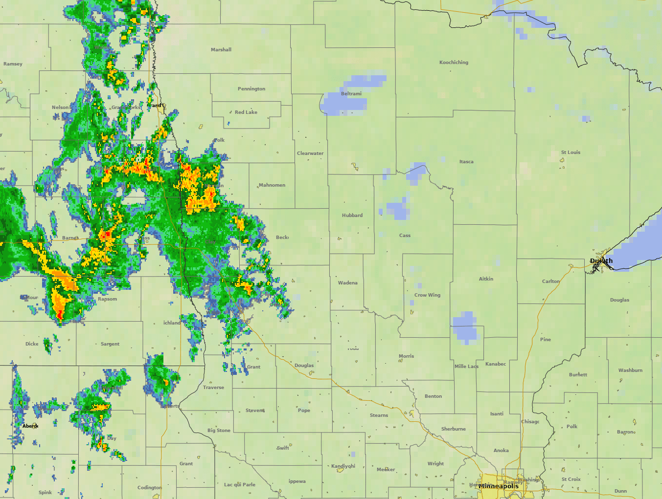
Scattered showers and storms move into the rest of western Minnesota Friday morning, then spread throughout the state during the afternoon and evening hours. For the Twin Cities area, the most likely timing for storms is Friday evening through the early overnight.

The storms will produce some areas of heavy rain, which is most likely in western — particularly northwestern — Minnesota given that the low-pressure center of the state will clip the northwestern edge of the state as it tracks northeast.
Much of Minnesota can expect a half-inch to an inch of rain, with higher amounts possible northwest.
That higher rainfall potential lines up with some of the worst drought areas, which is very beneficial.
Unfortunately, not as much is expected in the Arrowhead, where the rainfall would help with ongoing fires. That area could see totals under a quarter inch.
The downside of the storm is that most of Minnesota is in a “slight” severe weather risk area, which means scattered severe storms are likely especially in the late afternoon through early overnight hours Friday.
Wind and hail are the primary threat, but western Minnesota in particular may see a couple tornadoes.
Temperatures cool
Behind Friday’s front, temperatures dive. Some spots including the Twin Cities, may see their highs for Saturday at midnight (still in the 70s), with even cooler temperatures in the afternoon.
Most of Minnesota will be in the 60s Saturday afternoon, with a couple temperatures near 70s south.
The state rebounds into the 70s by Sunday, then 80s return to southern Minnesota by early next week.
Here are the forecast highs for the Twin Cities:
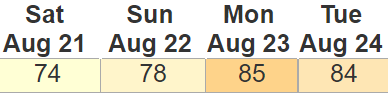
The 74 shown Saturday is the high for the day that is likely to occur at the start of the day, with upper 60s expected in the afternoon.
More rain
Although Friday’s storm looks like the most potent and wet of the coming week, the overall pattern does remain more active.
Minnesota is likely to see another widespread chance for showers and storms Sunday into Monday, and that includes what presently looks like an isolated severe weather risk.
Timing is still somewhat uncertain, but additional periods of rain currently appear possible on Tuesday and perhaps Thursday into Friday.
We will update timings and rainfall potentials as those other weather systems get closer.
However, adding up all the current rain chances in the next week, the forecast puts southern and western Minnesota with good prospects to see over an inch of rain total—wonderful news for drought-stricken areas.

Programming note
You can hear my live weather updates on Minnesota Public Radio at 7:48 a.m. Monday through Friday morning.

