
A taste of September this Saturday, with cool temps and gusty winds
Dew points are dropping
Go Deeper.
Create an account or log in to save stories.
Like this?
Thanks for liking this story! We have added it to a list of your favorite stories.


I’ll get to the Saturday forecast shortly, but here’s a quick recap of our Friday p.m. weather.
Thunderstorms were strongest yesterday in western Minnesota and parts of central Minnesota. There were some impressive rainfall amounts Friday afternoon/evening in portions of northwestern and west-central Minnesota, including 2 inches in Fergus Falls, 2.75 inches in Park Rapids and 2.88 inches of rain in Wadena.
There were two reports of brief tornado touchdowns Friday evening near Belgrade, Minn., in Stearns County…one at 6:30 p.m. and another at 6:51 pm Friday.
The official Friday night rain total at Minneapolis-St. Paul International Airport was just one-tenth of an inch, which leaves our official Twin Cities rainfall tally .33 of an inch below normal for August and 6.04 inches below normal since June 1.
Turn Up Your Support
MPR News helps you turn down the noise and build shared understanding. Turn up your support for this public resource and keep trusted journalism accessible to all.
The northern third of Minnesota could see a few spotty showers at times this Saturday, but it’ll stay dry in much of Minnesota and western Wisconsin.
You can hear updated weather information for Minnesota and western Wisconsin on the Minnesota Public Radio network, and you can see updated weather info on the MPR News live weather blog.
Air quality alert northeast
The Minnesota Pollution Control Agency continues an air quality alert this weekend in portions of northeastern Minnesota:

The alert is due to smoke from the Greenwood fire in Superior National Forest. Here are details of the air quality alert, from the MPCA:
MNZ012-020-021-232000- Northern Cook/Northern Lake-Southern Cook/North Shore-Southern Lake/North Shore- Including the tribal nation of Grand Portage Including the city of Two Harbors 210 PM CDT Fri Aug 20 2021 ...AIR QUALITY ALERT NOW IN EFFECT THROUGH 3 PM CDT MONDAY... * WHAT...The Minnesota Pollution Control Agency has issued an Air Quality Alert for fine particle pollution. The Air Quality Index (AQI) is expected to reach the Orange or Unhealthy for Sensitive Groups category. * WHERE...Lake and Cook counties in northeast Minnesota. * WHEN...Through 3 PM CDT Monday. * IMPACTS...Sensitive groups, such as people with lung disease (including asthma), heart disease, and children and older adults, may experience health effects. * ADDITIONAL DETAILS...The Greenwood fire continues to burn in the Superior National Forest in northeast Minnesota. The fire is located near Greenwood Lake, or approximately 15 miles southwest of Isabella. On Thursday morning, the size of the fire was estimated to be 4,734 acres with no containment. Southerly winds are expected to continue over the region until Saturday morning and smoke will continue to impact areas near and immediately downwind of the fire to the north. A cold front will pass through the area Saturday morning and winds will become westerly. Smoke will impact areas near and immediately downwind of the fire to the east on Saturday. Winds will switch from the north on Saturday evening, then become southerly on Sunday afternoon. Smoke from the Canadian Quetico fires will impact Cook County from Saturday evening through Sunday as the wind direction changes. Smoke from the Greenwood fire will impact downwind areas to the north on Sunday. On Monday, smoke impacts will be limited to downwind of the Greenwood fire to the north. Fine particle levels are expected to reach the Orange AQI category, a level that is considered unhealthy for sensitive groups, for the affected downwind area. PRECAUTIONARY/PREPAREDNESS ACTIOOurNS... Sensitive groups, such as people with lung disease (including asthma), heart disease, and children and older adults, should limit prolonged or heavy exertion. For information on current air quality conditions in your area and to sign up for daily air quality forecasts and alert notifications by email, text message, phone, or the Minnesota Air mobile app, visit https://www.pca.state.mn.us/air/current-air-quality. You can find additional information about health and air quality at https://www.pca.state.mn.us/air/why-you-should-care-air-quality-and- health.
Cool temps and drier dew points
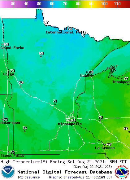
A cold front ushered in cooler and drier air overnight. Highs in northern Minnesota will be in the 60s Saturday afternoon, with 70s south:
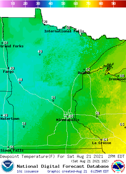
Dew points will be in the comfortable upper 40s to mid 50s in most areas by afternoon, with stickier 60s to the far southeast:
It’ll be breezy today, with gusts over 20 mph in the south and over 25 mph at times in the north.
This Updraft blog will be updated around 10:40 a.m. with a look at Sunday and the week ahead.
Programming note
You can hear my live weather updates on MPR News at 7:35 a.m., 9:35 a.m. and 4:39 p.m. each Saturday and Sunday.

