
Sunday evening t-storm chances, warmer Monday; Update on Henri
Several rain opportunities this week
Go Deeper.
Create an account or log in to save stories.
Like this?
Thanks for liking this story! We have added it to a list of your favorite stories.


Tropical storm Henri has already brought heavy rains to parts of New York and New Jersey:
Henri will bring additional heavy rain to those areas plus portions of New England today into Monday.
This Sunday morning video is from Block Island, Rhode Island:
As of 10 a.m. Sunday, Henri was moving closer to making landfall:
Turn Up Your Support
MPR News helps you turn down the noise and build shared understanding. Turn up your support for this public resource and keep trusted journalism accessible to all.
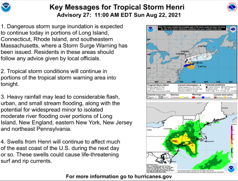
Here are the key messages concerning Henri, from the NWS National Hurricane Center:
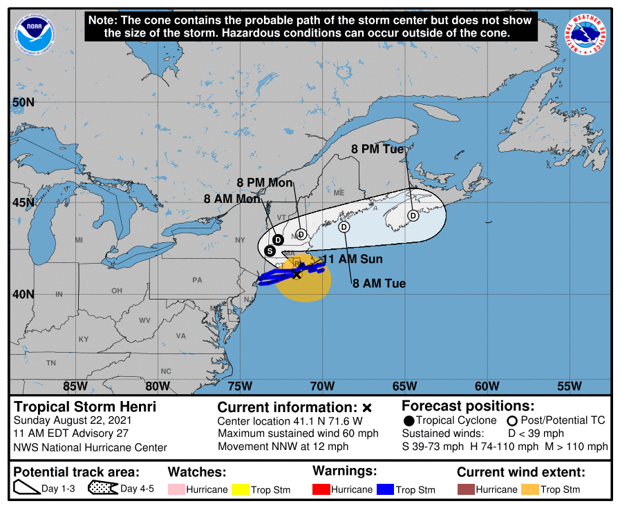
Here’s a closer look at the projected track of Henri, which includes the “cone of uncertainty” for the track of Henri’s center:
This is the Sunday morning update on Henri:
BULLETIN Tropical Storm Henri Advisory Number 27 NWS National Hurricane Center Miami FL AL082021 1100 AM EDT Sun Aug 22 2021 ...CENTER OF HENRI PASSING CLOSE TO BLOCK ISLAND AS THE STORM HEADS FOR SOUTHERN NEW ENGLAND... ...DANGEROUS STORM SURGE, STRONG GUSTY WINDS, AND FLOODING RAINFALL ARE EXPECTED ACROSS PORTIONS OF THE NORTHEASTERN UNITED STATES... SUMMARY OF 1100 AM EDT...1500 UTC...INFORMATION ----------------------------------------------- LOCATION...41.1N 71.6W ABOUT 15 MI...25 KM E OF MONTAUK POINT NEW YORK ABOUT 50 MI...80 KM SSW OF PROVIDENCE RHODE ISLAND MAXIMUM SUSTAINED WINDS...60 MPH...95 KM/H PRESENT MOVEMENT...NNW OR 335 DEGREES AT 12 MPH...19 KM/H MINIMUM CENTRAL PRESSURE...987 MB...29.15 INCHES WATCHES AND WARNINGS -------------------- CHANGES WITH THIS ADVISORY: The Storm Surge Watch has been discontinued from East Rockaway Inlet to west of Mastic Beach, New York, and from north of Chatham, Massachusetts to Sagamore Beach, Massachusetts, including Cape Cod Bay. The Tropical Storm Warning from East Rockaway Inlet, New York to Manasquan Inlet, New Jersey has been discontinued. SUMMARY OF WATCHES AND WARNINGS IN EFFECT: A Storm Surge Warning is in effect for... * South shore of Long Island from Mastic Beach to Montauk Point New York * North shore of Long Island from Montauk Point to Flushing New York * Flushing New York to Chatham Massachusetts * Nantucket, Martha's Vineyard, and Block Island A Tropical Storm Warning is in effect for... * East Rockaway Inlet New York to Chatham Massachusetts, including Long Island * Block Island, Nantucket and Martha's Vineyard A Storm Surge Warning means there is a danger of life-threatening inundation, from rising water moving inland from the coastline. For a depiction of areas at risk, please see the National Weather Service Storm Surge Watch/Warning Graphic, available at hurricanes.gov. This is a life-threatening situation. Persons located within these areas should take all necessary actions to protect life and property from rising water and the potential for other dangerous conditions. Promptly follow evacuation and other instructions from local officials. A Tropical Storm Warning means that tropical storm conditions are expected somewhere within the warning area. Interests elsewhere in the northeastern U.S. should monitor the progress of Henri. For storm information specific to your area, including possible inland watches and warnings, please monitor products issued by your local National Weather Service forecast office. DISCUSSION AND OUTLOOK ---------------------- At 1100 AM EDT (1500 UTC), the center of Tropical Storm Henri was located by an Air Force Reserve reconnaissance aircraft and NOAA Doppler weather radars near latitude 41.1 North, longitude 71.6 West. Henri is moving toward the north-northwest near 12 mph (19 km/h). A north-northwestward motion with a decrease in forward speed is expected for the next few hours, followed by a turn toward the northwest this afternoon. The center of Henri is currently passing near Block Island and on the forecast track the center is expected to make landfall in Rhode Island by early afternoon. Henri is forecast to slow down and possibly stall near the Connecticut-New York border tonight, followed by an east-northeastward motion across northern Connecticut and southern Massachusetts on Monday. Data from the aircraft, Doppler radars, and surface observations indicate that maximum sustained winds have decreased to near 60 mph (95 km/h) with higher gusts. Little change in strength is expected until landfall occurs, followed by rapid weakening after Henri moves inland over southern New England. Tropical-storm-force winds extend outward up to 125 miles (205 km) from the center. A Weatherflow station on Block Island, Rhode Island, recently reported a sustained wind of 52 mph (84 km/h) and a gust to 65 mph (105 km/h). Another Weatherflow station near Point Judith, Rhode Island, recently measured a sustained wind of 51 mph (82 km/h) and a gust to 69 mph (111 km/h). The NOAA C-MAN station at Buzzards Bay, Massachusetts, recently measured a sustained wind of 49 mph (79 km/h) and a gust to 57 mph (92 km/h), while an amateur radio operator in Westport, Massachusetts, recently reported a sustained wind of 41 mph (66 km/h) and a gust to 62 mph (100 km/h). The latest minimum central pressure estimated from Air Force Reserve reconnaissance aircraft data is 987 mb (29.15 inches). HAZARDS AFFECTING LAND ---------------------- Key messages for Henri can be found in the Tropical Cyclone Discussion under AWIPS header MIATCDAT3, WMO header WTNT43 KNHC and on the web at www.hurricanes.gov/graphics_at3.shtml?key_messages. STORM SURGE: The combination of a dangerous storm surge and the tide will cause normally dry areas near the coast to be flooded by rising waters moving inland from the shoreline. The water could reach the following heights above ground somewhere in the indicated areas if the peak surge occurs at the time of high tide... Flushing, NY to Chatham, MA including Narragansett Bay, Buzzards Bay, Vineyard Sound, and Nantucket Sound...2-4 ft North shore of Long Island from Flushing, NY to Montauk Point, NY including Long Island Sound...2-4 ft South shore of Long Island from Mastic Beach to Montauk Point, NY...2-4 ft Chatham, MA to Merrimack River, MA including Cape Cod Bay and Massachusetts Bay...1-2 ft East Rockaway Inlet, NY to Mastic Beach, NY...1-2 ft Recent reports from an amateur radio operator in Newport, Rhode Island, indicate that storm surge inundation near 1 ft has occurred, with water reported in the streets in some areas of the city. The deepest water will occur along the immediate coast in areas of onshore winds, where the surge will be accompanied by large and dangerous waves. Surge-related flooding depends on the relative timing of the surge and the tidal cycle, and can vary greatly over short distances. For information specific to your area, please see products issued by your local National Weather Service forecast office. WIND: Tropical storm conditions are expected to continue in the tropical storm warning area into tonight. Some tree and power line damage has already been reported across southern Rhode Island. RAINFALL: Henri is expected to produce rainfall amounts of 3 to 6 inches over portions of Long Island, New England, southeast New York, New Jersey, and northeast Pennsylvania Sunday into Monday, with isolated maximum totals near 12 inches. Heavy rainfall from Henri may result in considerable flash, urban, and small stream flooding, along with the potential for widespread minor to isolated moderate river flooding. TORNADOES: The risk for a tornado or two continues today across parts of southern New England. SURF: Swells generated by Henri should diminish around Bermuda later today. Swells are expected to increase across much of the east coast of the U.S. and Atlantic Canada today and continue into Monday. These swells could cause life-threatening surf and rip current conditions. Please consult products from your local weather office.
The National Hurricane Center will issue updates on Henri as needed today.
________________________________________________________________________________________________
Henri landfall update
________________________________________________________________________________________________
Back in Minnesota
Most of Minnesota and western Wisconsin will have plenty of sunshine today, along with comfortable temps and dew points. Highs will be in the 70s, with a few spots in the metro area and far southern Minnesota touching 80.
Far western Minnesota could see some scattered showers/t-storms by late afternoon or early evening, then that rain chance spreads into eastern Minnesota and western Wisconsin as we go through the remainder of Sunday evening and the overnight hours of Sunday night. The NWS Storm Prediction Center shows a slight risk of severe weather later this afternoon into tonight in far southwestern Minnesota. Here’s the severe weather discussion from the Twin Cities office of the NWS:
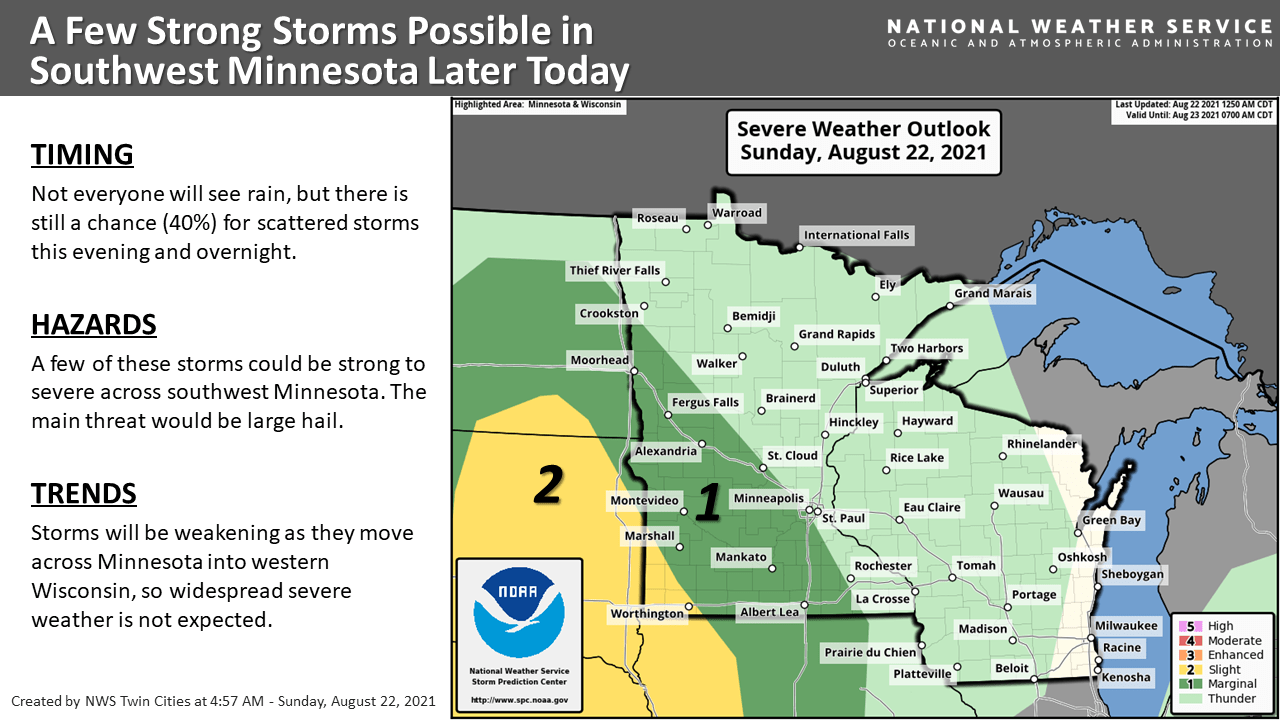
Scattered severe thunderstorms are possible in the yellow-shaded area in far southwestern Minnesota, with an isolated severe thunderstorm possible in the area that’s shaded darker green.
You can hear updated weather information for Minnesota and western Wisconsin on the Minnesota Public Radio network, and you can see updated weather info on the MPR News live weather blog.
Air quality alert continues in the northeast
The Minnesota Pollution Control Agency continues an air quality alert this weekend and until 3 p.m. Monday in portions of northeastern Minnesota:
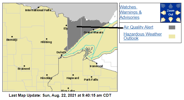
Here are details of the air quality alert:
Northern Cook/Northern Lake-Southern Cook/North Shore-Southern Lake/North Shore- Including the tribal nation of Grand Portage Including the cities of Isabella, Two Harbors, Silver Bay, and Grand Marais 1220 PM CDT Sat Aug 21 2021 ...AIR QUALITY ALERT REMAINS IN EFFECT THROUGH 3 PM CDT MONDAY... * WHAT...The Minnesota Pollution Control Agency has issued an Air Quality Alert for fine particle pollution. The Air Quality Index (AQI) is expected to reach the Orange or Unhealthy for Sensitive Groups category. * WHERE...Lake and Cook counties in Northeast Minnesota. * WHEN...Through 3 PM CDT Monday. * IMPACTS...Sensitive groups, such as people with lung disease (including asthma), heart disease, and children and older adults, may experience health effects. * ADDITIONAL DETAILS...The Greenwood fire continues to burn in the Superior National Forest in northeast Minnesota. The fire is located near Greenwood Lake, or approximately 15 miles southwest of Isabella. On Friday, the fire grew from 4,734 acres to an estimated area of 9,067 acres. Winds will be westerly on Saturday, and smoke will impact areas near and immediately downwind of the fire to the east. Winds will switch from the north on Saturday evening, then become southerly on Sunday afternoon. Smoke from the Canadian Quetico fires will impact Cook County from Saturday evening through Sunday as the wind direction changes. Smoke from the Greenwood fire will impact downwind areas to the north on Sunday. On Monday, smoke impacts will be limited to downwind of the Greenwood fire to the north. Fine particle levels are expected to reach the Orange AQI category, a level that is considered unhealthy for sensitive groups, for the affected downwind area. PRECAUTIONARY/PREPAREDNESS ACTIONS... Sensitive groups, such as people with lung disease (including asthma), heart disease, and children and older adults, should limit prolonged or heavy exertion. For information on current air quality conditions in your area and to sign up for daily air quality forecasts and alert notifications by email, text message, phone, or the Minnesota Air mobile app, visit https://www.pca.state.mn.us/air/current-air-quality. You can find additional information about health and air quality at https://www.pca.state.mn.us/air/why-you-should-care-air-quality-and- health.
You can check current air quality reports here.
Temperature trends
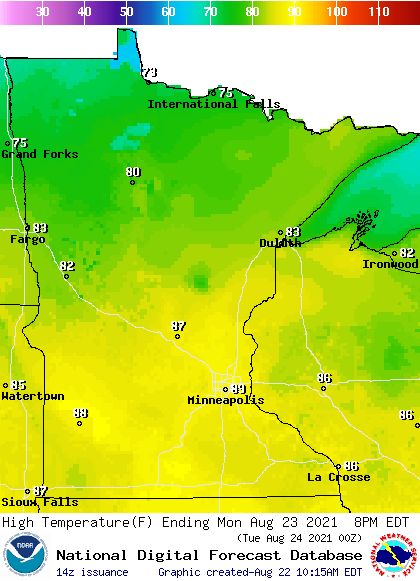
Highs in the mid and upper 80s return to many areas on Monday:
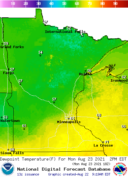
Monday afternoon dew points will be in the sticky 60s in southern Minnesota, the metro area, and western Wisconsin:
Back to high temperatures, Twin Cities metro area highs are projected to reach the upper 80s Monday and Tuesday, then lower 80s Wednesday and upper 70s Thursday and Friday.
We could see periods of showers and thunderstorms Tuesday and Tuesday evening and Thursday afternoon into Friday.
Programming note
You can hear my live weather updates on MPR News at 7:35 a.m., 9:35 a.m. and 4:39 p.m. each Saturday and Sunday.

