
Warmer and muggier Monday. Scattered storms Monday night and Tuesday.
Go Deeper.
Create an account or log in to save stories.
Like this?
Thanks for liking this story! We have added it to a list of your favorite stories.


Widely scattered thunderstorms dampened parts of Minnesota Sunday night. Early this Monday morning a scattering of storms lingers over the southeastern corner of this state.
Heat and humidity returning
Monday will be a warmer, muggier day than the weather we enjoyed over the weekend. Look for afternoon high temperatures from the upper 70s in the northwest to the upper 80s in the Twin Cities area and the southeast. The Twin Cities should warm to about 88 with sunshine and a light southwest breeze. Dew points will be on the rise as well
Muggier Tuesday
Tuesday will be the least comfortable day this week. Highs again will range from the upper 70s northwest to the upper 80s southeast. Dew points will continue to climb. The dew point in the Twin Cities is likely to flirt with 70 Tuesday afternoon – that’s Floridian.
Thunderstorms expected
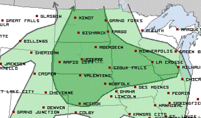
Widely scattered thunderstorms are likely Monday night, Tuesday and Tuesday night but locations and timing are fuzzy. At this point, there is a marginal risk for severe weather for the 24-hour period ending at 7 a.m. on Tuesday.
Cooler beginning Wednesday
Temperatures and dew points will back off on Wednesday and for the remainder of the week.
Unsettled later in the week
A series of disturbances later in the week will bring the likelihood of more widespread rain across most of the state from Thursday into next weekend.
Turn Up Your Support
MPR News helps you turn down the noise and build shared understanding. Turn up your support for this public resource and keep trusted journalism accessible to all.

