
Areas of thunderstorms into Saturday night, with severe weather possible
Quiet in most areas Sunday
Go Deeper.
Create an account or log in to save stories.
Like this?
Thanks for liking this story! We have added it to a list of your favorite stories.


Strong to severe thunderstorms moved through parts of Minnesota on Saturday, and the potential for severe weather lingers into the overnight hours of Saturday night. Heavy rain is also possible. The daylight hours of Sunday look fairly quiet.
A tornado watch continues to 9 p.m. Saturday in southwestern Minnesota:
A severe thunderstorm watch continues until 11 p.m. this Saturday in much of southern Minnesota, plus Carver and Scott counties of the Twin Cities metro area:
Some locations in the southern third of Minnesota and over the border into Wisconsin could see periods of heavy rain Saturday night, resulting in localized flooding.
Turn Up Your Support
MPR News helps you turn down the noise and build shared understanding. Turn up your support for this public resource and keep trusted journalism accessible to all.
In addition to the watches listed above, the updated severe weather outlook from the NWS Storm Prediction Center shows that an enhanced risk of severe weather continues through the overnight hours of Saturday night from southwestern Minnesota through the Twin Cities metro area:
Enhanced risk means that numerous severe thunderstorms are possible:

Scattered severe thunderstorms are possible in the area that’s shaded yellow on the severe weather outlook.
Make sure that you have a way to get severe weather warnings Saturday night. MPR, NOAA weather radio, or a weather app are among your options for forecasts, watches and warnings.
You can hear updated weather information for Minnesota and western Wisconsin on the Minnesota Public Radio network, and you can see updated weather info on the MPR News live weather blog.
Severe weather reports
There were several severe weather warnings Saturday morning into early afternoon from west-central Minnesota through parts of central and east-central Minnesota.
Hail and wind reports can be found on the Storm Prediction Center page. 100 on the SPC hail report listing equals one inch diameter hail. Times listed are in Universal time, which is 5 hours ahead of CDT; so 1700 is noon CDT.
Several severe weather warnings, including some tornado warnings, were issued for parts of southwestern and south-central Minnesota Saturday evening. There were multiple reports of trees down in southern Minnesota.
Quieter on Sunday
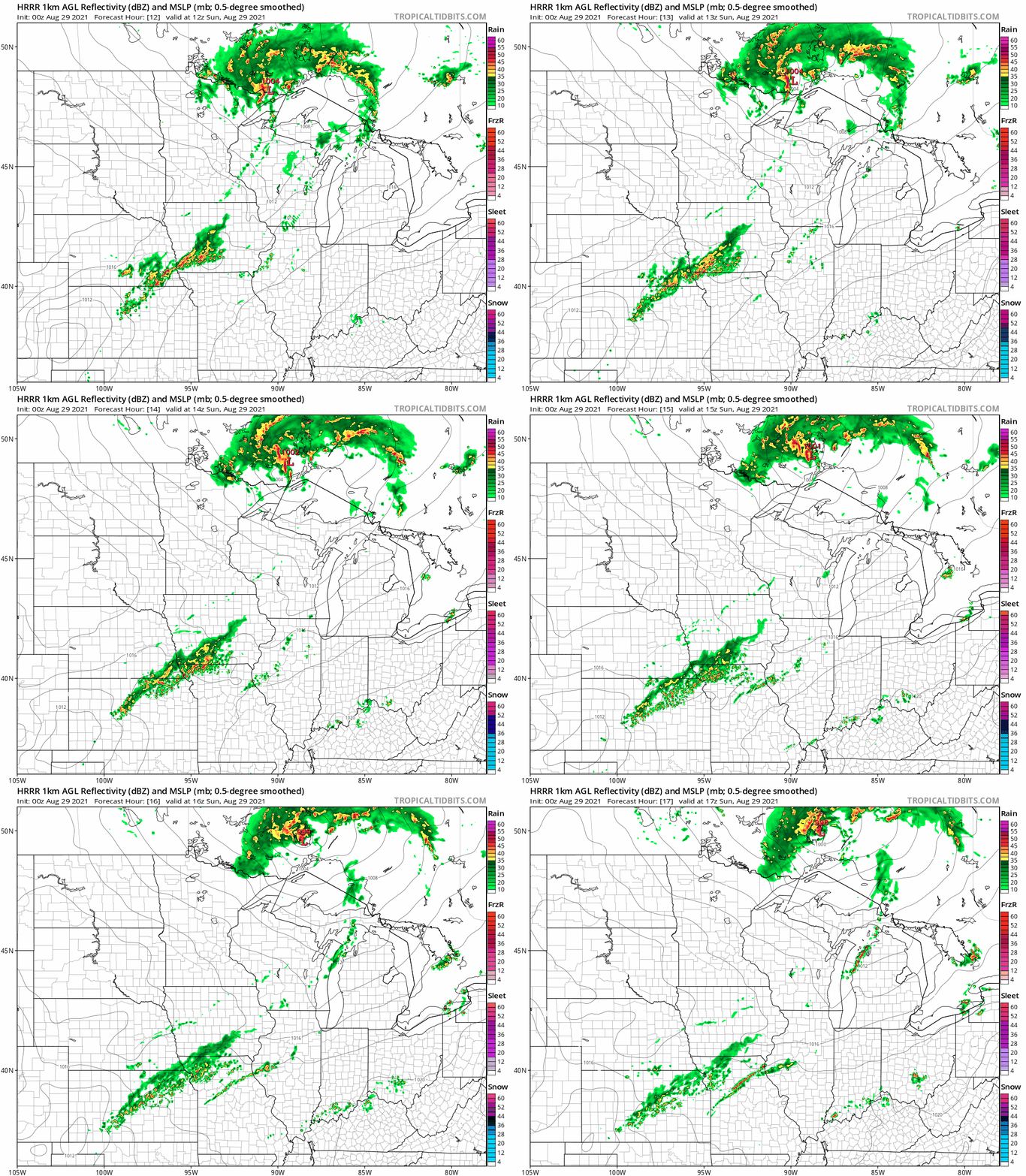
The daylight hours of Sunday look fairly quiet across most of Minnesota. There could be a few scattered showers and thunderstorms Sunday morning in northeastern Minnesota. A stray early morning shower is possible in southeastern Minnesota and western Wisconsin.
The National Oceanic and Atmospheric Administration’s High-Resolution Rapid-Refresh forecast model shows the potential rain pattern from 7 a.m. to noon on Sunday:
Check forecast updates.
Temperature trends
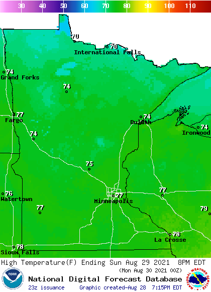
Sunday highs will be mainly in the 70s:
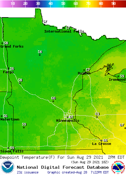
Sunday dew points will be in the comfortable 50s to the west and north, with stickier 60s southeast and east:
Back to forecast highs, Twin Cities metro area high temps are projected to reach the upper 70s Monday, then around 80 Tuesday and Wednesday. Metro highs return to the upper 70s for Thursday and Friday.
Hurricane Ida
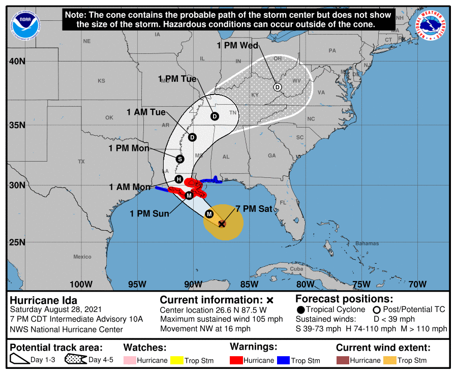
Hurricane Ida strengthened on Saturday, and could be a Category 4 hurricane when it makes landfall on Sunday. This is from the National Hurricane Center’s Saturday evening Ida update:
Rapid strengthening is forecast during the next 12 to 24 hours and Ida is expected to be an extremely dangerous major hurricane when it makes landfall along the Louisiana coast on Sunday.
Here’s the forecast track of Ida:
Here’s the complete Saturday evening Ida update:
BULLETIN Hurricane Ida Intermediate Advisory Number 10A NWS National Hurricane Center Miami FL AL092021 700 PM CDT Sat Aug 28 2021 ...IDA FORECAST TO STRENGTHEN RAPIDLY BEFORE LANDFALL... ...LIFE-THREATENING STORM SURGE, POTENTIALLY CATASTROPHIC WIND DAMAGE, AND FLOODING RAINFALL EXPECTED TO IMPACT THE NORTHERN GULF COAST BEGINNING SUNDAY MORNING... SUMMARY OF 700 PM CDT...0000 UTC...INFORMATION ---------------------------------------------- LOCATION...26.6N 87.5W ABOUT 200 MI...320 KM SSE OF THE MOUTH OF THE MISSISSIPPI RIVER ABOUT 285 MI...460 KM SE OF HOUMA LOUISIANA MAXIMUM SUSTAINED WINDS...105 MPH...165 KM/H PRESENT MOVEMENT...NW OR 320 DEGREES AT 16 MPH...26 KM/H MINIMUM CENTRAL PRESSURE...969 MB...28.61 INCHES WATCHES AND WARNINGS -------------------- CHANGES WITH THIS ADVISORY: None. SUMMARY OF WATCHES AND WARNINGS IN EFFECT: A Storm Surge Warning is in effect for... * East of Rockefeller Wildlife Refuge Louisiana to the Alabama/Florida border * Vermilion Bay, Lake Borgne, Lake Pontchartrain, Lake Maurepas, and Mobile Bay A Hurricane Warning is in effect for... * Intracoastal City Louisiana to the Mouth of the Pearl River * Lake Pontchartrain, Lake Maurepas, and Metropolitan New Orleans A Tropical Storm Warning is in effect for... * Cameron Louisiana to west of Intracoastal City Louisiana * Mouth of the Pearl River to the Alabama/Florida border A Storm Surge Warning means there is a danger of life-threatening inundation, from rising water moving inland from the coastline, during the next 36 hours in the indicated locations. For a depiction of areas at risk, please see the National Weather Service Storm Surge Watch/Warning Graphic, available at hurricanes.gov. This is a life-threatening situation. Persons located within these areas should take all necessary actions to protect life and property from rising water and the potential for other dangerous conditions. Promptly follow evacuation and other instructions from local officials. A Hurricane Warning means that hurricane conditions are expected somewhere within the warning area. A warning is typically issued 36 hours before the anticipated first occurrence of tropical-storm-force winds, conditions that make outside preparations difficult or dangerous. Preparations to protect life and property should be rushed to completion. A Tropical Storm Warning means that tropical storm conditions are expected somewhere within the warning area within 36 hours. For storm information specific to your area, including possible inland watches and warnings, please monitor products issued by your local National Weather Service forecast office. DISCUSSION AND OUTLOOK ---------------------- At 700 PM CDT (0000 UTC), the eye of Hurricane Ida was located near latitude 26.6 North, longitude 87.5 West. Ida is moving toward the northwest near 16 mph (26 km/h), and this general motion should continue through late Sunday or early Monday, followed by a slower northward motion on Monday. A northeastward turn is forecast by Monday night. On the forecast track, the center of Ida will continue moving across the central and northern Gulf of Mexico tonight and early Sunday, and make landfall along the coast of Louisiana within the hurricane warning area Sunday afternoon or evening. Ida is then forecast to move well inland over portions of Louisiana and western Mississippi on Monday and Monday night. Data from the NOAA Hurricane Hunter aircraft indicate that maximum sustained winds are near 105 mph (165 km/h) with higher gusts. Rapid strengthening is forecast during the next 12 to 24 hours and Ida is expected to be an extremely dangerous major hurricane when it makes landfall along the Louisiana coast on Sunday. Rapid weakening is expected after landfall. Hurricane-force winds extend outward up to 30 miles (45 km) from the center and tropical-storm-force winds extend outward up to 125 miles (205 km). The estimated minimum central pressure based on data from the NOAA Hurricane Hunters is 969 mb (28.61 inches). HAZARDS AFFECTING LAND ---------------------- Key messages for Ida can be found in the Tropical Cyclone Discussion under AWIPS header MIATCDAT4, WMO header WTNT44 KNHC, and on the web at hurricanes.gov/graphics_at4.shtml?key_messages. STORM SURGE: The combination of a dangerous storm surge and the tide will cause normally dry areas near the coast to be flooded by rising waters moving inland from the shoreline. The water could reach the following heights above ground somewhere in the indicated areas if the peak surge occurs at the time of high tide... Morgan City, LA to Mouth of the Mississippi River...10-15 ft Mouth of the Mississippi River to Ocean Springs, MS including Lake Borgne...7-11 ft Intracoastal City, LA to Morgan City, LA including Vermilion Bay...6-9 ft Ocean Springs, MS to MS/AL border...4-7 ft Lake Pontchartrain...5-8 ft Lake Maurepas...4-6 ft Pecan Island, LA to Intracoastal City, LA...3-5 ft MS/AL border to AL/FL border including Mobile Bay...2-4 ft Sabine Pass to Pecan Island, LA...1-3 ft Overtopping of local levees outside of the Hurricane and Storm Damage Risk Reduction System is possible where local inundation values may be higher than those shown above. The deepest water will occur along the immediate coast near and to the east of the landfall location, where the surge will be accompanied by large and dangerous waves. Surge-related flooding depends on the relative timing of the surge and the tidal cycle, and can vary greatly over short distances. For information specific to your area, please see products issued by your local National Weather Service forecast office. WIND: Hurricane conditions are expected in the hurricane warning area along the Louisiana coast beginning Sunday with tropical storm conditions expected to begin by late tonight or early Sunday morning. These conditions will spread inland over portions of Louisiana and Mississippi Sunday night and Monday. RAINFALL: Heavy rainfall from Ida will begin to impact the Louisiana coast Sunday morning, spreading northeast into the Lower Mississippi Valley later Sunday into Monday. Total rainfall accumulations of 8 to 16 inches with isolated maximum amounts of 20 inches are possible across southeast Louisiana into southern Mississippi through Monday. This rainfall is likely to result in life-threatening flash and urban flooding and significant riverine flooding impacts. Elsewhere across eastern Louisiana, Mississippi, far southwestern Alabama and the Middle Tennessee Valley -- considerable flash and riverine flooding impacts are likely on Monday and Tuesday, with rainfall totals of 4 to 8 inches possible. Rainfall from Ida will begin to affect the Ohio Valley by mid-week, resulting in flash and riverine flooding impacts. Rainfall impacts from Ida will diminish across western Cuba this evening as the storm continues to lift northward away from the island. Additional 1 to 2 inches of rain with isolated maximum amounts of 4 inches possible across western Cuba through this evening. These rainfall amounts may produce flash floods and mudslides. TORNADOES: Tornadoes will be possible Sunday into Monday across the northern Gulf coast states including parts of eastern Louisiana, Mississippi, central and southern Alabama, and the Florida Panhandle. The longest duration tornado threat will exist across southeast Louisiana and southern Mississippi. SURF: Swells are beginning to reach the northern Gulf coast and will continue to affect that area through Monday. These swells are likely to cause life-threatening surf and rip current conditions. Please consult products from your local weather office.
The National Hurricane Center issues tropical updates every three hours.
Programming note
You can hear my live weather updates on MPR News at 7:35 a.m., 9:35 a.m. and 4:39 p.m. each Saturday and Sunday.

