
Dry Labor Day weekend in many areas; Warmest meteorological summer
Temps rebound Saturday afternoon
Go Deeper.
Create an account or log in to save stories.
Like this?
Thanks for liking this story! We have added it to a list of your favorite stories.


Meteorological summer, which consists of our three warmest months (June, July and August), has ended.
Official Twin Cities temperature records are tallied at Minneapolis-St. Paul International Airport. Summer 2021 temperature data reveals that we just completed our warmest meteorological summer in Twin Cities weather records:

Our average summer temperature (which is the average of all the daily low temps and high temps) was three-tenths of a degree warmer in 2021 than it was during our meteorological summer of 1988.
A closer look reveals that the average of our summer 2021 high temps in the Twin Cities ranked 5th warmest:
Turn Up Your Support
MPR News helps you turn down the noise and build shared understanding. Turn up your support for this public resource and keep trusted journalism accessible to all.

But our summer 2021 low temps were the warmest in Twin Cities weather records:

Combining the highs and lows, summer 2021 was our warmest meteorological summer on record in the Twin Cities.
Several other spots in Minnesota also saw their warmest summer:
Labor Day weekend shower chance?
Many areas will have a dry Labor Day weekend.
There have been some very scattered Saturday morning showers in northeastern Minnesota. Additional scattered showers and an isolated thunderstorm will be possible in north-central and northeastern Minnesota, plus parts of northwestern Wisconsin, later Saturday afternoon and Saturday evening. A stray shower could also develop in central Minnesota.
You can hear updated weather information for Minnesota and western Wisconsin on the Minnesota Public Radio network, and you can see updated weather info on the MPR News live weather blog.
Scattered showers and an isolated thunderstorm could develop in northeastern Minnesota and northwestern Wisconsin Sunday afternoon and evening. Much of Labor Day will be dry, but some forecast models show areas of showers and thunderstorms in Minnesota and western Wisconsin Monday evening and overnight Monday night.
Temperature trends
Saturday highs will be mainly in the 70s in Minnesota and western Wisconsin. Our average Twin Cities metro area high is 77 degrees this time of year, and some spots in the metro area could touch 77 Saturday afternoon.
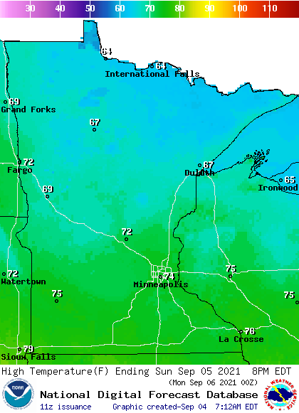
Sunday highs will in the 60s in roughly the northern third of Minnesota, with 70s elsewhere:
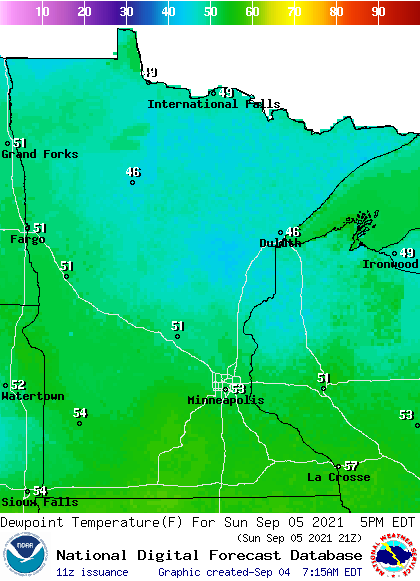
Sunday dew points will be in the comfortable 40s and 50s:
Labor Day high temps reach the 80s in west-central and southwestern Minnesota, with mainly 70s elsewhere:
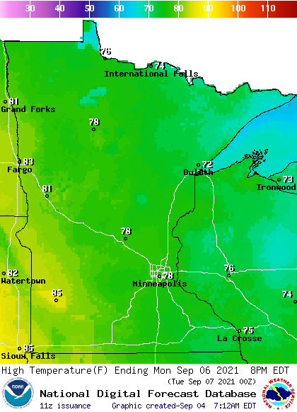
There could be some 60s in Cook County of northeastern Minnesota.
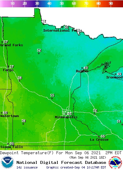
Monday dew points will be in the comfortable 40s and 50s:
Back to high temperatures, Twin Cities metro area highs are projected to reach the mid 70s Tuesday, Wednesday and Thursday, followed by upper 70s on Friday.
Programming note
You can hear my live weather updates on MPR News at 7:35 a.m., 9:35 a.m. and 4:39 p.m. each Saturday and Sunday.

