
Much of Minnesota see 80s for Labor Day
Storms move across the state overnight, followed by a windy Tuesday
Go Deeper.
Create an account or log in to save stories.
Like this?
Thanks for liking this story! We have added it to a list of your favorite stories.


Labor Day will be the warmest day of the week for much of Minnesota, with a chance for storms overnight. Then a mostly dry and seasonable pattern prevails the remainder of the week.
Labor Day
Under clear skies and with low dew points, temperatures are able to heat and cool quickly, allowing a large range between highs and lows. Monday morning was an example of that.
Coming off a mild Sunday, where all but northern Minnesota made it into the 70s, the state had a brisk start Monday, with most of the state in the 40s, and a few 50s south and west.
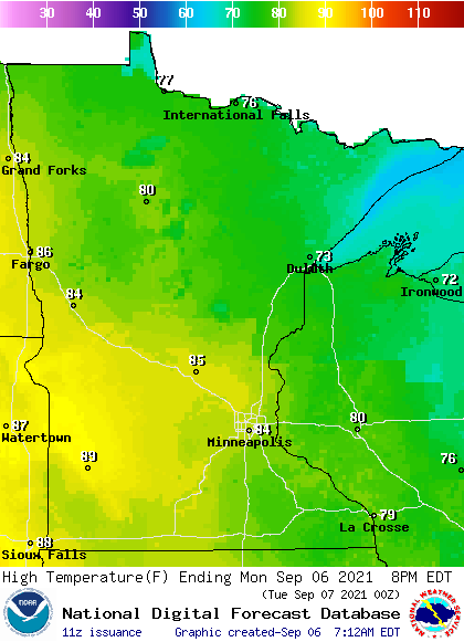
However, the clear skies and low humidity lets the state warm quickly during the day. Minnesota will also be ahead of a warm front and the warm southerly winds, dry air and sunshine combine to return most of Minnesota into the 80s.
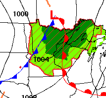
By Monday evening, the same storm that brought the warm front will start moving showers and storms into northern Minnesota. That wet weather spreads south and east across the state during the overnight as a cold front moves across Minnesota.
The low pressure of that storm will track just north of our border, bringing the best chance for rain and storms north. This includes an isolated chance for severe weather in northern Minnesota overnight, with wind and hail as the primary risk.
Turn Up Your Support
MPR News helps you turn down the noise and build shared understanding. Turn up your support for this public resource and keep trusted journalism accessible to all.
Northeastern Minnesota is likely to see the highest rainfall amounts, with widespread amounts over a quarter inch and slightly more in areas that see thunderstorms.
Rainfall amounts quickly diminish as you head south, with the southern edge of Minnesota likely to miss out on the precipitation entirely.
Extended forecast
By Tuesday morning, the precipitation clears east of the state except for the Arrowhead, where isolated showers and storms could linger through the day.
Behind the cold front, windy conditions prevail Tuesday, with gusts that are likely to top 30 mph at times.
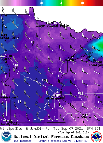
It will be a colder, northwest wind that also drops highs back into the 60s and 70s Tuesday.
Drier conditions then prevail for most of the state through the end of the week. The one exception is northern Minnesota, where unsettled weather brings chances for a few showers or storms most days.
This will actually be a beneficial pattern for northern Minnesota as that is the part of the state under the most extreme drought conditions. The Arrowhead especially may see areas with rainfall totals that exceed an inch of precipitation through the end of the week.
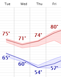
Meanwhile, most of Minnesota stays predominantly sunny, which helps high temperatures rebound to the upper 70s and low 80s by the end of the week.
Here is that Twin Cities forecast:
Programming note
You can hear my live weather updates on Minnesota Public Radio at 7:48 a.m. Monday through Friday morning.

