
Rain spreads across Minnesota Thursday
Temperatures remain above average.
Go Deeper.
Create an account or log in to save stories.
Like this?
Thanks for liking this story! We have added it to a list of your favorite stories.


A slow-moving system brings showers and storms to Minnesota Thursday, while also nudging temperatures slightly cooler.
Thursday’s forecast
Minnesota is starting Thursday off with everything from fog in northern Minnesota to a couple of thunderstorms along the southeastern border.
This is because a boundary of low pressure is sitting over western Minnesota that is trapped between high pressure areas over the Rockies and Great Lakes. Thus, northeastern Minnesota still has more stable conditions (like fog, then clearer skies), while western Minnesota is currently in the narrow flow of moisture between the highs and has a few showers and occasional storms.
That low pressure boundary slowly shifts east during the day, bringing rain chances to most of Minnesota by Thursday evening.
Turn Up Your Support
MPR News helps you turn down the noise and build shared understanding. Turn up your support for this public resource and keep trusted journalism accessible to all.
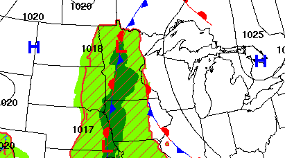
There will be occasional thunderstorms also, but they are not expected to be severe.
For the Twin Cities, spotty activity could begin in the afternoon, however the most likely time for precipitation is in the evening.
Meanwhile, mild temperatures continue, with all of Minnesota starting Thursday in the 50s and 60s, except for the Arrowhead in the 40s.
Because of the clouds and moisture moving in, highs will not be as warm as the past couple days. Most of the state will be in the 70s, with a couple low 80s, especially in eastern and northern Minnesota, which start the day with a bit more sunshine.
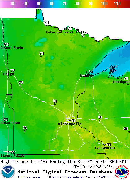
This is still 5 to 15 degrees above average for late September.
Rain persists Friday and may linger into the weekend.
That extended forecast will be updated around 9 a.m.
Programming note
You can hear my live weather updates on Minnesota Public Radio at 7:48 a.m. Monday through Friday morning.

