
Rain continues its slow march across Minnesota Friday
Southeastern Minnesota clings to the 80s again.
Go Deeper.
Create an account or log in to save stories.
Like this?
Thanks for liking this story! We have added it to a list of your favorite stories.


A slow-moving storm is bringing showers and occasional storms through the state, and cooling highs in most areas to the upper 60s and low 70s.
Friday’s forecast
Much like Thursday, the weather pattern Friday finds Minnesota with low pressure on the western side of the state, and that lower pressure is trapped between high pressure areas over the Northern Plains and Great Lakes.
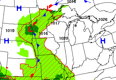
This pattern, especially the strong high pressure to the east, essentially blocks advancement of the low pressure, and means the moisture is very slow to move east.
Therefore, most of the rain Friday will be in a corridor from southwest to northeast Minnesota.
Turn Up Your Support
MPR News helps you turn down the noise and build shared understanding. Turn up your support for this public resource and keep trusted journalism accessible to all.
There will be occasional thunderstorms also, but they are not expected to be severe.
Although there could be some stray activity during the afternoon, the rain is not likely to make it to southeastern Minnesota, including the Twin Cities, until Friday evening.
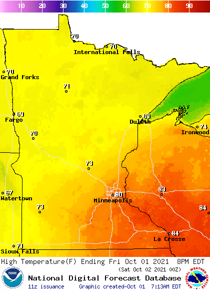
Meanwhile, with much of the state either under clouds overnight, or still in a warmer flow ahead of the low pressure, most of Minnesota is starting very mild for the first day of October, with morning lows in the 60 and just a few 50s north. By contrast, average lows this time of year are in the 30s and 40s, with the Twin Cities at 47.
Because southeastern Minnesota is still in a warmer wind pattern ahead of the low pressure and could see a little more sunshine early in the day, that is the one spot where 80s are still likely, while the rest of Minnesota will be near 70 for highs.
The rain starts to clear Saturday as slowly as it moved in.
That weekend forecast will be updated around 9:30 a.m.
Programming note
You can hear my live weather updates on Minnesota Public Radio at 7:48 a.m. Monday through Friday morning.

