
Foggy start to Monday, then some sun; mild temps linger this week
Fall color update for leaf-peepers
Go Deeper.
Create an account or log in to save stories.
Like this?
Thanks for liking this story! We have added it to a list of your favorite stories.


The Sunday high temp at Minneapolis St. Paul International Airport was 73 degrees, which matched our Saturday high. Our average Twin Cities high temp is 65 degrees this time of year.
Sunshine and light northerly breezes made it a beautiful autumn afternoon.

Fog develops Sunday night and lingers into Monday a.m.
A high pressure system will spread over eastern Minnesota and western Wisconsin Sunday night into Monday. Winds will lighten up, allowing radiational cooling to drop temperatures to the dew point. That’ll cause areas of dense fog.
Turn Up Your Support
MPR News helps you turn down the noise and build shared understanding. Turn up your support for this public resource and keep trusted journalism accessible to all.
A dense fog advisory covers the Twin Cities metro area and much of eastern Minnesota plus west-central and northwestern Wisconsin from 11 p.m. this Sunday to 9 a.m. on Monday:


Here are details of the dense fog advisory, which includes the Twin Cities:
URGENT - WEATHER MESSAGE National Weather Service Twin Cities/Chanhassen MN 249 PM CDT Sun Oct 3 2021 MNZ043>045-049>053-058>063-066>070-075>077-WIZ014-015-023-040600- /O.NEW.KMPX.FG.Y.0010.211004T0400Z-211004T1400Z/ Morrison-Mille Lacs-Kanabec-Stearns-Benton-Sherburne-Isanti- Chisago-Meeker-Wright-Hennepin-Anoka-Ramsey-Washington-McLeod- Sibley-Carver-Scott-Dakota-Nicollet-Le Sueur-Rice-Polk-Barron- St. Croix- Including the cities of Little Falls, Princeton, Mora, St Cloud, Sauk Rapids, Elk River, Cambridge, Center City, Litchfield, Monticello, Minneapolis, Blaine, St Paul, Stillwater, Hutchinson, Gaylord, Chanhassen, Chaska, Victoria, Shakopee, Hastings, St Peter, Le Sueur, Faribault, Osceola, Rice Lake, and Hudson 249 PM CDT Sun Oct 3 2021 ...DENSE FOG ADVISORY IN EFFECT FROM 11 PM THIS EVENING TO 9 AM CDT MONDAY... * WHAT...Visibility as low as one quarter mile in dense fog. * WHERE...Portions of northwest and west central Wisconsin and central, east central and south central Minnesota. * WHEN...From 11 PM this evening to 9 AM CDT Monday. * IMPACTS...Hazardous driving conditions due to low visibility. PRECAUTIONARY/PREPAREDNESS ACTIONS... If driving, slow down, use your headlights, and leave plenty of distance ahead of you.
Some locations could also see patchy drizzle or mist early Monday.
You can hear updated weather information for Minnesota and western Wisconsin on the Minnesota Public Radio News network, and you can see updated weather info on the MPR News live weather blog.
Temperature trends
The Twin Cities metro area, much of Minnesota and western Wisconsin will see Monday afternoon highs in the 70s:
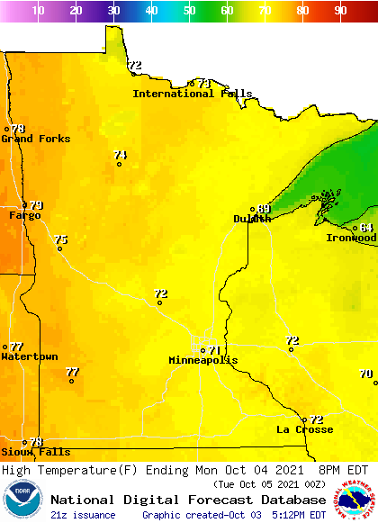
There’ll be some 60s in northeastern Minnesota and far northwestern Wisconsin.
Monday dew points will be in the comfortable 50s and upper 40s:

Back to high temps, Twin Cities metro area highs are projected to reach the lower 70s Tuesday and Wednesday, followed by mid 70s on Thursday and Friday.
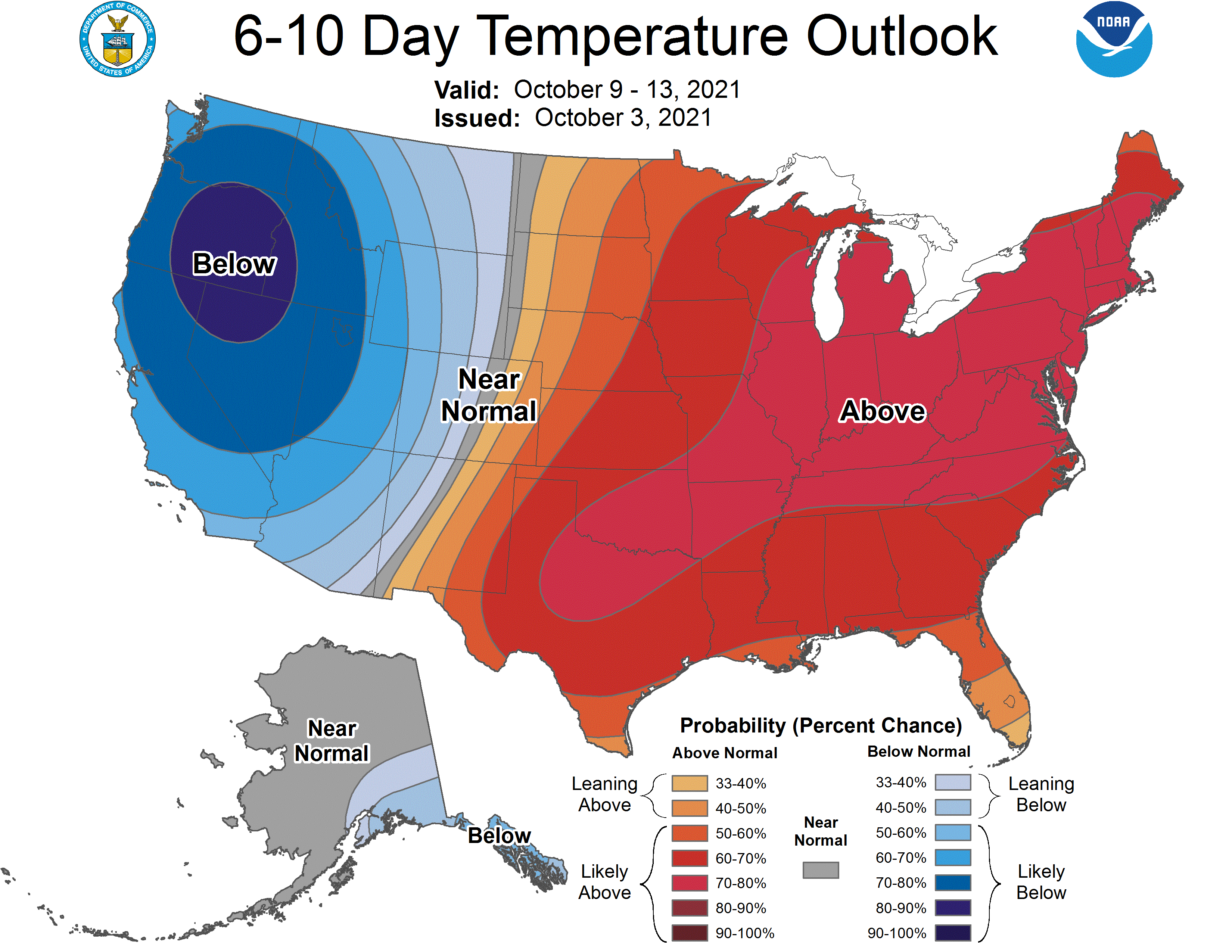
Above-normal temps may linger through next weekend and into the following week. The NWS Climate Prediction Center shows a tendency for above-normal temps in Minnesota and Wisconsin from Oct. 9 through Oct. 13:
Fall colors

The percentage of changeover to fall colors is highest in northern Minnesota right now. Here’s the latest fall color report from the Minnesota Department of Natural Resources:
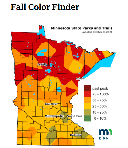
Keep in mind that all deciduous trees are included in the fall color report, not just maples. Wisconsin fall color info can be found here.
There are some pockets of very good fall color elsewhere, including portions of the Twin Cities metro area. We’ll see even more fall color in the days ahead.
Programming note
You can hear my live weather updates on MPR News at 7:35 a.m., 9:35 a.m. and 4:39 p.m. each Saturday and Sunday.

