
Minnesota sees another foggy start Tuesday
The western edge of the state may see highs in the 80s
Go Deeper.
Create an account or log in to save stories.
Like this?
Thanks for liking this story! We have added it to a list of your favorite stories.


Thanks to high pressure over the area, Minnesota can expect another sunny and mild day on Tuesday after areas of dense fog lift.
Tuesday’s forecast
Just like Monday morning, Minnesota is still sitting under a broad ridge of higher pressure, bringing dry and mild weather across the state.
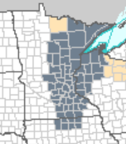
But, also like Monday, the clear skies and light winds overnight provided the conditions for another very foggy morning Tuesday along most of eastern Minnesota.
Because of the thick fog, almost all of eastern Minnesota is under a dense fog advisory until 10 a.m., with many spots seeing visibility reduced to a quarter mile or lower.
This does include the Twin Cities, however, as of 7 a.m., the fog reports around the metro have not been as dense as Monday.
Turn Up Your Support
MPR News helps you turn down the noise and build shared understanding. Turn up your support for this public resource and keep trusted journalism accessible to all.
Western Minnesota sees sunshine right away Tuesday morning, and the rest of the state turns sunny as the fog lifts. Because of the additional sunshine, western Minnesota will have the warmer highs again Tuesday.
Most of the state is starting Tuesday in the 40s and 50s.
Highs will range from the lower 70s east, to a few 80s near the western edge of the state.
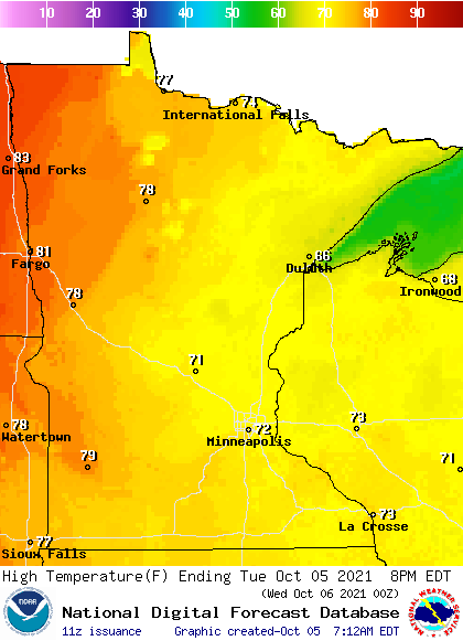
The warm weather continues most of the week, with rain returning to the state by Thursday.
That extended forecast will be updated around 9 a.m.
Programming note
You can hear my live weather updates on Minnesota Public Radio at 7:48 a.m. Monday through Friday morning.

