
Warm Sunday, mild Monday; cooler with rain/snow chances later this week
NWS explains snow forecast procedures

Go Deeper.
Create an account or log in to save stories.
Like this?
Thanks for liking this story! We have added it to a list of your favorite stories.


This feels more like early October than early November!
Our average Twin Cities high temp is 46 degrees this time of year. The metro area will top out in the 60s this Sunday, sharing 60s with much of Minnesota and western Wisconsin. A few spots in southwestern Minnesota could top 70. North-central and northeastern Minnesota will see some 50s.
Temperature trends
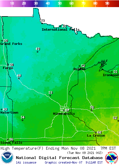
Monday highs will be mainly in the 50s, with some upper 40s in northwestern Minnesota:
Turn Up Your Support
MPR News helps you turn down the noise and build shared understanding. Turn up your support for this public resource and keep trusted journalism accessible to all.
Monday afternoon wind gusts will be in the 14-20 mph range in parts of the west and north:

Forecast gusts are in knots, with 13 knots equal to 15 mph.
Back to temperatures, Twin Cities high temps are projected to reach the mid 50s Tuesday, followed by lower 50s Wednesday, upper 40s Thursday and then chilly upper 30s on Friday.
Rain/snow potential later this week
Several weather forecast models show a strong low pressure system moving across the upper Midwest from Wednesday into early Friday. The precipitation from that system will probably start out as rain, then transition to wet snow at some point. The timing of the changeover to snow will depend on the exact track, speed and strength of the low pressure system.
The National Oceanic and Atmospheric Administration’s Global Forecast System (GFS) shows the potential precipitation pattern from Wednesday through Friday:
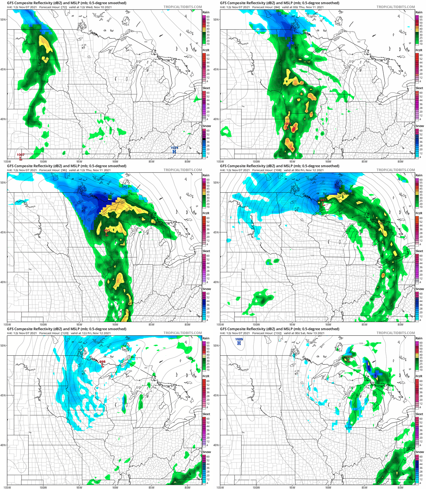
The GFS forecast model shows the quickest changeover to snow in the northern third of Minnesota, with the potential for several inches of snow from Wednesday afternoon or evening into early Friday. The GFS model shows a delayed changeover to snow or a rain/snow mix to the south. That would give the Twin Cities and southern Minnesota much lower snow accumulations. Check forecast updates as we get closer to Wednesday and Thursday.
You can hear updated weather information for Minnesota and western Wisconsin on the Minnesota Public Radio News network, and you can see updated weather info on the MPR News live weather blog.
Why snow forecasts get better with time
Don’t pay too much attention to forecast snow totals four or five days into the future.
The Duluth office of the National Weather Service has an excellent explanation of why snow forecasts are much more accurate as we get closer to the event:
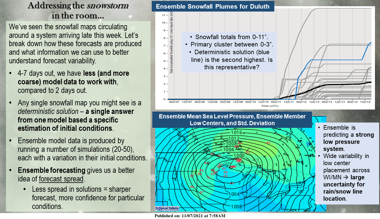
Here is the text that accompanied the NWS graphic:
We've seen a lot going around social media about a “massive snowstorm!” coming late this work week, so we thought it might be worth addressing winter-time forecasting and what kind of data we are working with when forecasting for the extended forecast period (beyond 3 days or so). At 4-7 days out, we have much less model data to work with compared to 1-3 days away from the event. This is because higher-resolution models are run out to a shorter time period. For an event coming on Thursday-Friday, on Sunday morning we have global model data to work with, such as the GFS (American), ECMWF (European), and GEM (Canadian) – these models are more coarse spatially and temporally (the GFS model has a grid spacing of 18 miles versus a higher-res model like the HRRR which is on 1.9 mile grids). Each model will produce a deterministic solution, which is just a single forecast answer based on a particular estimate of initial conditions. One way to better understand different forecast variability is to use ensemble forecasting, where a collection of forecast simulations are run, each with a slight variation in the initial conditions, which will produce differences through the forecast period. The spread amongst all these solutions allows us to better understand the range of possible conditions. The less spread between ensemble predicted outcomes, the “sharper” a forecast is and the greater confidence we can have in the forecast we produce! There are a number of ways to visualize ensemble data, we've presented two in this image. The answer that we glean from these? There is a ton of variability left for this week's system. It will most likely precipitate, but how much, what kind of precipitation it will be, and where the axis of heaviest accumulation will be is still very up in the air.
Very warm one year ago today
One year ago, we set a new Nov. 7 record high in the Twin Cities, hitting 74 degrees. Three days later, we had a Twin Cities high of 32 degrees and 5.5 inches of fresh snow!
Programming note
You can hear my live weather updates on MPR News at 7:35 a.m., 9:35 a.m. and 4:39 p.m. each Saturday and Sunday.

