
Snow spreads across Minnesota and western Wis. Saturday afternoon/evening
Low visibilities and slick spots are expected
Go Deeper.
Create an account or log in to save stories.
Like this?
Thanks for liking this story! We have added it to a list of your favorite stories.


Blog updated at 1:30 p.m. with winter weather advisory
Most of the Twin Cities metro area missed out on the accumulating snow that hit western and northern Minnesota Thursday and Friday, but this Saturday’s storm system will include the metro area in its swath of snow.
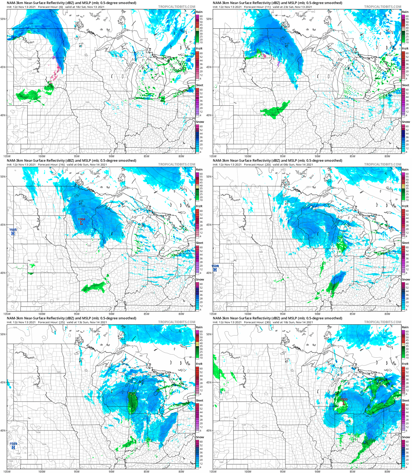
The National Oceanic and Atmospheric Administration’s North American Mesoscale (NAM) forecast model shows the potential precipitation pattern from noon Saturday to noon Sunday:
NOAA’s High-Resolution Rapid-Refresh (HRRR) forecast model shows a similar snow pattern:
Turn Up Your Support
MPR News helps you turn down the noise and build shared understanding. Turn up your support for this public resource and keep trusted journalism accessible to all.
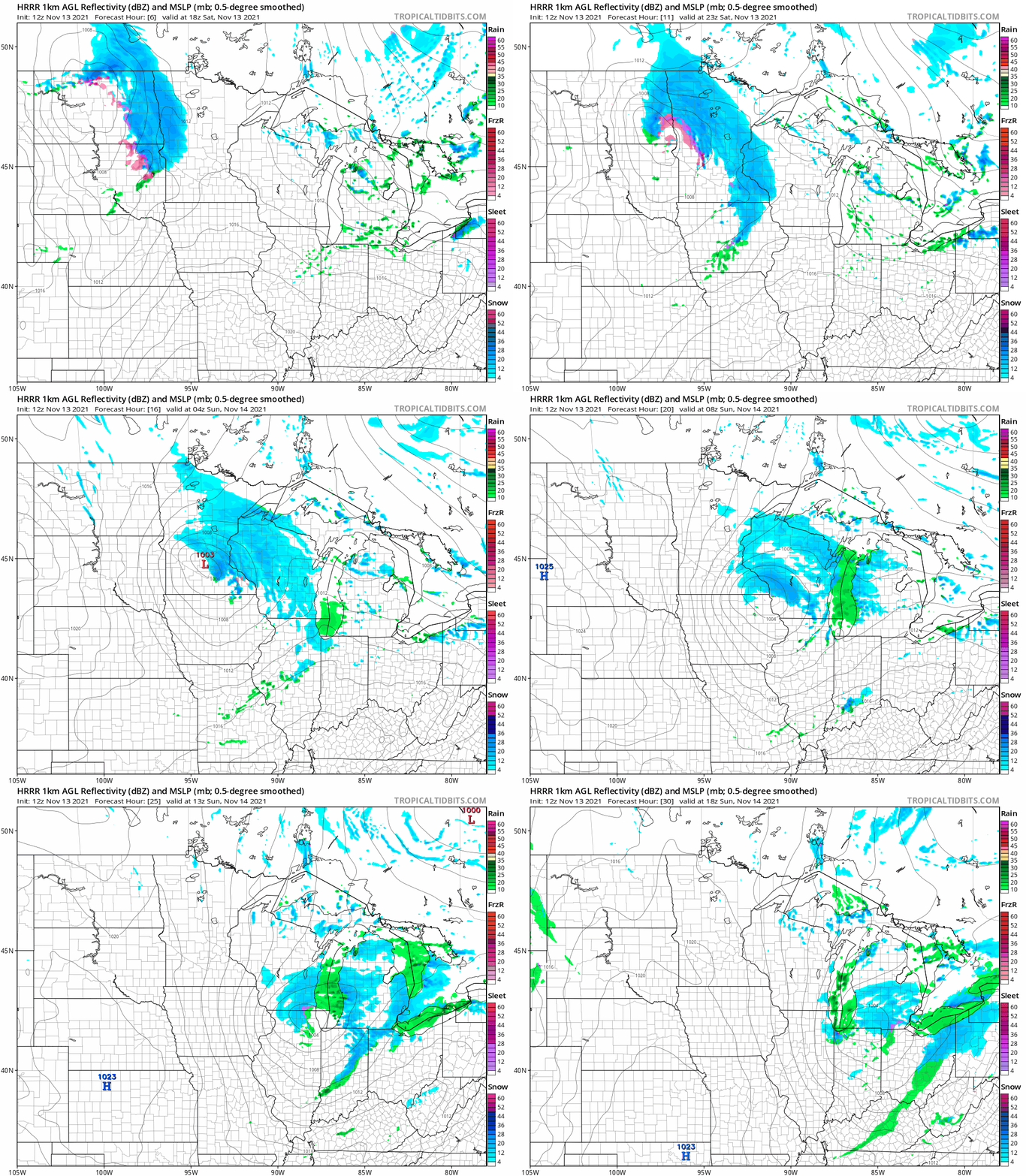
There could also be a bit of spotty light rain/drizzle and light freezing rain/freezing drizzle at times.
Snow will begin in western Minnesota first, then spread eastward, possibly arriving in the Twin Cities around 2 or 3 p.m. and lasting through the evening.
You can hear updated weather information for Minnesota and western Wisconsin on the Minnesota Public Radio News network, and you can see updated weather info on the MPR News live weather blog.
Potential snow totals
Metro snow totals may range from around one inch in the far south metro to as high as 2 to 3 inches in the far north and northeast metro:

Heavier snow is expected in parts of central and northern Minnesota.
____________________________________________________________________________________________
Update: a winter weather advisory begins at 3 p.m. this Saturday and continues until 6 a.m. Sunday for the central and northern sections of the Twin Cities metro area:
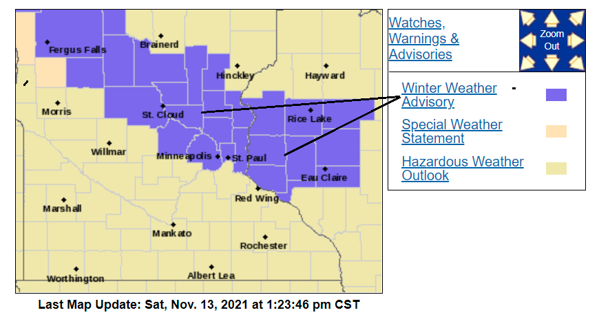
Here are details of the winter weather advisory, from the NWS:
URGENT - WINTER WEATHER MESSAGE National Weather Service Twin Cities/Chanhassen MN 113 PM CST Sat Nov 13 2021 MNZ045-052-053-060>063-WIZ014>016-023>028-140415- /O.NEW.KMPX.WW.Y.0011.211113T2100Z-211114T1200Z/ Kanabec-Isanti-Chisago-Hennepin-Anoka-Ramsey-Washington-Polk- Barron-Rusk-St. Croix-Pierce-Dunn-Pepin-Chippewa-Eau Claire- Including the cities of Mora, Cambridge, Center City, Minneapolis, Blaine, St Paul, Stillwater, Osceola, Rice Lake, Ladysmith, Hudson, River Falls, Menomonie, Durand, Chippewa Falls, and Eau Claire 113 PM CST Sat Nov 13 2021 ...WINTER WEATHER ADVISORY IN EFFECT UNTIL 6 AM CST SUNDAY... * WHAT...Snow expected. Total snow accumulations of 2 to 4 inches. * WHERE...Portions of northwest and west central Wisconsin and east central Minnesota. * WHEN...Until 6 AM CST Sunday. * IMPACTS...Plan on slippery road conditions. * ADDITIONAL DETAILS... Snow could reduce visibility below a half mile at times. The first burst of snow will last a couple hours this afternoon before a lull in precipitation. A second round of snow will begin this evening and continue overnight. PRECAUTIONARY/PREPAREDNESS ACTIONS... Slow down and use caution while traveling. The latest road conditions for the state you are calling from can be obtained by calling 5 1 1. Road conditions can also be found at 511mn.org for Minnesota or 511wi.gov for Wisconsin.
The winter weather advisory is already in effect for counties in central Minnesota.
Snow is already causing travel problems in western Minnesota:
___________________________________________________________________________________________
Here’s the northwestern Minnesota snow forecast:

The areas of North Dakota and northwestern Minnesota that are shaded blue in the right panel are in a winter weather advisory. The advisory started Saturday morning and runs to 9 p.m. Saturday evening along the Red River Valley. The advisory starts at noon Saturday and runs to midnight from Thief River Falls to Detroit lakes to Bemidji and Park Rapids.
Here’s the snow forecast for northeastern Minnesota/northwestern Wisconsin:

You can expect reduced visibilities due to snow, There will also be some slippery roads in parts of Minnesota and western Wisconsin due to the snow and patchy freezing drizzle. Check forecast updates.
Temperature trends
Our average Twin Cities high temp is 43 degrees this time of year. We’ll top out in the 30s Saturday afternoon in the Twin Cities and much of Minnesota and western Wisconsin. parts of far northwestern Minnesota will only reach the upper 20s.
Sunday highs will be in the 20s to the north, with 30s elsewhere:
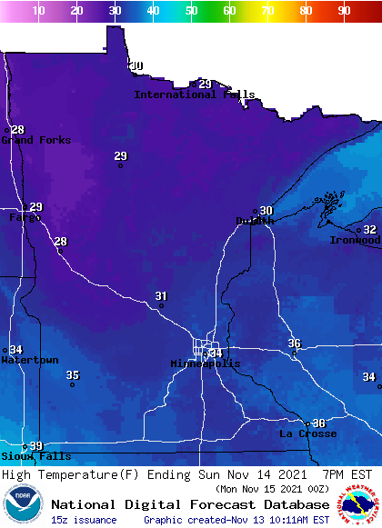
Twin Cities metro area highs are projected to reach the upper 30s Monday, Tuesday will be the warmest day of the week, with a high in the lower 50s, then Twin Cities highs retreat to the mid 30s for Wednesday, followed by upper 30s on Thursday and Friday. We could see some light snow Monday morning, and there is a chance of a rain or snow shower Monday afternoon.
Weather nugget
Our average snow total for the month of November is 6.8 inches in the Twin Cities. We had 8.8 inches of snow last November. The snowiest November in Twin Cities weather records was in 1991, with 46.9 inches.
Programming note
You can hear my live weather updates on MPR News at 7:35 a.m., 9:35 a.m. and 4:39 p.m. each Saturday and Sunday.

