
Lighter winds Saturday; windy & colder on Sunday, with highest flake chances in northern Minn.
No big storms in sight
Go Deeper.
Create an account or log in to save stories.
Like this?
Thanks for liking this story! We have added it to a list of your favorite stories.


Today will be the nicer day of the weekend for outdoor activities. Raking leaves or taking a bike ride is much more enjoyable with lighter winds! We won’t have to lean into the wind as we take a walk today.
Weekend temps and winds
Our average Twin Cities high temp is 40 degrees this time of year. Much of the metro area will see highs in the low and mid 40s this Saturday. Highs in the 40s are expected today from far southern Minnesota into east-central Minnesota and western Wisconsin. Highs in the 30s are expected in Much of northern and central Minnesota.
Saturday wind gusts will be in the 10-16 mph range in many areas. Parts of northeastern Minnesota could see a few gusts over 20 mph.
Turn Up Your Support
MPR News helps you turn down the noise and build shared understanding. Turn up your support for this public resource and keep trusted journalism accessible to all.
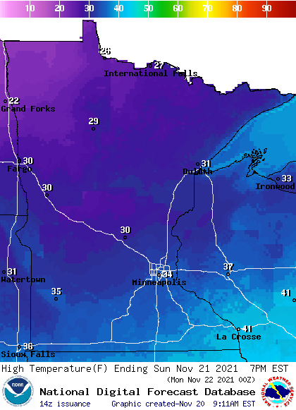
Sunday highs will be mainly in the 30s, with 20s in northwestern and north-central Minnesota:
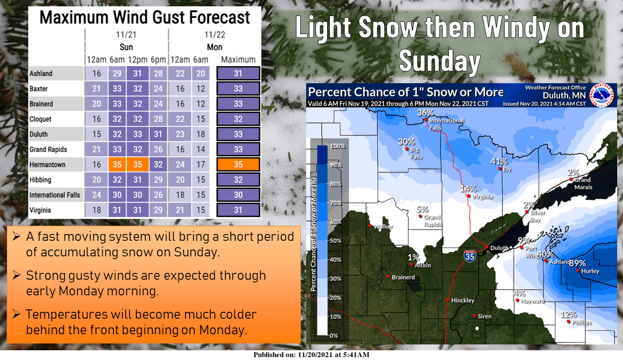
It’ll feel colder than the air temp on Sunday, with wind gusts of 30-40 mph:
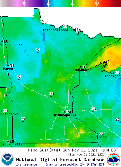
Forecast gusts are in knots, with 28 knots equal to 32.2 mph.
There is a gale watch for Lake Superior from Sunday afternoon into early Monday:
URGENT - MARINE WEATHER MESSAGE National Weather Service Marquette MI 955 AM EST Sat Nov 20 2021 LSZ162-263-202300- /O.CON.KMQT.GL.A.0018.211121T1800Z-211122T1200Z/ Lake Superior west of a line from Saxon Harbor WI to Grand Portage MN beyond 5NM- Lake Superior from Saxon Harbor WI to Upper Entrance to Portage Canal MI 5NM off shore to the US/Canadian border including Isle Royale National Park- 955 AM EST Sat Nov 20 2021 /855 AM CST Sat Nov 20 2021/ ...GALE WATCH REMAINS IN EFFECT FROM SUNDAY AFTERNOON THROUGH MONDAY MORNING... * WHAT...Northwest winds 20 to 30 kt with gusts up to 40 kt and waves 6 to 11 ft possible. * WHERE...Lake Superior west of a line from Saxon Harbor WI to Grand Portage MN beyond 5NM and Lake Superior from Saxon Harbor WI to Upper Entrance to Portage Canal MI 5NM off shore to the US/Canadian border including Isle Royale National Park. * WHEN...From Sunday afternoon through Monday morning. * IMPACTS...Strong winds can cause hazardous waves which could capsize or damage vessels and reduce visibility. PRECAUTIONARY/PREPAREDNESS ACTIONS... Mariners should consider altering plans to avoid possible hazardous conditions. Remain in port, seek safe harbor, alter course, and/or secure the vessel for severe wind and waves.
You can hear updated weather information for Minnesota and western Wisconsin on the Minnesota Public Radio News network, and you can see updated weather info on the MPR News live weather blog.
Sunday flake chance to the north
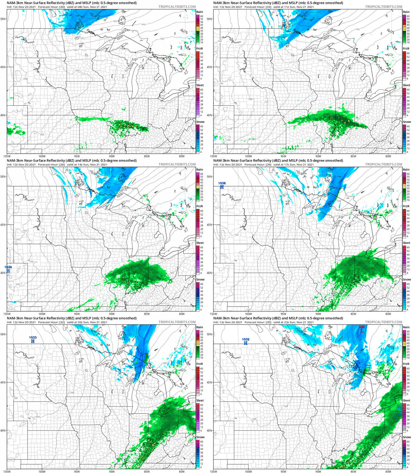
Parts of northern Minnesota and northwestern Wisconsin could see a bit of light snow accumulation on Sunday.
The National Oceanic and Atmospheric Administration’s North American Mesoscale (NAM) forecast model shows the potential precipitation pattern for Sunday:
NOAA’s High-Resolution Rapid-Refresh model shows a similar pattern:
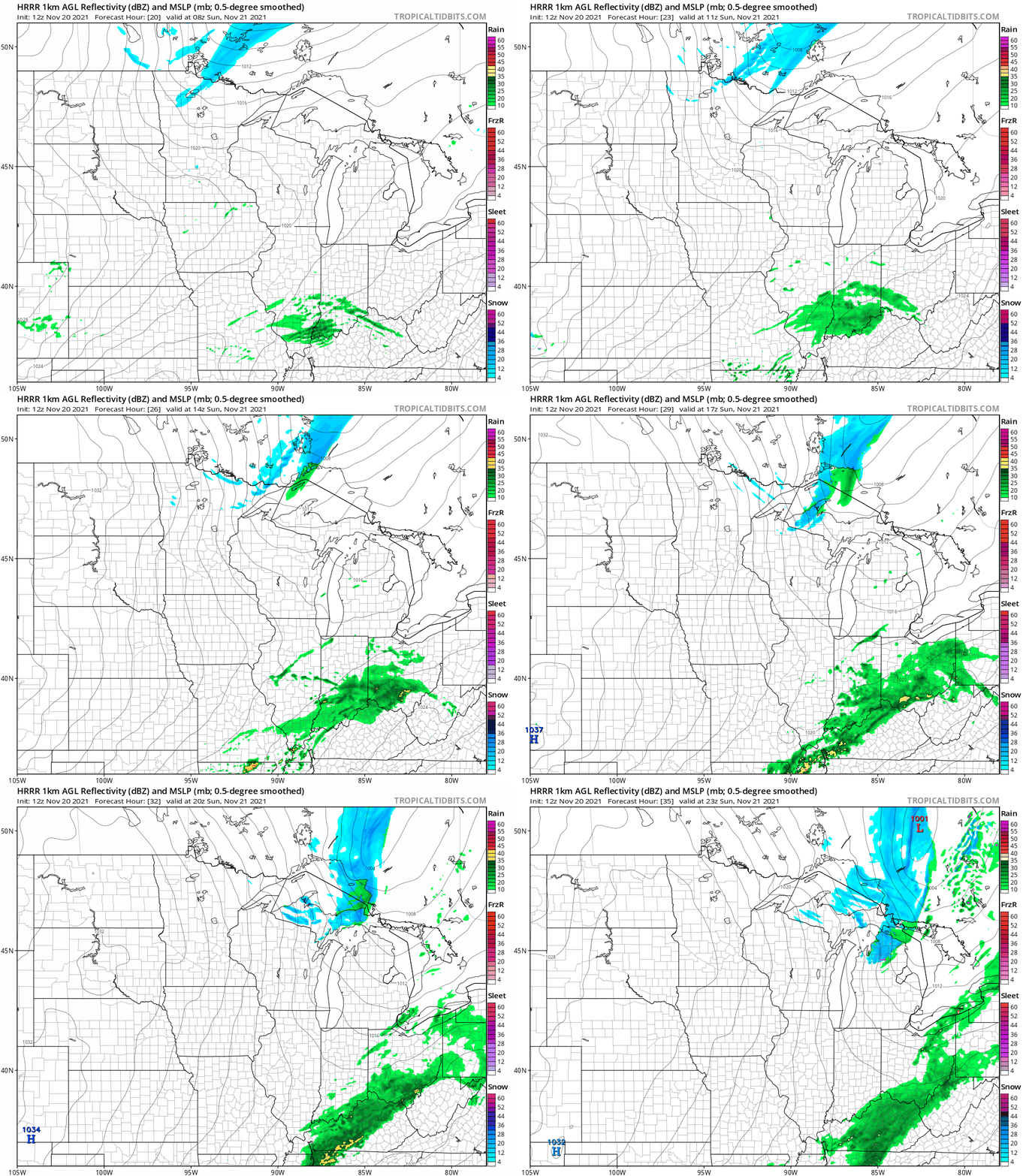
Central Minnesota and the Twin Cities metro area could see a stray flurry Sunday morning.
Here’s the Sunday snow outlook for northern Minnesota and northwestern Wisconsin, from the Duluth NWS office:
The week ahead
Forecast models aren’t showing any big storms in Minnesota or western Wisconsin this coming week. Twin Cities metro area highs are projected to be around 30 degrees on Monday, then we see highs rebound to the mid 40s Tuesday and Wednesday. Highs retreat to around 30 degrees on Thanksgiving, followed by lower 30s on Friday.
Weather nugget
At this point last autumn, we had seen 17.6 inches of snow in the Twin Cities (9.3 inches in Oct. and 8.3” by this point in Nov.). So far this autumn, just 1.2 inches of snow has been measured at MSP airport.
Programming note
You can hear my live weather updates on MPR News at 7:35 a.m., 9:35 a.m. and 4:39 p.m. each Saturday and Sunday.

