
Exceptionally late-season severe weather expected Wednesday
Damaging winds are the primary concern, but isolated tornadoes are possible
Go Deeper.
Create an account or log in to save stories.
Like this?
Thanks for liking this story! We have added it to a list of your favorite stories.


A strong storm poised to track directly over Minnesota Wednesday brings high winds, record temperatures — and a rare December risk for severe weather.
Wednesday’s storm
Following what was already a very mild day on Tuesday, breezy winds from the southeast overnight keep temperatures mostly steady and even warm temperatures a few degrees, especially in southern Minnesota.
Wednesday morning temperatures will be mostly in the 30s with a few 40s south, which puts most of Minnesota over 20 degrees above typical morning lows for mid-December.
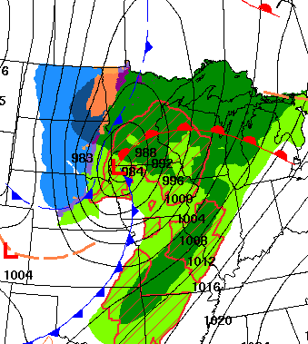
The warm weather Wednesday is ahead of a warm front, that will also produce areas of fog and drizzle Wednesday morning.
Turn Up Your Support
MPR News helps you turn down the noise and build shared understanding. Turn up your support for this public resource and keep trusted journalism accessible to all.
Winds turn gustier through the day Wednesday as the center of the storm approaches Minnesota.
In the warm, windy section of the storm much of Wednesday, most of the state sees highs in the 40s, with some 50s likely in southern Minnesota.
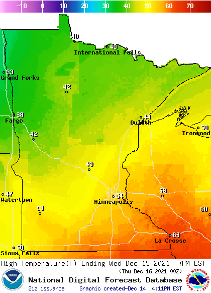
Despite the extensive snowpack in southern Minnesota, which limits the warming somewhat, many new record highs could be set Wednesday including the Twin Cities and Rochester, where the current records for Dec. 15 are 51 and 52 degrees respectively.
Morning drizzle turns to more persistent rain in the afternoon and evening hours, and the dramatic contrast of the warm air ahead of the system and much colder weather behind the storm with help provide the setup for thunderstorms in southern Minnesota.
Some of those storms are expected become severe, with the southern edge of the state under a slight risk area.
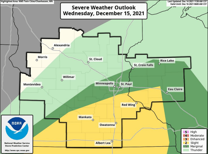
This is tremendously rare for December. The last time Minnesota had a slight risk issued in December was back in 2001. The primary risk is for damaging winds, but isolated tornadoes are possible. If any tornadoes do develop in Minnesota Wednesday, that would crush the previous record for the latest-season tornado in Minnesota. Currently, the state’s latest confirmed tornado for any year was on Nov. 16, 1931.
Even outside of storms, winds will be very strong, with 30 to 40 mph or greater winds for most of the state by evening and through the overnight, and in southeastern Minnesota gusts may top 60 mph.
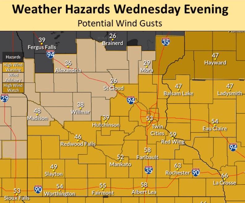
This has all of southern Minnesota under a high wind warning beginning Wednesday afternoon.
Meanwhile, the cold front side of the storm starts pushing into northwestern Minnesota by Wednesday afternoon, dropping temperatures quickly and making more of the precipitation snow.
Northern Minnesota could see up to 4 inches of snow Wednesday into early Thursday.
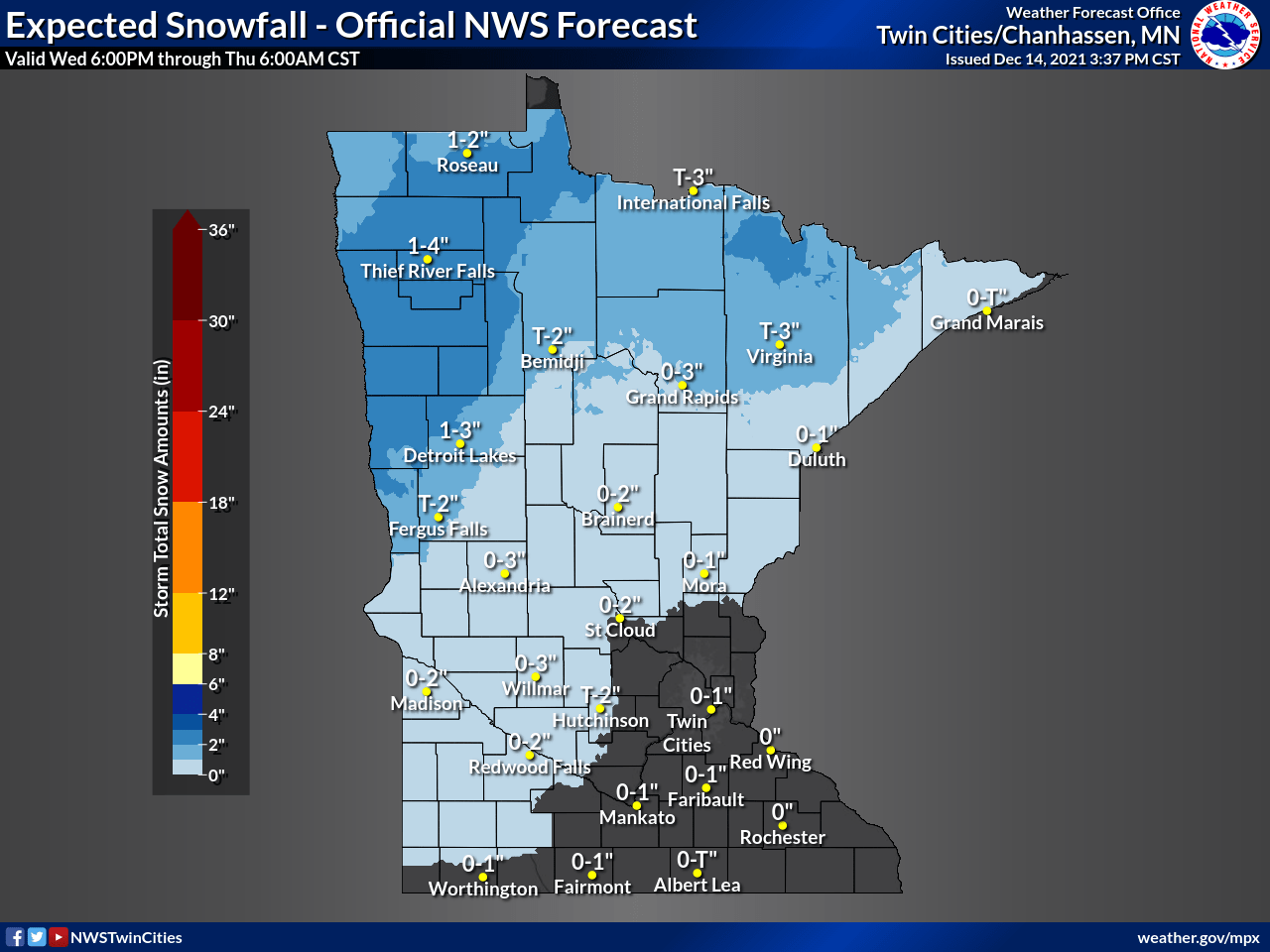
For places that see more of the precipitation as rain, such as the Twin Cities, rainfall of up to an inch is possible in some spots.
Extended forecast
Most of the precipitation ends by early Thursday, and winds diminish quickly during the day. Skies also clear, with more sunshine by Thursday afternoon.
However, the cold front side of the storm also sends temperatures crashing on Thursday. Much of Minnesota will set highs at midnight, coming off the warm day Wednesday, then temperatures will fall into the single-digits north and 20s south by Thursday afternoon.
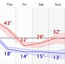
The cooler highs in the teens north and 20s south linger through Saturday, then turns slightly milder again on Sunday with 20s across most of the state and a couple 30s south.
Here is that temperature forecast for the Twin Cities (the Thursday high is the temperature expected at midnight):
Programming note
You can hear my live weather updates on Minnesota Public Radio at 7:49 a.m. Monday through Friday morning.

