
Light snow showers taper off Saturday morning; some slick spots on roads
Cool today
Go Deeper.
Create an account or log in to save stories.
Like this?
Thanks for liking this story! We have added it to a list of your favorite stories.


The snow that spread across much of Minnesota and parts of Wisconsin overnight will linger into Saturday morning.
There are slick spots on some roads this morning. Updated Minnesota road conditions can be found here. Wisconsin road conditions can be found here.
MSP airport reports 1.3 inches of snow so far. As of Friday evening, reports from west-central Minnesota included 3 inches in Wheaton and 4.5 inches in Browns Valley. Snow reports will be posted by the NWS here.
Cool day
Turn Up Your Support
MPR News helps you turn down the noise and build shared understanding. Turn up your support for this public resource and keep trusted journalism accessible to all.
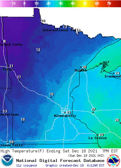
Our average Twin Cities high temp is 28 degrees on Dec. 18. The metro area will reach the lower 20s Saturday afternoon. We’ll share highs in the 20s with roughly the southeastern half of Minnesota plus western Wisconsin, with teens elsewhere:
Saturday wind gusts will be in the 12-18 mph range in many areas, a bit higher in southwestern Minnesota:
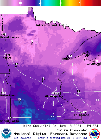
Forecast gusts are in knots, with 14 knots equal to 16.1 mph.
Update
A new updraft blog will be posted around 10:15 a.m. and it’ll include Sunday forecast details plus a look at the week ahead.
Programming note
You can hear my live weather updates on MPR News at 7:35 a.m., 9:35 a.m. and 4:39 p.m. each Saturday and Sunday.

