
Christmas snow totals will be highest in northern Minnesota
Light snow possible in the metro area
Go Deeper.
Create an account or log in to save stories.
Like this?
Thanks for liking this story! We have added it to a list of your favorite stories.


Much of northern and central Minnesota will see some fresh snow this Christmas Day and Christmas evening.
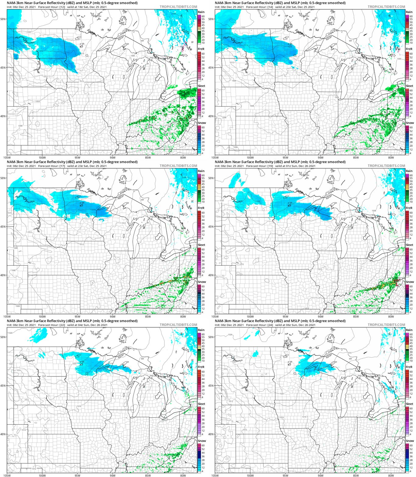
The snow had already moved into portions of west-central and northwestern Minnesota as of 7 a.m., and it’s expected to spread eastward today. The National Oceanic and Atmospheric Administration’s North American Mesoscale (NAM) forecast model shows the potential precipitation pattern for Saturday afternoon and evening:
NOAA’s High-Resolution Rapid-Refresh (HRRR) model shows a similar pattern:
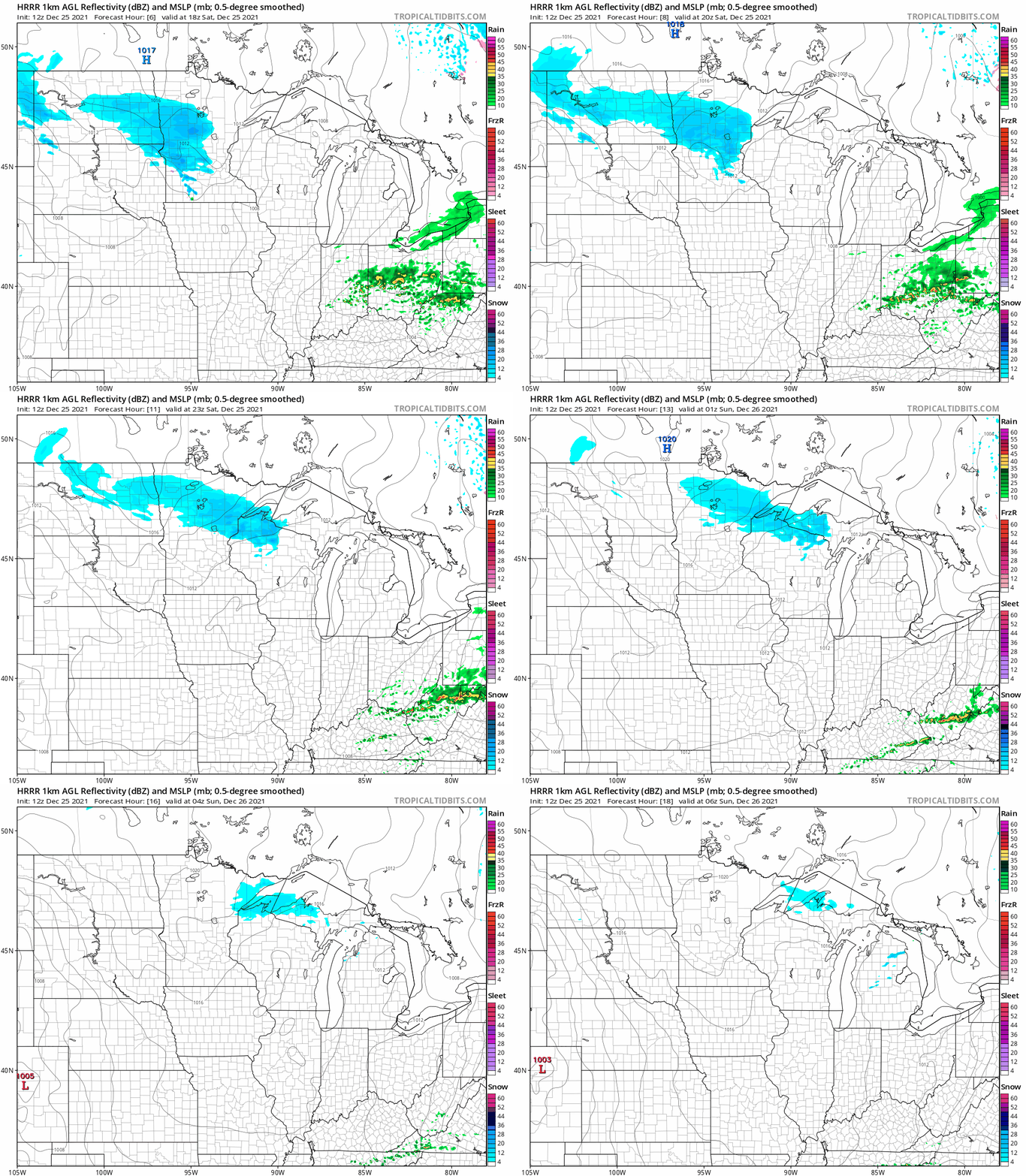
The Twin Cities metro area will be near the southern edge of the snow pattern, with some light snow possible late this morning and this afternoon.
Turn Up Your Support
MPR News helps you turn down the noise and build shared understanding. Turn up your support for this public resource and keep trusted journalism accessible to all.
You can hear updated weather information for Minnesota and western Wisconsin on the Minnesota Public Radio News network, and you can see updated weather info on the MPR News live weather blog.
Snow amounts?
Saturday snow amounts are expected to be highest in the north. Here’s the NWS snow forecast for Saturday:

A winter weather advisory continues until 6 p.m. this Christmas Day in the areas where heaviest snow amounts are expected:
URGENT - WINTER WEATHER MESSAGE National Weather Service Grand Forks ND 735 AM CST Sat Dec 25 2021 MNZ027-030-031-280000- /O.CON.KFGF.WW.Y.0016.211225T1500Z-211226T0000Z/ /O.CON.KFGF.WS.A.0003.211226T2100Z-211228T0000Z/ West Becker-West Otter Tail-East Otter Tail- Including the cities of Detroit Lakes, Fergus Falls, Perham, New York Mills, Parkers Prairie, Henning, and Battle Lake 735 AM CST Sat Dec 25 2021 ...WINTER WEATHER ADVISORY REMAINS IN EFFECT UNTIL 6 PM CST THIS EVENING... ...WINTER STORM WATCH REMAINS IN EFFECT FROM SUNDAY AFTERNOON THROUGH MONDAY AFTERNOON... * WHAT...For the Winter Weather Advisory, snow expected. Total snow accumulations of 2 to 5 inches, with localized higher amounts possible. For the Winter Storm Watch, heavy snow of greater than 6 inches possible. * WHERE...West Becker, West Otter Tail and East Otter Tail Counties. * WHEN...For the Winter Weather Advisory, until 6 PM CST this evening. For the Winter Storm Watch, from Sunday afternoon through Monday afternoon. * IMPACTS...Travel could be very difficult. PRECAUTIONARY/PREPAREDNESS ACTIONS... Slow down and use caution while traveling. Monitor the latest forecasts for updates on this situation. The latest road conditions for North Dakota can be found at dot.nd.gov/travel and for Minnesota at 511mn.org, or by calling 5 1 1 in either state.
I’ll take a look at the Sunday winter storm watch for portions of northern Minnesota in the Updraft update around 10 a.m. today.
Northeastern Minnesota forecast snow amounts for today look like this:

Cooler today
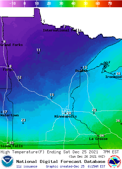
Our average Twin Cities high temp is 26 degrees this time of year. Many spots in the metro area will see highs in the mid 20s today. Minnesota highs will range from the single digits in far northwestern Minnesota to lower 30s just north of the Iowa border:
Saturday midday wind gusts will be in the 10 to 16 mph range in many areas:
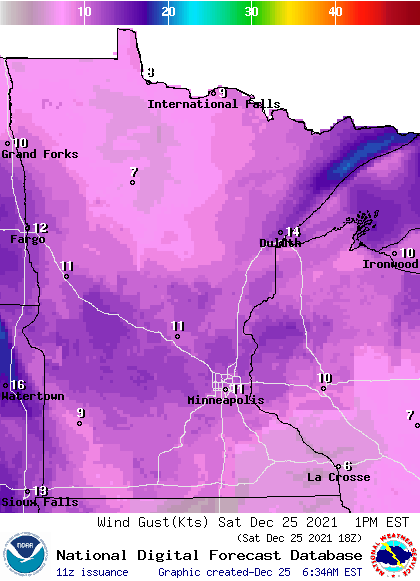
Forecast wind gusts are in knots, with 11 knots equal to 12.7 mph. Some areas near Lake Superior could see a few gusts over 20 mph.
Update
A new Updraft will be posted around 10 a.m. with a look at the potential for significant snow in parts of Minnesota Sunday afternoon and evening plus a look at the week ahead.

