
Winter storm will begin Sunday evening in many areas
Heaviest snow is expected in northern Minnesota
Go Deeper.
Create an account or log in to save stories.
Like this?
Thanks for liking this story! We have added it to a list of your favorite stories.


Some spots in Minnesota saw fresh snow on Christmas, and more snow is on the way.
Ashby and Breckenridge in west-central Minnesota tallied 4 inches of fresh snow by midday on Saturday, with 3 inches in Fergus Falls. Additional snow reports can be found on the NWS 24-hour snow map.
Snow will continue into Saturday evening in portions of northern Minnesota and northwestern Wisconsin. Updated Minnesota road conditions can be found here. Wisconsin road conditions can be found here.
You can hear updated weather information for Minnesota and western Wisconsin on the Minnesota Public Radio News network, and you can see updated weather info on the MPR News live weather blog.
Turn Up Your Support
MPR News helps you turn down the noise and build shared understanding. Turn up your support for this public resource and keep trusted journalism accessible to all.
Winter storm Sunday p.m. into Monday
A winter storm is headed our way for Sunday afternoon and evening into early Monday.
The National Oceanic and Atmospheric Administration’s North American Mesoscale (NAM) forecast model shows the potential precipitation pattern for Sunday afternoon through Monday morning:
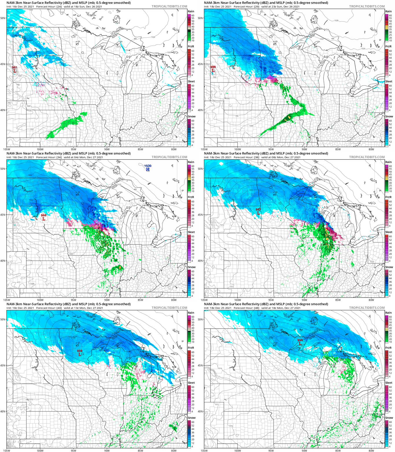
The snow continues into Monday afternoon in parts of far northern Minnesota.
NOAA’s High-Resolution Rapid-Refresh (HRRR) model shows a similar overall pattern, but it moves the snow out of Minnesota by noon on Monday:
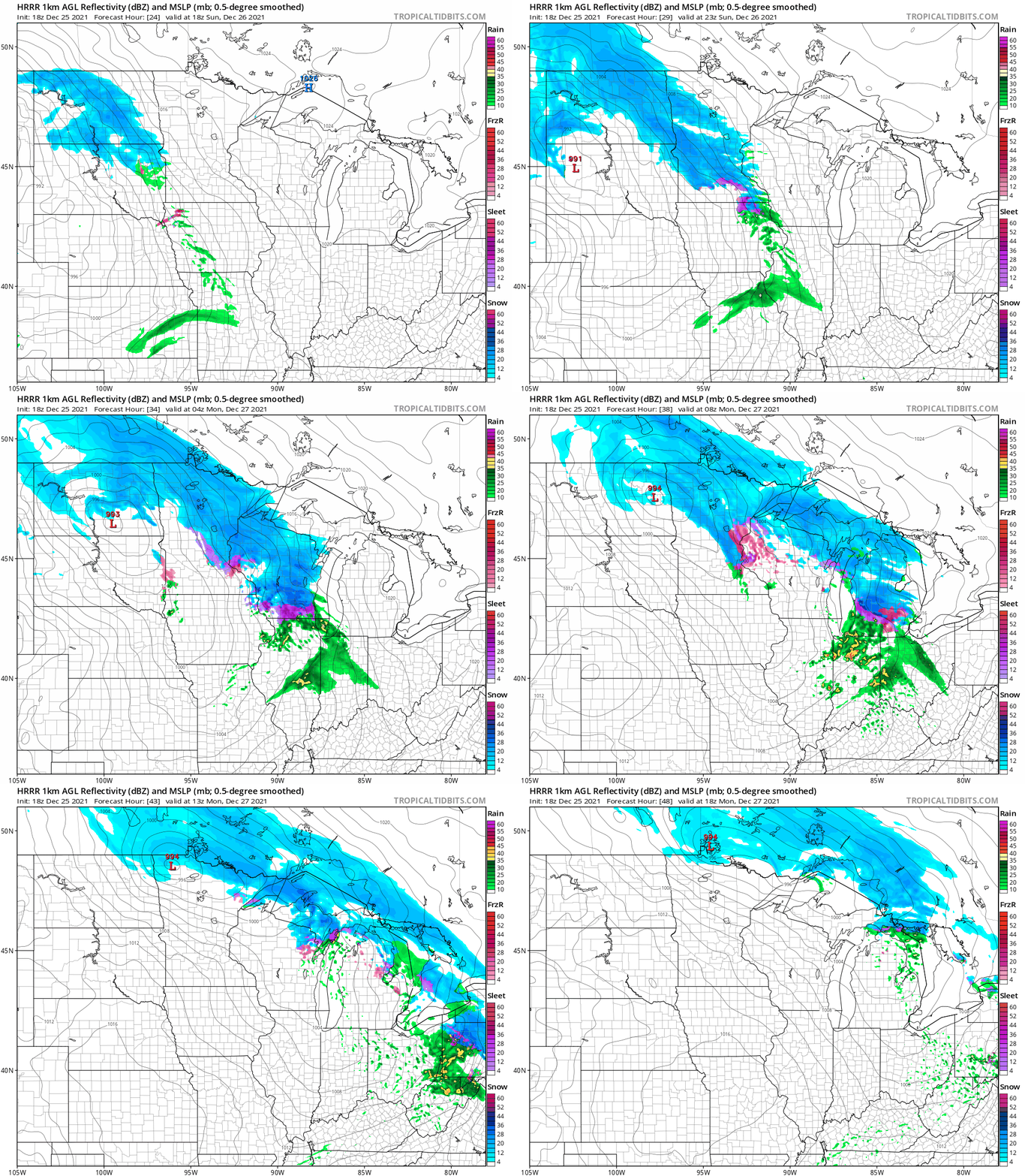
The Twin Cities metro area and southern Minnesota could see a wintry mix in addition to the snow. Early estimates of snow in the Twin Cities metro area from Sunday evening into early Monday are in the 2 to 4 inch range. Check forecast updates on Sunday.
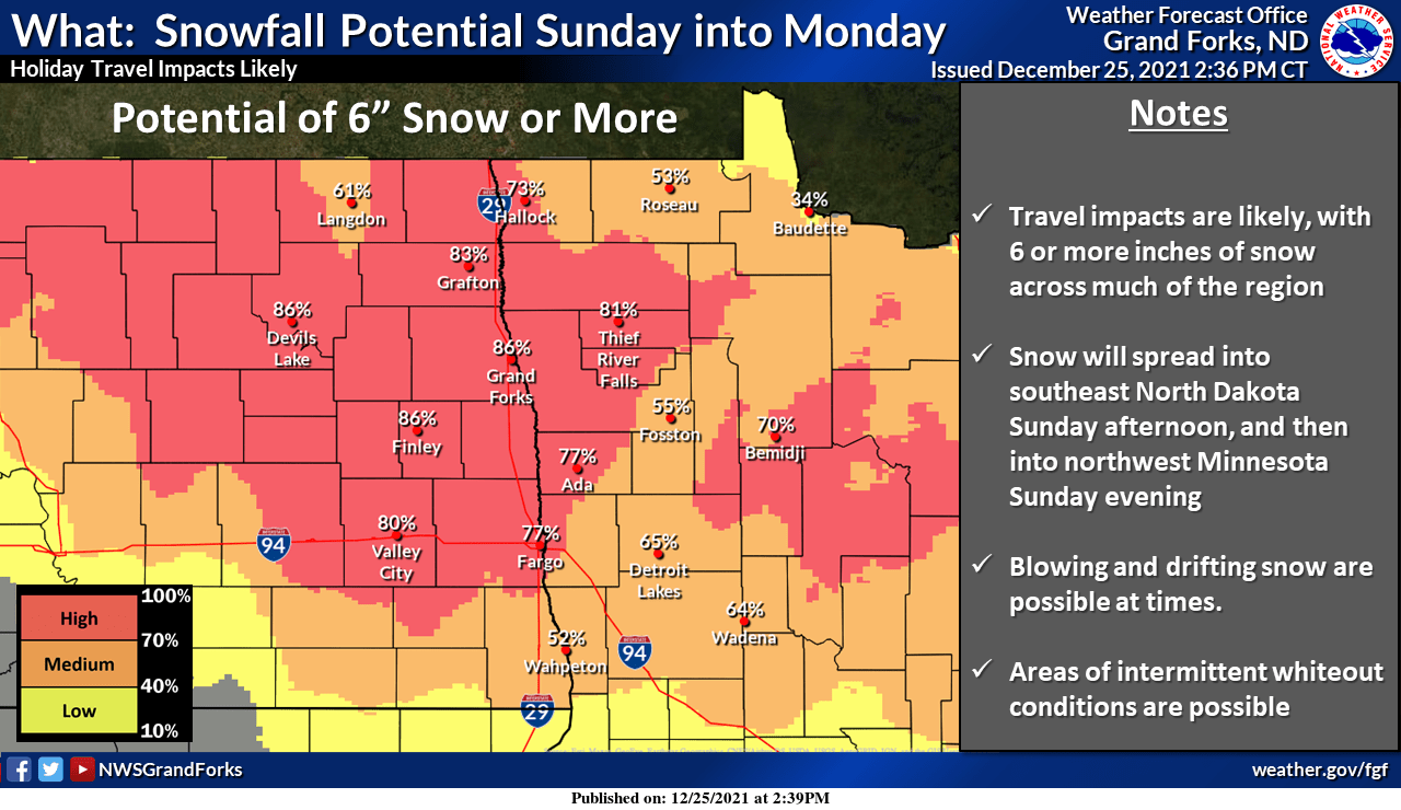
Portions of northwestern Minnesota could see 6 inches or more of snow: from Sunday evening into Monday:
Here are NWS probabilities for heavy snow in northeastern Minnesota and northwestern Wisconsin from late Sunday through Monday:

This is the NWS forecast of snow totals from Sunday evening through Monday in northeastern Minnesota and northwestern Wisconsin:

Winter storm watches
A winter storm watch begins Sunday evening and runs into Monday afternoon in much of northeastern Minnesota and northwestern Wisconsin:

The winter storm watch begins Sunday afternoon for portions of central Minnesota.
Here are winter storm watch details for northeastern Minnesota:
URGENT - WINTER WEATHER MESSAGE National Weather Service Duluth MN 339 PM CST Sat Dec 25 2021 MNZ010>012-018>021-025-026-033>038-WIZ001-002-260945- /O.CON.KDLH.WS.A.0007.211227T0000Z-211228T0000Z/ Koochiching-North St. Louis-Northern Cook and Lake-North Itasca- Central St. Louis-Southern Lake-Southern Cook-North Cass- South Itasca-South Cass-Crow Wing-Northern Aitkin-South Aitkin- Carlton and South St. Louis-Pine-Douglas-Bayfield- Including the cities of International Falls, Ely, Isabella, Bigfork, Hibbing, Two Harbors, Silver Bay, Grand Marais, Walker, Grand Rapids, Pine River, Brainerd, Hill City, Aitkin, Duluth, Pine City, Hinckley, Superior, Washburn, and Bayfield 339 PM CST Sat Dec 25 2021 ...WINTER STORM WATCH REMAINS IN EFFECT FROM SUNDAY EVENING THROUGH MONDAY AFTERNOON... * WHAT...Heavy snow possible. Total snow accumulations of 5 to 9 inches possible, except 10 to 13 inches for the higher terrain of the North Shore possible. Winds could gust as high as 35 mph. * WHERE...Portions of northwest Wisconsin and east central, north central and northeast Minnesota. * WHEN...From Sunday evening through Monday afternoon. * IMPACTS...Travel could be very difficult. Patchy blowing snow could significantly reduce visibility. The hazardous conditions could impact the morning or evening commute. PRECAUTIONARY/PREPAREDNESS ACTIONS... Monitor the latest forecasts for updates on this situation.
A winter storm watch begins Sunday evening across northwestern Minnesota. Here are the winter storm watch details:
URGENT - WINTER WEATHER MESSAGE National Weather Service Grand Forks ND 244 PM CST Sat Dec 25 2021 MNZ004>009-013>017-022>024-032-280000- /O.EXT.KFGF.WS.A.0003.211227T0000Z-211228T0000Z/ Kittson-Roseau-Lake Of The Woods-West Marshall-East Marshall- North Beltrami-Pennington-Red Lake-East Polk-North Clearwater- South Beltrami-Mahnomen-South Clearwater-Hubbard-Wadena- Including the cities of Hallock, Karlstad, Lancaster, Roseau, Warroad, Greenbush, Baudette, Warren, Stephen, Argyle, Newfolden, Middle River, Grygla, Red Lake, Redby, Ponemah, Thief River Falls, Red Lake Falls, Fosston, Fertile, McIntosh, Erskine, Bagley, Clearbrook, Bemidji, Mahnomen, Naytahwaush, Waubun, Alida, Ebro, Lake Itasca, Long Lost Lake, Lower Rice Lake, Roy Lake, Upper Rice Lake, Park Rapids, Wadena, and Menahga 244 PM CST Sat Dec 25 2021 ...WINTER STORM WATCH NOW IN EFFECT FROM SUNDAY EVENING THROUGH MONDAY AFTERNOON... * WHAT...Heavy snow of greater than 6 inches possible. * WHERE...Portions of central, north central and northwest Minnesota. * WHEN...From Sunday evening through Monday afternoon. * IMPACTS...Travel could be very difficult. PRECAUTIONARY/PREPAREDNESS ACTIONS... Monitor the latest forecasts for updates on this situation.
I expect the watch to be upgraded to winter storm warnings for portions of northern and central Minnesota plus parts of Wisconsin in later forecasts.
Temperature trends
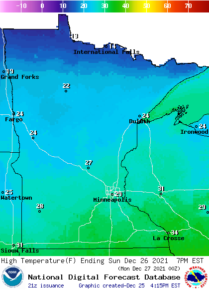
Our average Twin Cities high temp is 26 degrees on Dec. 26. The metro area will see highs close to 30 on Sunday. Highs will range from teens in far northern Minnesota to 30s in the far southeast Sunday afternoon:
Sunday midday wind gusts will be in the 16 to 24 mph range in many areas:
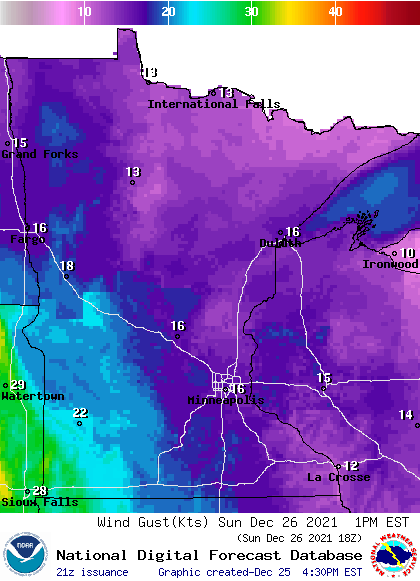
Forecast gusts are in knots, with 16 knots equal to 18.4 mph.
Back to temperatures, Twin Cities metro area highs are projected to reach the mid 20s on Tuesday, followed by single-digit highs on Wednesday and Thursday and then upper teens on Friday.
Chilly start to January
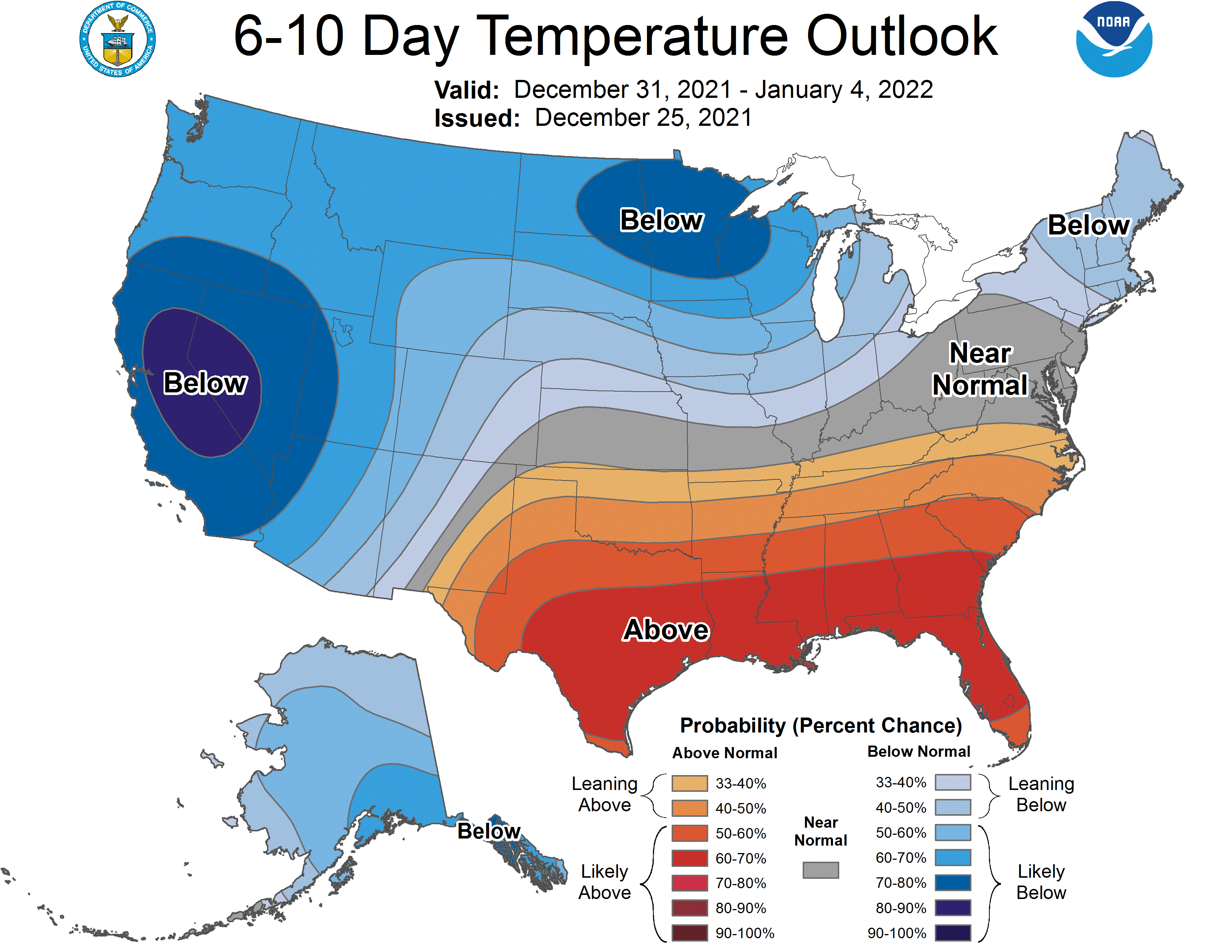
The NWS Climate Prediction Center shows a tendency for below-normal temperatures in Minnesota and Wisconsin from Dec. 31 through Jan. 4:
Programming note
You can hear my live weather updates on MPR News at 7:35 a.m., 9:35 a.m. and 4:39 p.m. each Saturday and Sunday.

