
Winter storm spreads across Minnesota Sunday afternoon and evening
Heaviest snow north
Go Deeper.
Create an account or log in to save stories.
Like this?
Thanks for liking this story! We have added it to a list of your favorite stories.


Get ready for a plowable snow Sunday evening into Monday morning. The snow starts in southwestern Minnesota Sunday afternoon, then spreads northeastward.
The National Oceanic and Atmospheric Administration’s North American Mesoscale (NAM) forecast model shows the potential precipitation pattern for Sunday afternoon through Monday morning:

Accumulating snow may begin in the Twin Cities shortly after sunset.
Snow amounts
Turn Up Your Support
MPR News helps you turn down the noise and build shared understanding. Turn up your support for this public resource and keep trusted journalism accessible to all.
The highest snow amounts are expected over northern Minnesota. Here are NWS snow forecasts:


The Twin Cities metro may see between 2 and 4 inches of snow Sunday evening and overnight, with the highest amounts in the north metro.
You can hear updated weather information for Minnesota and western Wisconsin on the Minnesota Public Radio News network, and you can see updated weather info on the MPR News live weather blog.
Warnings and advisories
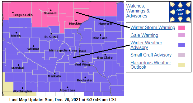
Winter storm warnings cover northern Minnesota and portions of central Minnesota Sunday evening through much of Monday. The warnings begin Sunday afternoon in parts of northwestern Minnesota:


Here are details of the winter storm warning:
URGENT - WINTER WEATHER MESSAGE National Weather Service Duluth MN 646 AM CST Sun Dec 26 2021 MNZ019-037-038-270100- /O.CON.KDLH.WS.W.0008.211227T0000Z-211228T0000Z/ Central St. Louis-Carlton and South St. Louis-Pine- Including the cities of Hibbing, Duluth, Pine City, and Hinckley 646 AM CST Sun Dec 26 2021 ...WINTER STORM WARNING REMAINS IN EFFECT FROM 6 PM THIS EVENING TO 6 PM CST MONDAY... * WHAT...Heavy mixed precipitation expected. Total snow accumulations of 5 to 10 inches and ice accumulations of a light glaze. Winds gusting as high as 40 mph. * WHERE...Pine, Central St. Louis and Carlton and South St. Louis Counties. This includes the Tribal Lands of the Bois Forte Band, Lake Vermilion area, the Fond du Lac Band and the Mille Lacs Band, Lena Lake and, Hinckley areas. * WHEN...From 6 PM this evening to 6 PM CST Monday. * IMPACTS...Travel could be very difficult. Patchy blowing snow could significantly reduce visibility. The hazardous conditions could impact the morning or evening commute. PRECAUTIONARY/PREPAREDNESS ACTIONS... If you must travel, keep an extra flashlight, food, and water in your vehicle in case of an emergency. The latest road conditions can be obtained by calling 5 1 1. Road conditions can also be found at 511mn.org for Minnesota or 511wi.gov for Wisconsin.
Southern Minnesota and the Twin Cities are in a winter weather advisory, which starts at 3 p.m. in southwestern and south-central Minnesota, starting at 6 p.m. elsewhere; including the Twin Cities:
Here are details of the advisory:
URGENT - WINTER WEATHER MESSAGE National Weather Service Twin Cities/Chanhassen MN 324 AM CST Sun Dec 26 2021 ...HEAVY SNOW AND MIXED PRECIPITATION SUNDAY AFTERNOON TO MONDAY MORNING... .A potent winter system is expected to move across Minnesota and western Wisconsin Sunday afternoon into Monday morning with a variety of different winter impacts. The heaviest snow is expected in parts of central Minnesota with 5 to 7 inches expected. The heaviest snow rates are expected tonight. Wind gusts could lead to some patchy blowing snow. Farther south snow is expected to be more in the 2 to 5 inch range. The final impact will be mixed precipitation across southern Minnesota. This mix is most likely later in the event tonight into Monday morning. All together this could lead to a difficult day of travel for those heading home after the holiday. MNZ050-051-059>063-068>070-WIZ023>028-261730- /O.NEW.KMPX.WW.Y.0016.211227T0000Z-211227T1200Z/ Benton-Sherburne-Wright-Hennepin-Anoka-Ramsey-Washington-Carver- Scott-Dakota-St. Croix-Pierce-Dunn-Pepin-Chippewa-Eau Claire- Including the cities of Sauk Rapids, Elk River, Monticello, Minneapolis, Blaine, St Paul, Stillwater, Chanhassen, Chaska, Victoria, Shakopee, Hastings, Hudson, River Falls, Menomonie, Durand, Chippewa Falls, and Eau Claire 324 AM CST Sun Dec 26 2021 ...WINTER WEATHER ADVISORY IN EFFECT FROM 6 PM THIS EVENING TO 6 AM CST MONDAY... * WHAT...Snow expected. Total snow accumulations of 2 to 4 inches. Winds gusting as high as 40 mph. * WHERE...Portions of west central Wisconsin and central and east central Minnesota. * WHEN...From Sunday evening to Monday morning. * IMPACTS...Plan on slippery road conditions. Patchy blowing snow could significantly reduce visibility. PRECAUTIONARY/PREPAREDNESS ACTIONS... Slow down and use caution while traveling. The latest road conditions for the state you are calling from can be obtained by calling 5 1 1. Road conditions can also be found at 511mn.org for Minnesota or 511wi.gov for Wisconsin.
This Updraft blog will be updated around 10 a.m. with additional details, plus a look at some additional snow that’s expected Tuesday afternoon and evening.
Programming note
You can hear my live weather updates on MPR News at 7:35 a.m., 9:35 a.m. and 4:39 p.m. each Saturday and Sunday.

