
Light snow Friday; arctic cold Friday night and through the weekend
Wind chill advisory begins Friday evening

Go Deeper.
Create an account or log in to save stories.
Like this?
Thanks for liking this story! We have added it to a list of your favorite stories.


We’re about to see a familiar winter sequence: snow followed by gusty winds and colder temps.
The National Oceanic and Atmospheric Administration’s North American Mesoscale (NAM) forecast model shows the potential precipitation pattern from 6 a.m. to 6 p.m. Friday:
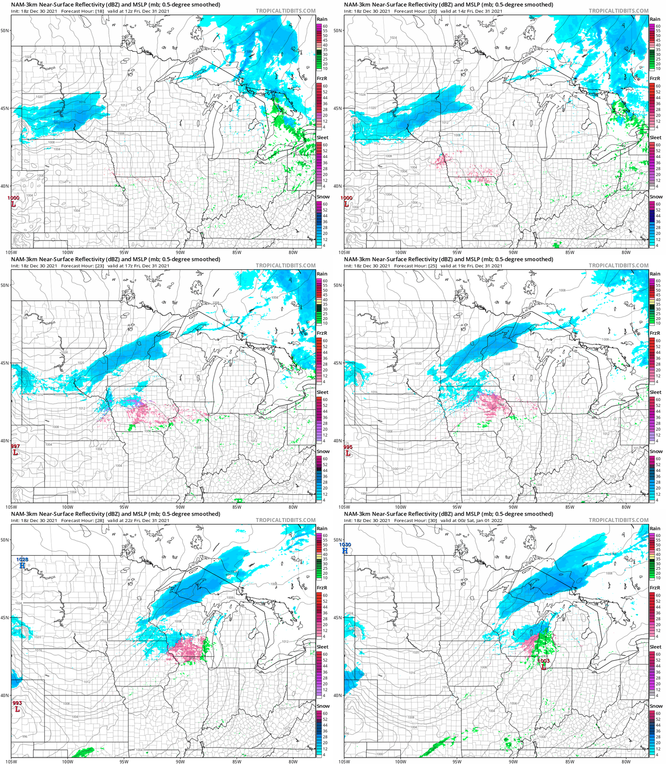
Snow amounts are expected to be less than one inch in most of the areas that see the Friday flakes.
New Year’s Eve temps
Temps at 6 p.m. Friday will range from the teens below zero in northwestern Minnesota to teens above zero in far southeastern Minnesota:
Turn Up Your Support
MPR News helps you turn down the noise and build shared understanding. Turn up your support for this public resource and keep trusted journalism accessible to all.

Twin Cities metro area temps will have fallen into the single digits by 6 p.m. Friday. The time stamp is 7 p.m. EST, which is 6 p.m. CST.
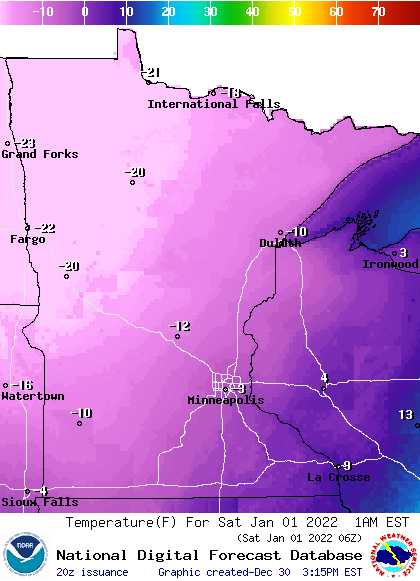
As we welcome the New Year at midnight Friday night, temps will range from the 20s below zero in northwestern Minnesota to single digits below zero in the metro area and southeastern Minnesota:
Gusty winds will give us very cold wind chills Friday evening through Saturday.
The National Weather Service has issued a wind chill advisory for eastern Minnesota and portions of western Wisconsin Friday evening through Saturday morning, with a wind chill warning in parts of western Minnesota:

The wind chill warning in far southwestern Minnesota will continue through Saturday afternoon.
Here are details of the wind chill advisory that includes the Twin Cities metro area from 6 p.m. Friday to noon on Saturday:
URGENT - WINTER WEATHER MESSAGE National Weather Service Twin Cities/Chanhassen MN 248 PM CST Thu Dec 30 2021 MNZ043>045-049>053-057>063-065>070-074>078-082>085-091>093-WIZ014- 015-023-024-311100- /O.NEW.KMPX.WC.Y.0011.220101T0000Z-220101T1800Z/ Morrison-Mille Lacs-Kanabec-Stearns-Benton-Sherburne-Isanti- Chisago-Kandiyohi-Meeker-Wright-Hennepin-Anoka-Ramsey-Washington- Renville-McLeod-Sibley-Carver-Scott-Dakota-Brown-Nicollet- Le Sueur-Rice-Goodhue-Watonwan-Blue Earth-Waseca-Steele-Martin- Faribault-Freeborn-Polk-Barron-St. Croix-Pierce- Including the cities of Little Falls, Princeton, Mora, St Cloud, Sauk Rapids, Elk River, Cambridge, Center City, Willmar, Litchfield, Monticello, Minneapolis, Blaine, St Paul, Stillwater, Olivia, Hutchinson, Gaylord, Chanhassen, Chaska, Victoria, Shakopee, Hastings, New Ulm, St Peter, Le Sueur, Faribault, Red Wing, St James, Mankato, Waseca, Owatonna, Fairmont, Blue Earth, Albert Lea, Osceola, Rice Lake, Hudson, and River Falls 248 PM CST Thu Dec 30 2021 ...WIND CHILL ADVISORY IN EFFECT FROM 6 PM FRIDAY TO NOON CST SATURDAY... * WHAT...Very cold wind chills expected. Wind chills as low as 35 below zero. * WHERE...Portions of northwest and west central Wisconsin and central, east central, south central and southeast Minnesota. * WHEN...From 6 PM Friday to noon CST Saturday. * IMPACTS...The dangerously cold wind chills could cause frostbite on exposed skin in as little as 10 minutes. PRECAUTIONARY/PREPAREDNESS ACTIONS... Use caution while traveling outside. Limit outdoor activities if possible. Wear appropriate clothing, a hat, and gloves.
And here are details of the wind chill warning in western Minnesota, which begins Friday evening:
URGENT - WINTER WEATHER MESSAGE National Weather Service Twin Cities/Chanhassen MN 248 PM CST Thu Dec 30 2021 MNZ041-042-047-048-054>056-064-073-311100- /O.NEW.KMPX.WC.W.0003.220101T0000Z-220101T1800Z/ Douglas-Todd-Stevens-Pope-Lac Qui Parle-Swift-Chippewa- Yellow Medicine-Redwood- Including the cities of Alexandria, Long Prairie, Morris, Glenwood, Madison, Benson, Montevideo, Granite Falls, and Redwood Falls 248 PM CST Thu Dec 30 2021 ...WIND CHILL WARNING IN EFFECT FROM 6 PM FRIDAY TO NOON CST SATURDAY... * WHAT...Dangerously cold wind chills expected. Wind chills as low as 45 below zero. * WHERE...Portions of central, southwest and west central Minnesota. * WHEN...From 6 PM Friday to noon CST Saturday. * IMPACTS...The dangerously cold wind chills could cause frostbite on exposed skin in as little as 10 minutes. PRECAUTIONARY/PREPAREDNESS ACTIONS... Avoid outside activities if possible. When outside, make sure you wear appropriate clothing, a hat, and gloves. Use caution while traveling, and have a winter survival kit packed.
Wind chill warnings are in effect from Thursday evening through Saturday morning in northwestern Minnesota and eastern North Dakota, with wind chill advisories that start Friday evening in north-central Minnesota:

Here are details of the wind chill warning in northwestern Minnesota:
URGENT - WINTER WEATHER MESSAGE National Weather Service Grand Forks ND 308 PM CST Thu Dec 30 2021 MNZ001>005-007-008-013>016-022-023-027>031-040-NDZ006>008-014>016- 024-026>030-038-039-049-052>054-011800- /O.NEW.KFGF.WC.W.0003.211231T0000Z-220101T1800Z/ West Polk-Norman-Clay-Kittson-Roseau-West Marshall-East Marshall- Pennington-Red Lake-East Polk-North Clearwater-Mahnomen- South Clearwater-West Becker-East Becker-Wilkin-West Otter Tail- East Otter Tail-Grant-Towner-Cavalier-Pembina-Benson-Ramsey- Eastern Walsh-Eddy-Nelson-Grand Forks-Griggs-Steele-Traill-Barnes- Cass-Ransom-Sargent-Richland-Western Walsh- Including the cities of Crookston, East Grand Forks, Ada, Twin Valley, Halstad, Moorhead, Hallock, Karlstad, Lancaster, Roseau, Warroad, Greenbush, Warren, Stephen, Argyle, Newfolden, Middle River, Grygla, Thief River Falls, Red Lake Falls, Fosston, Fertile, McIntosh, Erskine, Bagley, Clearbrook, Mahnomen, Naytahwaush, Waubun, Alida, Ebro, Lake Itasca, Long Lost Lake, Lower Rice Lake, Roy Lake, Upper Rice Lake, Detroit Lakes, Wolf Lake, Breckenridge, Fergus Falls, Perham, New York Mills, Parkers Prairie, Henning, Battle Lake, Elbow Lake, Hoffman, Ashby, Herman, Barrett, Cando, Langdon, Cavalier, Walhalla, Drayton, Pembina, Neche, St. Thomas, Fort Totten, Maddock, Leeds, Minnewaukan, Devils Lake, Grafton, Park River, New Rockford, Lakota, Mcville, Aneta, Tolna, Grand Forks, Cooperstown, Finley, Hope, Mayville, Hillsboro, Hatton, Portland, Valley City, Fargo, Lisbon, Enderlin, Gwinner, Milnor, Forman, Rutland, Wahpeton, Edinburg, Adams, and Lankin 308 PM CST Thu Dec 30 2021 ...WIND CHILL WARNING IN EFFECT UNTIL NOON CST SATURDAY... * WHAT...Dangerously cold wind chills expected. Wind chills as low as 55 below zero. * WHERE...Portions of northwest and west central Minnesota and northeast and southeast North Dakota. * WHEN...Until noon CST Saturday. * IMPACTS...The dangerously cold wind chills could cause frostbite on exposed skin in as little as 5 minutes. PRECAUTIONARY/PREPAREDNESS ACTIONS... Avoid outside activities if possible. If outside, make sure you wear appropriate winter clothing.
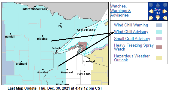
Northeastern Minnesota has wind chill advisories Friday evening through Saturday morning:
You can hear updated weather information for Minnesota and western Wisconsin on the Minnesota Public Radio News network, and you can see updated weather info on the MPR News live weather blog.
Weekend highs and lows
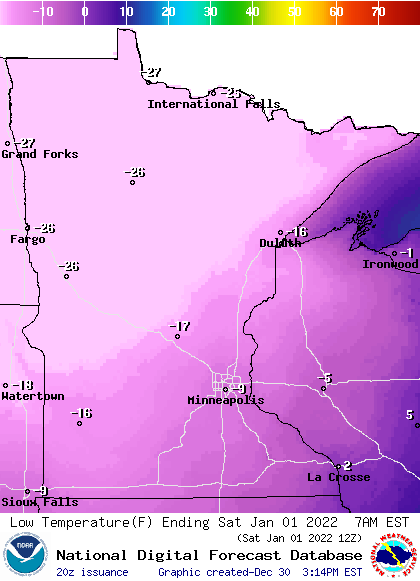
Here are forecast low temps on Saturday:
Saturday forecast highs are all below zero:

Our average Twin Cities high is 25 above zero in New Year’s Day. Our record coldest Twin Cities Jan. 1 high temp was minus 12 in 1974.
Sunday morning lows are expected to be in the 20s below zero in many spots:
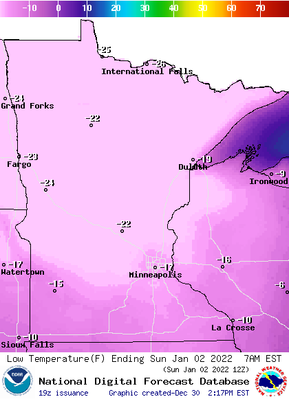
There could even be some 20s below zero early Sunday morning around the outer edges of the Twin Cities metro area.
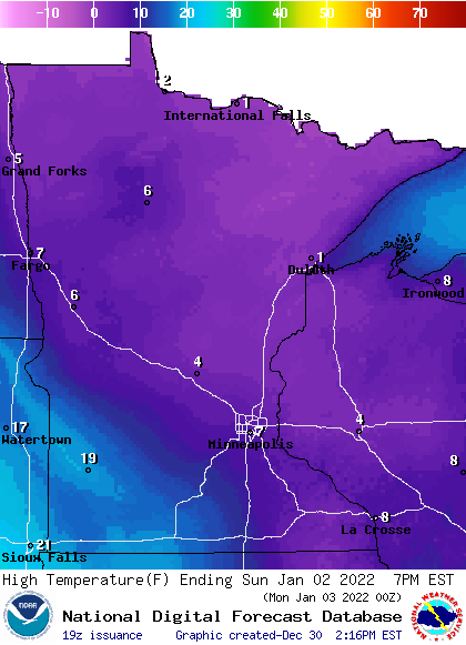
Sunday highs will be in the single digits above zero in many areas, with a few teens in southwestern Minnesota::
Try to stay warm this weekend!
Programming note
You can hear my live weather updates on MPR News at 7:35 a.m., 9:35 a.m. and 4:39 p.m. each Saturday and Sunday.

