
Mildest temps this Saturday; arctic cold returns for Sunday
Cold start to the week, then temps recover
Go Deeper.
Create an account or log in to save stories.
Like this?
Thanks for liking this story! We have added it to a list of your favorite stories.


Saturday will definitely be the milder day of this weekend.
Saturday highs will reach the 20s across much of Minnesota and western Wisconsin, with some lower 30s in far southern Minnesota and teens in the far northwest. Some spots in the metro area will top out in the upper 20s to around 30.
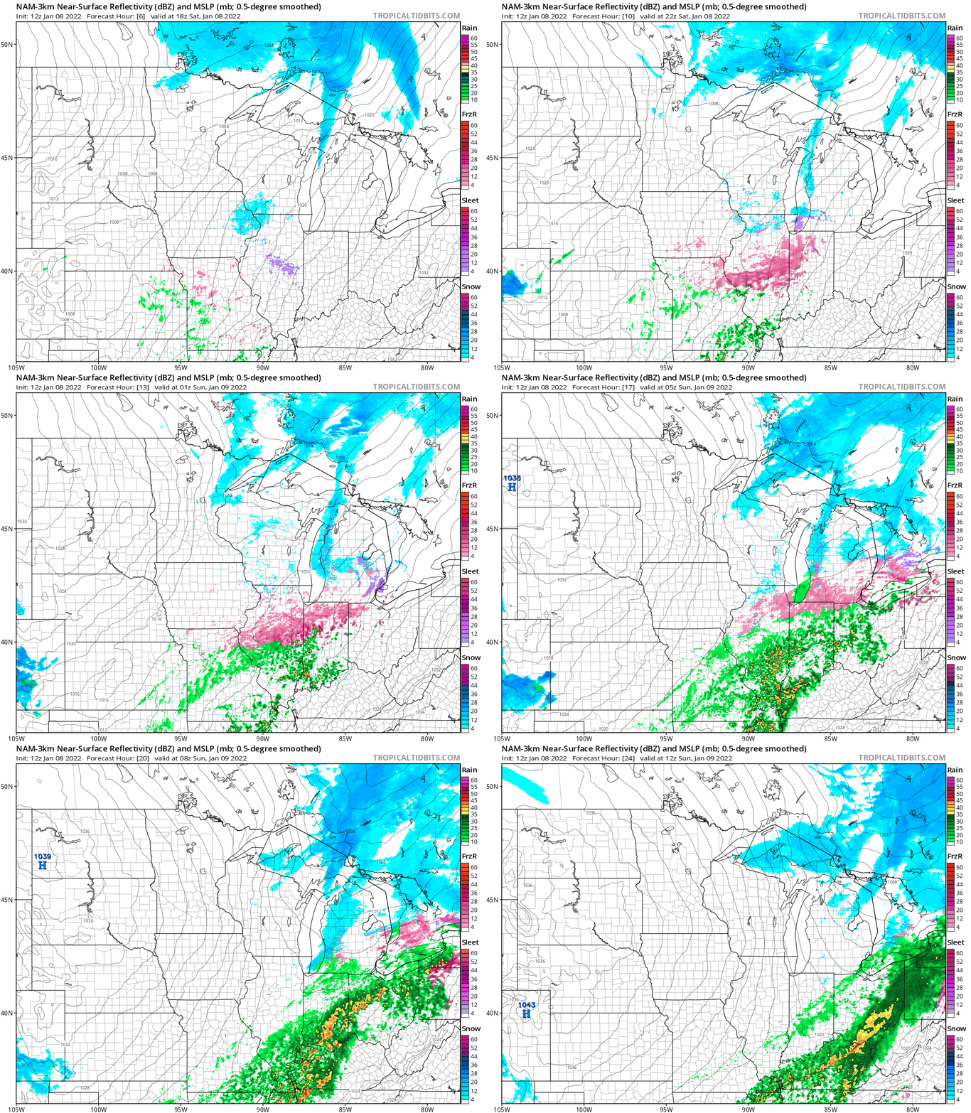
Parts of northern Minnesota could see light snow showers at times this afternoon and evening. The National Oceanic and Atmospheric Administration’s North American Mesoscale (NAM) forecast model shows the potential precipitation pattern from noon Saturday to 6 a.m. Sunday:
A stray flurry is possible elsewhere in Minnesota and western Wisconsin.
Turn Up Your Support
MPR News helps you turn down the noise and build shared understanding. Turn up your support for this public resource and keep trusted journalism accessible to all.
Notice the tight spacing between the isobars to the west Saturday afternoon and evening; that will cause strong winds and low visibilities in North Dakota and parts of far western Minnesota.
Advisories and warnings in North Dakota and near the Red River Valley
Winds will increase today across North Dakota and northwestern Minnesota. Ground blizzard conditions are expected in the portions of North Dakota that are shaded red:
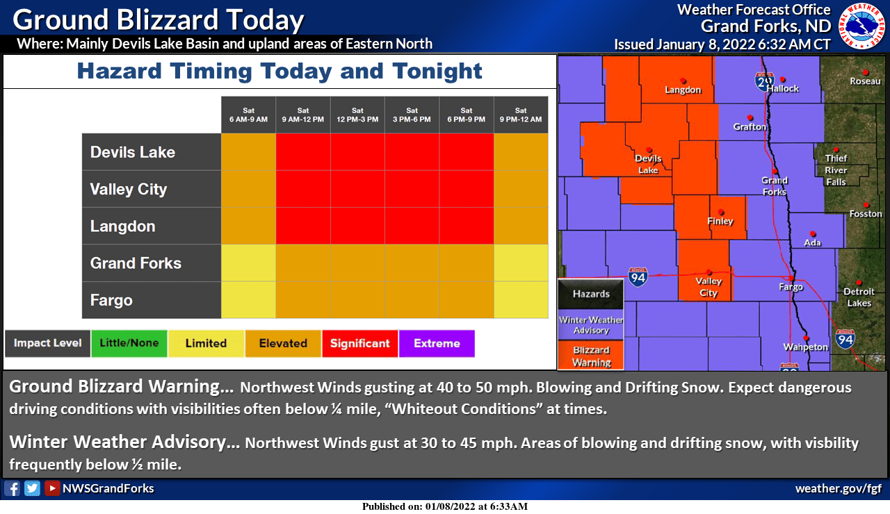
Minnesota counties bordering the Red River are in a winter weather advisory (shaded blue) from 11 a.m. to 9 p.m. this Saturday for blowing snow:
URGENT - WINTER WEATHER MESSAGE National Weather Service Grand Forks ND 338 AM CST Sat Jan 8 2022 MNZ001>004-007-029-NDZ008-016-027-030-039-049-052-053-090300- /O.NEW.KFGF.WW.Y.0003.220108T1700Z-220109T0300Z/ West Polk-Norman-Clay-Kittson-West Marshall-Wilkin-Pembina- Eastern Walsh-Grand Forks-Traill-Cass-Ransom-Sargent-Richland- Including the cities of Crookston, East Grand Forks, Ada, Twin Valley, Halstad, Moorhead, Hallock, Karlstad, Lancaster, Warren, Stephen, Argyle, Breckenridge, Cavalier, Walhalla, Drayton, Pembina, Neche, St. Thomas, Grafton, Park River, Grand Forks, Mayville, Hillsboro, Hatton, Portland, Fargo, Lisbon, Enderlin, Gwinner, Milnor, Forman, Rutland, and Wahpeton 338 AM CST Sat Jan 8 2022 ...WINTER WEATHER ADVISORY IN EFFECT FROM 11 AM THIS MORNING TO 9 PM CST THIS EVENING... * WHAT...Blowing snow expected. Winds gusting as high as 45 mph. * WHERE...The Red River Valley. * WHEN...From 11 AM this morning to 9 PM CST this evening. * IMPACTS...Areas of blowing snow will significantly reduce the visibility, especially in open country. PRECAUTIONARY/PREPAREDNESS ACTIONS... Use caution while traveling, especially in open areas. The latest road conditions for North Dakota can be found at dot.nd.gov/travel and for Minnesota at 511mn.org, or by calling 5 1 1 in either state.
You can hear updated weather information for Minnesota and western Wisconsin on the Minnesota Public Radio News network, and you can see updated weather info on the MPR News live weather blog.
Temperature trends
Highs Sunday will be in the single digits below zero for much of northern Minnesota, with mainly single digits above zero in southern Minnesota and western Wisconsin:
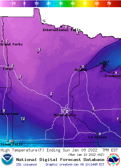
A few spots in southwestern Minnesota could reach the lower teens.
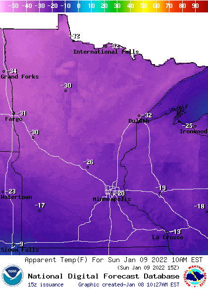
The lowest wind chill temps of the weekend will occur Sunday morning. Here are 9 a.m. Sunday forecast wind chills:
Back to forecast highs, Twin Cities metro area highs are projected to reach the single digits on Monday, followed by mid 20s Tuesday, then mid 30s Wednesday and lower 30s Thursday and Friday.
Temps will probably retreat next weekend and stay below normal into the following week. The NWS Climate Prediction Center shows a tendency for below normal temps in Minnesota and western Wisconsin from Jan. 15 through Jan. 21:
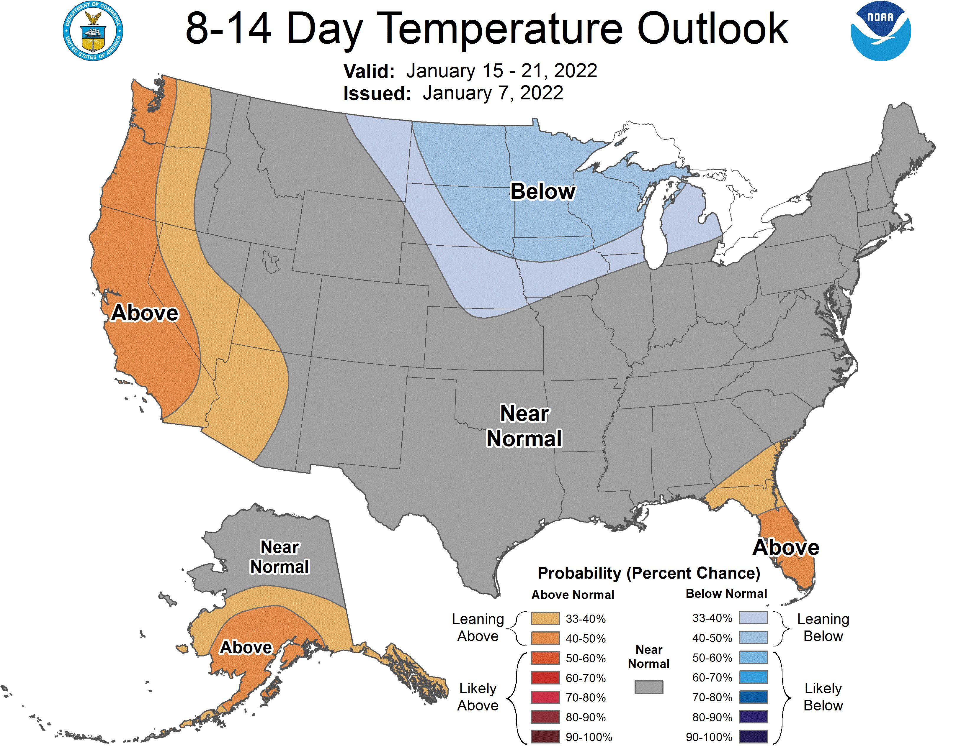
We’ll see if that changes.
How fast do temps rise?
Our average Twin Cities high temp is coldest (23 degrees) from Jan. 10 through Jan. 24. Looking ahead, our average Twin Cities high temp rises 10 degrees from Feb. 1 to Feb 28, then it rises another 15 degrees between March 1 and March 31.
Programming note
You can hear my live weather updates on MPR News at 7:35 a.m., 9:35 a.m. and 4:39 p.m. each Saturday and Sunday.

