Arctic cold lingers through Monday; nice warmup begins on Tuesday
Update on wind chill advisories

An arctic high pressure system will keep very cold air over us this Sunday and Monday.
A wind chill advisory continues until noon this Sunday in northwestern Minnesota, for wind chills as low as -40. A wind chill advisory continues until 1 p.m. this Sunday in north-central and northeastern Minnesota, for wind chills as low as -35:

From Willmar through the Twin Cities metro area and on into western Wisconsin, wind chill advisories run until 11 a.m. this Sunday, for wind chills of -25 to -30:
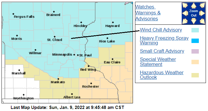
Here are details of the Twin Cities wind chill advisory:
Create a More Connected Minnesota
MPR News is your trusted resource for the news you need. With your support, MPR News brings accessible, courageous journalism and authentic conversation to everyone - free of paywalls and barriers. Your gift makes a difference.
URGENT - WINTER WEATHER MESSAGE National Weather Service Twin Cities/Chanhassen MN 404 AM CST Sun Jan 9 2022 MNZ053-060>063-067>070-075>077-WIZ014>016-023-091700- /O.CON.KMPX.WC.Y.0004.000000T0000Z-220109T1700Z/ Chisago-Hennepin-Anoka-Ramsey-Washington-Sibley-Carver-Scott- Dakota-Nicollet-Le Sueur-Rice-Polk-Barron-Rusk-St. Croix- Including the cities of Center City, Minneapolis, Blaine, St Paul, Stillwater, Gaylord, Chanhassen, Chaska, Victoria, Shakopee, Hastings, St Peter, Le Sueur, Faribault, Osceola, Rice Lake, Ladysmith, and Hudson 404 AM CST Sun Jan 9 2022 ...WIND CHILL ADVISORY REMAINS IN EFFECT UNTIL 11 AM CST THIS MORNING... * WHAT...Very cold wind chills expected. Wind chills as low as 30 below zero. * WHERE...Portions of northwest and west central Wisconsin and central, east central and south central Minnesota. * WHEN...From 3 AM to 11 AM CST Sunday. * IMPACTS...The dangerously cold wind chills could cause frostbite on exposed skin in as little as 10 minutes. PRECAUTIONARY/PREPAREDNESS ACTIONS... Use caution while traveling outside. Wear appropriate clothing, a hat, and gloves.
You can hear updated weather information for Minnesota and western Wisconsin on the Minnesota Public Radio News network, and you can see updated weather info on the MPR News live weather blog.
Temperature trends
Sunday afternoon highs will be in the single digits below zero in most of the northern half of Minnesota. Highs in the single digits above zero are expected across much of southern Minnesota and portions of western Wisconsin. A few spots in far southwestern Minnesota could reach the lower teens. For perspective, our average Twin Cities high temp is 24 degrees this time of year.
Low temperatures late Sunday night and early Monday morning will range from the 20s below zero in northern Minnesota to single digits below zero in far southern Minnesota:

Twin Cities metro area lows are expected to range from about -9 near the downtown areas to as low as -14 in the outer suburbs.
The Duluth NWS office notes that Monday morning lows in northern Minnesota are expected to be colder than the temps at the North Pole:

Monday highs will be in the negative single digits in northern Minnesota, with positive single digits to the south:

Temps rebound nicely on Tuesday, with afternoon highs in the 20s and 30s:
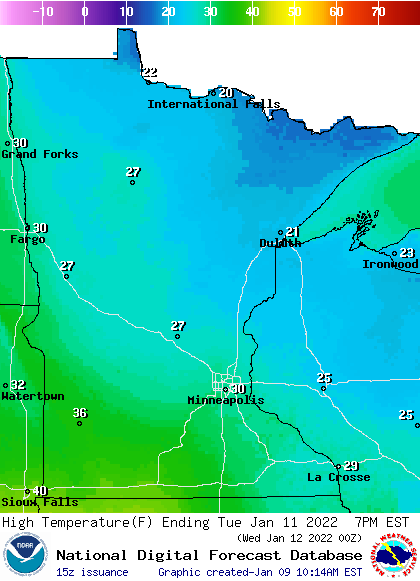
After a high of about 30 degrees on Tuesday, Twin Cities metro area highs are projected to reach the mid 30s Wednesday and Thursday, followed by lower 30s on Friday.
Snow chances?
There’s a chance of light snow showers this Sunday evening in central and southern Minnesota and west-central Wisconsin. Much of the coming week looks dry, with a chance of snow Thursday night and Friday. Check forecast updates.
Weather nugget
So far this snow season, the official Twin Cities snow total (measured at MSP airport) is 24.8 inches. That’s 2.9 inches above normal to this point in our snow season. We average 51.2 inches of snow per snow season in the Twin Cities.
Programming note
You can hear my live weather updates on MPR News at 7:35 a.m., 9:35 a.m. and 4:39 p.m. each Saturday and Sunday.