
A bit cooler Sunday; passing flurry possible
Light winds today
Go Deeper.
Create an account or log in to save stories.
Like this?
Thanks for liking this story! We have added it to a list of your favorite stories.


Our Sunday will feature temps that are slightly below average, plus reasonable winds. Some people in Minnesota and western Wisconsin could see a passing flurry.
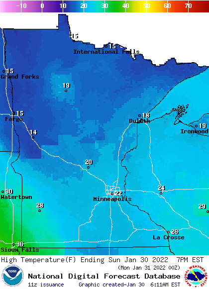
Sunday temps and winds
Our average Twin Cities high temp is 24 degrees this time of year. We’ll top out somewhere in the lower 20s this Sunday. Most of southern Minnesota and western Wisconsin will have Sunday highs in the 20s, with teens in much of northern Minnesota:
Wind gusts will be under 10 mph in many locations Sunday afternoon:
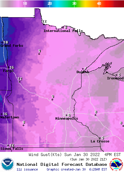
Some spots in far northwestern Minnesota will have gusts of 14-18 mph. Forecast wind gusts are in knots, with 12 knots equal to 13.8 mph.
Turn Up Your Support
MPR News helps you turn down the noise and build shared understanding. Turn up your support for this public resource and keep trusted journalism accessible to all.
You can hear updated weather information for Minnesota and western Wisconsin on the Minnesota Public Radio News network, and you can see updated weather info on the MPR News live weather blog.
Snow cover looks good
There’s ample snow cover for cross-country skiing, snowboarding and sledding across most of Minnesota right now. Here’s the Thursday snow depth map, which should still be accurate for most locations:

The Minneapolis-St. Paul International Airport snow depth was 7 inches Saturday morning. Most of the northern half of Minnesota has one foot or more of snow cover. Parts of northeastern Minnesota have at least 2 feet of snow on the ground.
This Updraft blog will be updated by around 10:15 a.m. with some snow totals from the weekend blizzard in New England, plus a look at our week ahead.
Programming note
You can hear my live weather updates on MPR News at 7:35 a.m., 9:35 a.m. and 4:39 p.m. each Saturday and Sunday.

