
A cold Sunday, with light snow by late afternoon/evening
Updated snow amounts
Go Deeper.
Create an account or log in to save stories.
Like this?
Thanks for liking this story! We have added it to a list of your favorite stories.


Sunday morning lows ranged from single digits below zero in southern Minnesota to 20s and 30s below zero in the north. There was also a low of -42 in International Falls this morning, tying their Feb. 13 record low temp that was set last year.
Wind chill advisories continue until 9 a.m. for parts of central Minnesota and most of northern Minnesota:
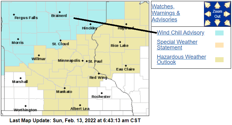
The wind chill advisory in northwestern Minnesota runs until noon today.
You can hear updated weather information for Minnesota and western Wisconsin on the Minnesota Public Radio News network, and you can see updated weather info on the MPR News live weather blog.
Turn Up Your Support
MPR News helps you turn down the noise and build shared understanding. Turn up your support for this public resource and keep trusted journalism accessible to all.
Cold highs
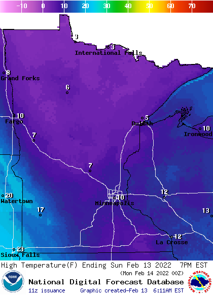
Sunday high temperatures reach the teens in parts of southern Minnesota, with single digit highs in central and northern Minnesota:
Snow outlook
Snow will begin in northwestern Minnesota early Sunday afternoon, then spread southeastward into central and eastern Minnesota and western Wisconsin by evening.
The National Oceanic and Atmospheric Administration’s North American Mesoscale (NAM) forecast model shows the potential precipitation pattern from noon Sunday to 6 a.m. Monday:
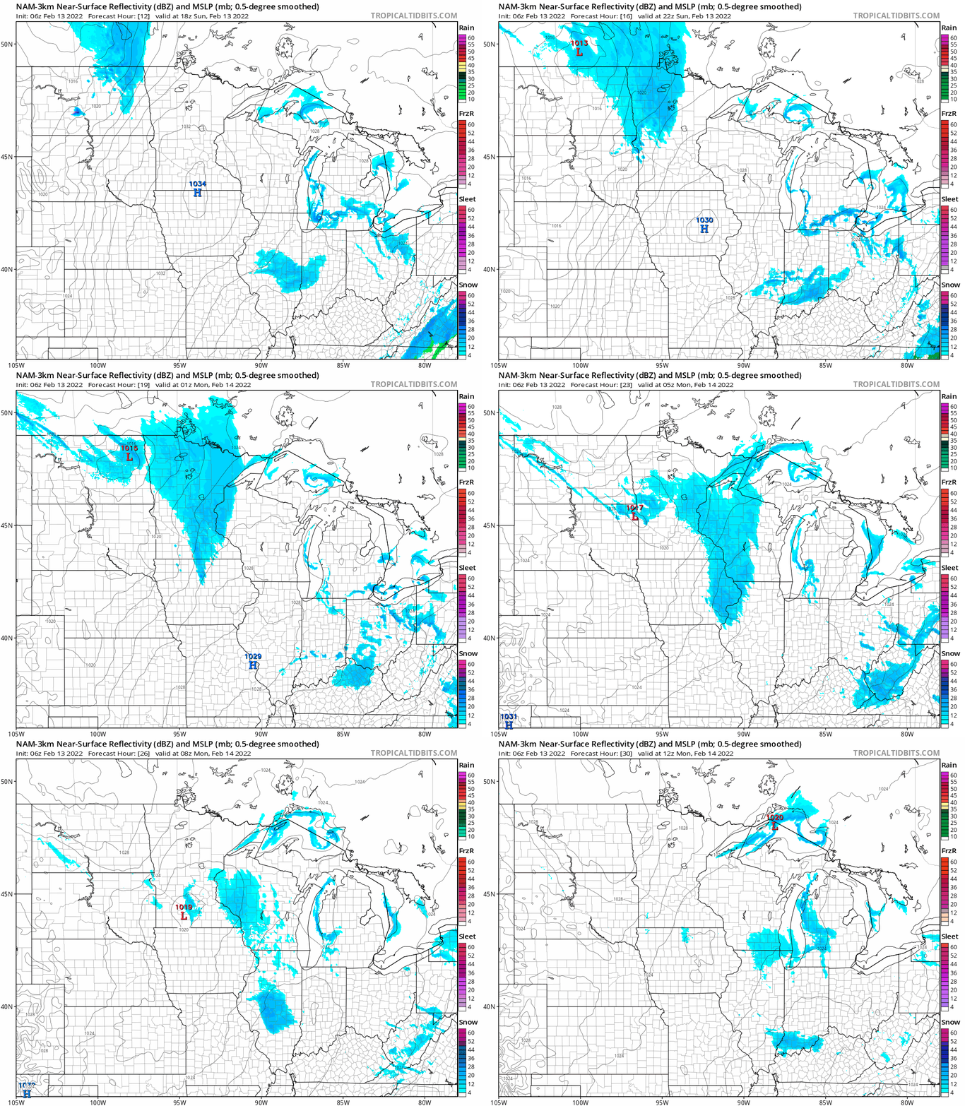
The snow could arrive in the Twin Cities metro area around 5 or 6 p.m. on Sunday and continue into the evening, with an inch or two of accumulation.
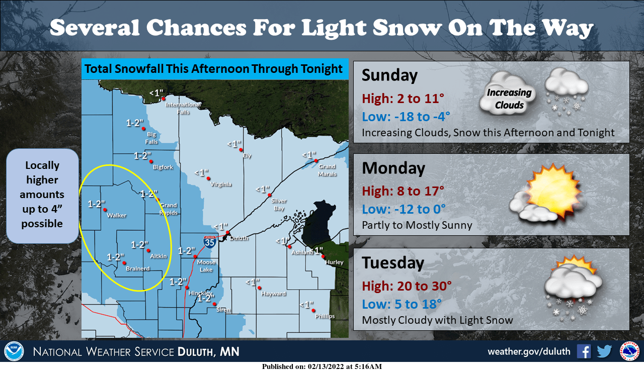
Here are the potential snow amounts through Sunday night:
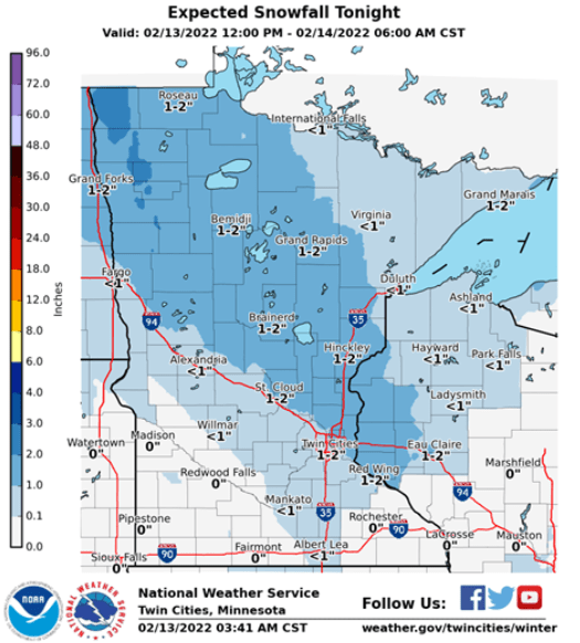
Parts of northern Minnesota could see a bit more than 2 inches:
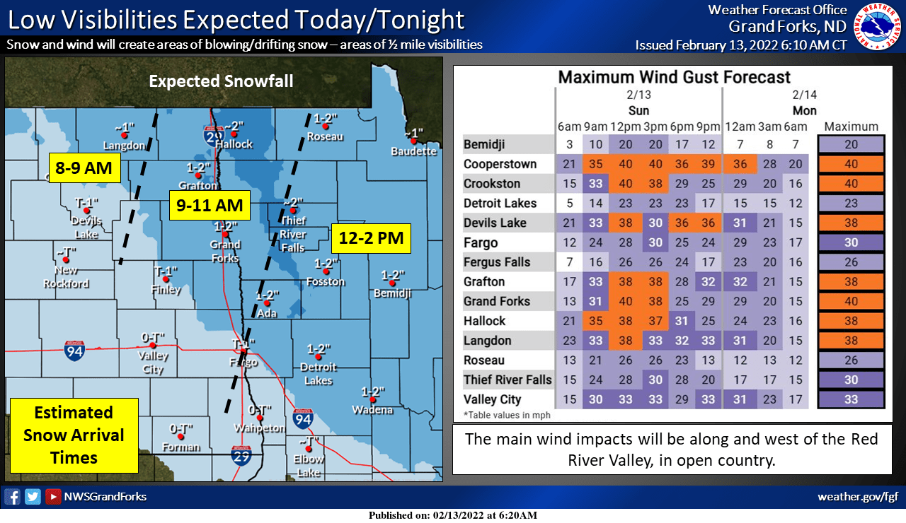
Snow and blowing snow in northwestern Minnesota Sunday and Sunday night
Here are snow arrival times and expected wind gusts in eastern North Dakota and northwestern Minnesota:
Winter weather advisories (darker blue) have been issued for northeastern North Dakota and portions of northwestern Minnesota:
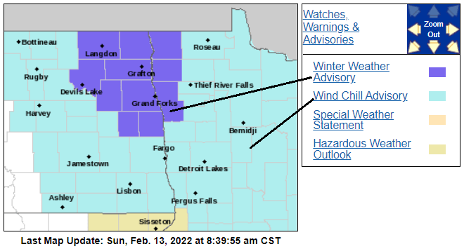
Here are details of the winter weather advisory:
URGENT - WINTER WEATHER MESSAGE National Weather Service Grand Forks ND 258 AM CST Sun Feb 13 2022 MNZ001-004-007-NDZ007-008-015-016-026-027-029-030-054-140600- /O.NEW.KFGF.WW.Y.0018.220213T1600Z-220214T0600Z/ /O.CON.KFGF.WC.Y.0015.000000T0000Z-220213T1800Z/ West Polk-Kittson-West Marshall-Cavalier-Pembina-Ramsey- Eastern Walsh-Nelson-Grand Forks-Steele-Traill-Western Walsh- Including the cities of Crookston, East Grand Forks, Hallock, Karlstad, Lancaster, Warren, Stephen, Argyle, Langdon, Cavalier, Walhalla, Drayton, Pembina, Neche, St. Thomas, Devils Lake, Grafton, Park River, Lakota, Mcville, Aneta, Tolna, Grand Forks, Finley, Hope, Mayville, Hillsboro, Hatton, Portland, Edinburg, Adams, and Lankin 258 AM CST Sun Feb 13 2022 ...WIND CHILL ADVISORY REMAINS IN EFFECT UNTIL NOON CST TODAY... ...WINTER WEATHER ADVISORY IN EFFECT FROM 10 AM THIS MORNING TO MIDNIGHT CST TONIGHT... * WHAT...For the Winter Weather Advisory, snow expected. Total snow accumulations of 1 to 3 inches. South winds will gust up to 35 mph from late morning through the afternoon. There may be an hour or two of a lull in the late afternoon, before winds turn northwest and gust up to 35 mph again. Falling and blowing snow will result in visibilities below a half mile in open country. For the Wind Chill Advisory, very cold wind chills, as low as 40 below zero. * WHERE...Portions of the central and northern Red River Valley. * WHEN...For the Winter Weather Advisory, from 10 AM this morning to midnight CST tonight. For the Wind Chill Advisory, until noon CST today. * IMPACTS...Plan on slippery road conditions. Areas of falling and blowing snow will significantly reduce the visibility. The dangerously cold wind chills could cause frostbite on exposed skin in as little as 10 minutes. PRECAUTIONARY/PREPAREDNESS ACTIONS... Slow down and use caution while traveling. Use caution while outside. Wear appropriate winter clothing. The latest road conditions for North Dakota can be found at dot.nd.gov/travel and for Minnesota at 511mn.org, or by calling 5 1 1 in either state.
Check forecast updates if you plan to travel in northeastern North Dakota or northwestern Minnesota today or tonight.
Programming note
You can hear my live weather updates on MPR News at 7:35 a.m., 9:35 a.m. and 4:39 p.m. each Saturday and Sunday.

