
Several cool days this week; no big storms in sight
Weekend snow map
Go Deeper.
Create an account or log in to save stories.
Like this?
Thanks for liking this story! We have added it to a list of your favorite stories.


Are you wondering how much snow you and your neighbors shoveled Sunday morning? The official snow total at Minneapolis-St. Paul International Airport overnight Saturday night was 3.3 inches, but many spots in the west and north metro reported 4 to 5 inches of snow:
Excelsior tallied 6 inches of new snow. Some spots in the southeast part of the metro area had less than 2 inches of snow Saturday night.
Many weekend snow reports are posted by the NWS here. You can zoom in for more details of the snow reports at the linked site, and you can click on or hover over any snow report to get info on the exact location and time of snow measurement.
There is a county by county weekend snow listing here.
Turn Up Your Support
MPR News helps you turn down the noise and build shared understanding. Turn up your support for this public resource and keep trusted journalism accessible to all.
Monday snow chance?
A low pressure system will spread snow across Iowa, northern Illinois and far southern Wisconsin Sunday night into Monday morning. The far southeastern corner of Minnesota could get clipped by light snow showers late Sunday night and early Monday morning.
The National Oceanic and Atmospheric Administration’s North American Mesoscale (NAM) forecast model shows the potential precipitation pattern from 8 p.m. Sunday to noon on Monday:

You can hear updated weather information for Minnesota and western Wisconsin on the Minnesota Public Radio News network, and you can see updated weather info on the MPR News live weather blog.
Temperature trends
Monday highs will be mainly in the 20s, with some lower 30s in far southeastern Minnesota:
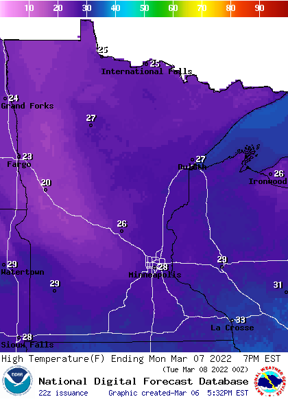
Some spots in the metro area could touch 30 degrees.
Tuesday highs will range from 20s in northwestern Minnesota to 40s in the far southeast:
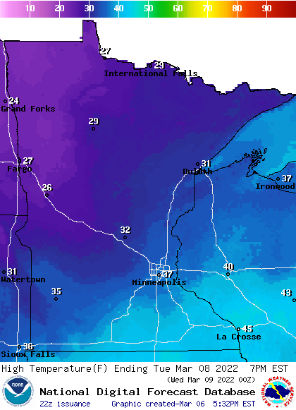
Twin Cities metro area highs will probably reach the upper 30s Tuesday afternoon. Our average high is 38 degrees on March 8.
Twin Cities metro area highs are projected to reach the mid 20s on Wednesday, followed by lower 20s Thursday and Friday. The metro area could see a few snow light snow showers late Tuesday and also on Thursday.
Weather nugget
The official Twin Cities snowfall total is now 46.8 inches for this snow season, which began last fall. That’s 5.1 inches above normal for this point in our snow season. The official snow measurements for the Twin Cities are taken at MSP airport.
Programming note
You can hear my live weather updates on MPR News at 7:35 a.m., 9:35 a.m. and 4:39 p.m. each Saturday and Sunday.

