
Chilly Saturday; snow chances favor northern Minnesota
Updated snow cover map
Go Deeper.
Create an account or log in to save stories.
Like this?
Thanks for liking this story! We have added it to a list of your favorite stories.


Overnight low temps dipped below zero across most of Minnesota, with a few spots in far southern Minnesota staying slightly above zero into Saturday morning.
Northern Minnesota is starting the day with teens below zero and a few 20s below zero. MSP airport reported an overnight low of -1 through 6 a.m., Saturday, but temps could dip slightly lower before they rebound.
Minnesota highs will be mainly in the 20s Saturday afternoon, with some 30s in southwestern Minnesota and a few teens in north-central and northeastern Minnesota:
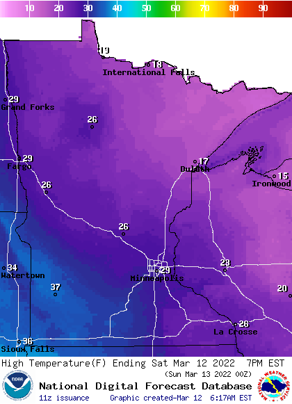
Parts of the Twin Cities metro area could touch 30.
Turn Up Your Support
MPR News helps you turn down the noise and build shared understanding. Turn up your support for this public resource and keep trusted journalism accessible to all.
Snow in the north late afternoon/evening
A low-pressure system will move across southern Canada this afternoon through Saturday night, bringing snow to portions of Minnesota.
The snow is expected to begin in northwestern Minnesota late Saturday afternoon, then spread across much of northern Minnesota and northwestern Wisconsin Saturday evening and during the overnight hours of Saturday night.
The National Oceanic and Atmospheric Administration’s North American Mesoscale (NAM) forecast model shows the potential precipitation pattern from noon Saturday to 7 a.m. on Sunday:
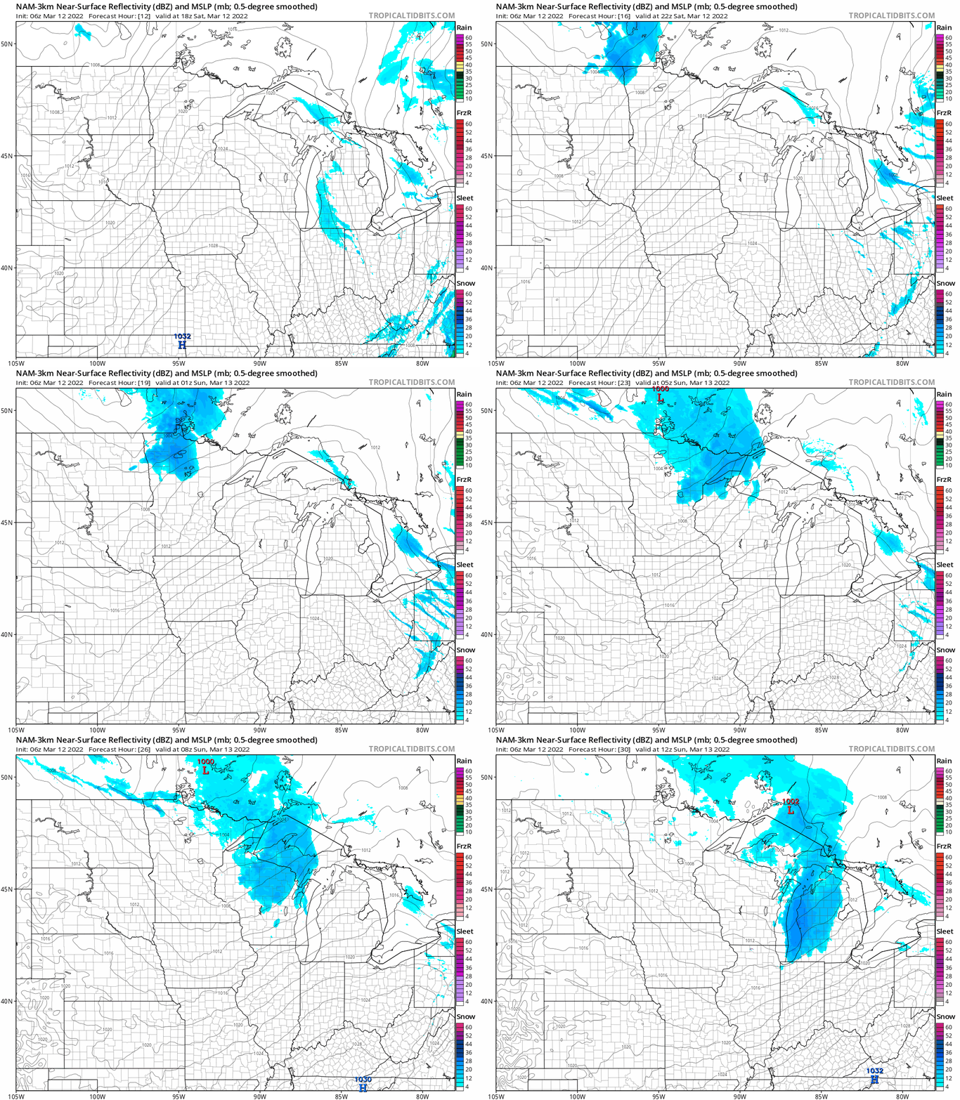
The Twin Cities metro area could get clipped by a few light snow showers or flurries late Saturday evening.
You can hear updated weather information for Minnesota and western Wisconsin on the Minnesota Public Radio News network, and you can see updated weather info on the MPR News live weather blog.
How much snow?
Northwestern Minnesota could see some 1 to 2 inch snow totals from late afternoon through Saturday evening:
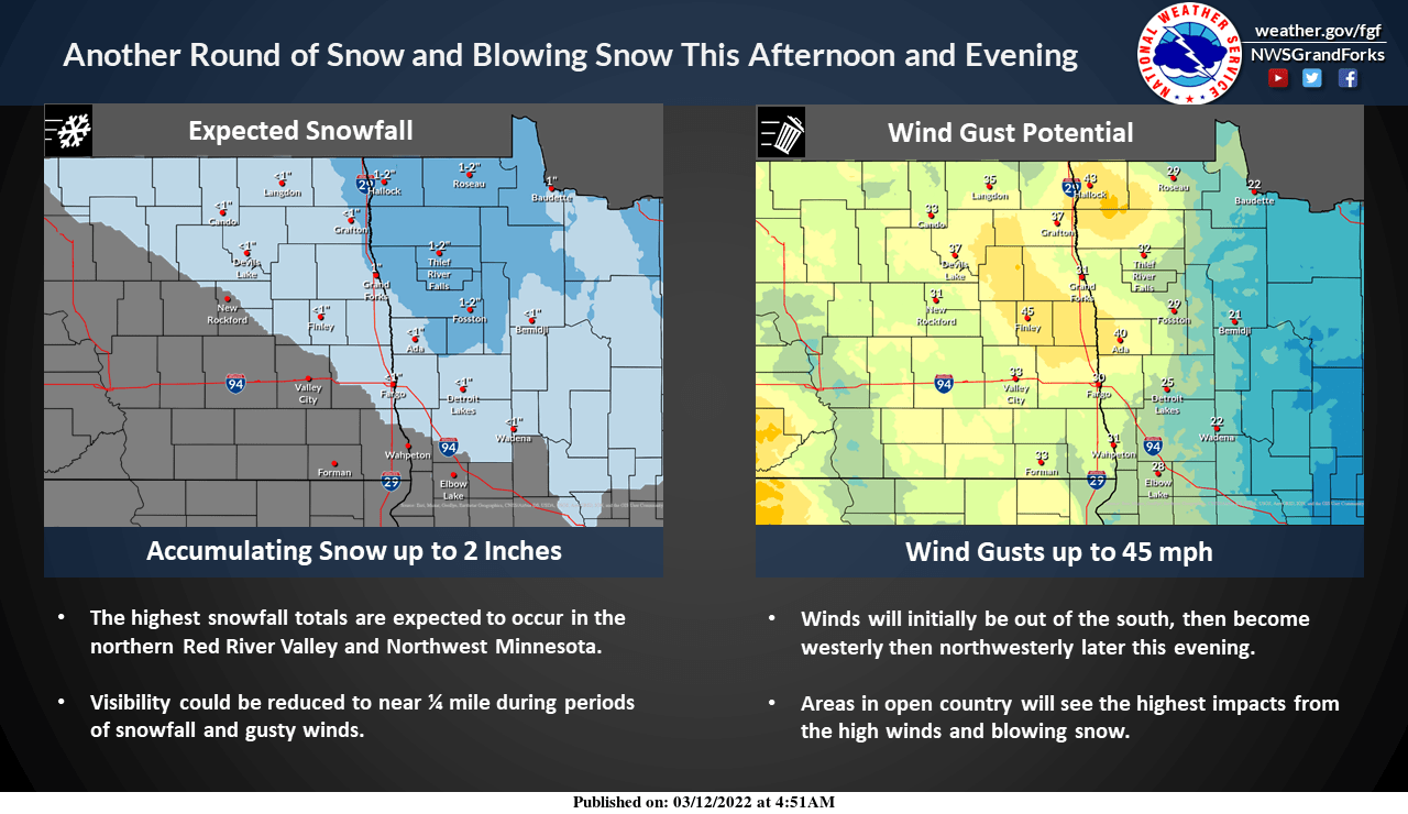
Gusty winds will reduce visibilities. A winter weather advisory covers northwestern Minnesota Saturday afternoon and evening:
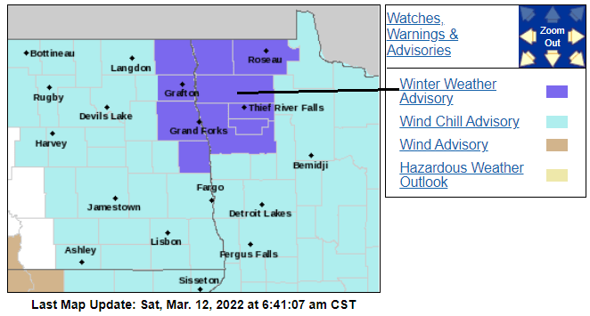
Here are details of the advisory:
URGENT - WINTER WEATHER MESSAGE National Weather Service Grand Forks ND 334 AM CST Sat Mar 12 2022 MNZ001-004-005-007-008-013>015-NDZ008-016-027-030-130600- /O.NEW.KFGF.WW.Y.0027.220312T1800Z-220313T0600Z/ /O.CON.KFGF.WC.Y.0025.000000T0000Z-220312T1600Z/ West Polk-Kittson-Roseau-West Marshall-East Marshall-Pennington- Red Lake-East Polk-Pembina-Eastern Walsh-Grand Forks-Traill- Including the cities of Crookston, East Grand Forks, Hallock, Karlstad, Lancaster, Roseau, Warroad, Greenbush, Warren, Stephen, Argyle, Newfolden, Middle River, Grygla, Thief River Falls, Red Lake Falls, Fosston, Fertile, McIntosh, Erskine, Cavalier, Walhalla, Drayton, Pembina, Neche, St. Thomas, Grafton, Park River, Grand Forks, Mayville, Hillsboro, Hatton, and Portland 334 AM CST Sat Mar 12 2022 ...WIND CHILL ADVISORY REMAINS IN EFFECT UNTIL 10 AM CST THIS MORNING... ...WINTER WEATHER ADVISORY IN EFFECT FROM NOON TODAY TO MIDNIGHT CST TONIGHT... * WHAT...For the Winter Weather Advisory, snow and blowing snow expected. Total snow accumulations of up to two inches along with visibility as low as 1/4 mile at times. Winds gusting as high as 45 mph. For the Wind Chill Advisory, very cold wind chills. Wind chills as low as 40 below zero. * WHERE...Portions of northwest Minnesota and northeast and southeast North Dakota. * WHEN...For the Winter Weather Advisory, from noon today to midnight CST tonight. For the Wind Chill Advisory, until 10 AM CST this morning. * IMPACTS...Widespread blowing snow could significantly reduce visibility. The dangerously cold wind chills could cause frostbite on exposed skin in as little as 10 minutes. PRECAUTIONARY/PREPAREDNESS ACTIONS... Slow down and use caution while traveling. Use caution while outside. Wear appropriate winter clothing. The latest road conditions for North Dakota can be found at dot.nd.gov/travel and for Minnesota at 511mn.org, or by calling 5 1 1 in either state.
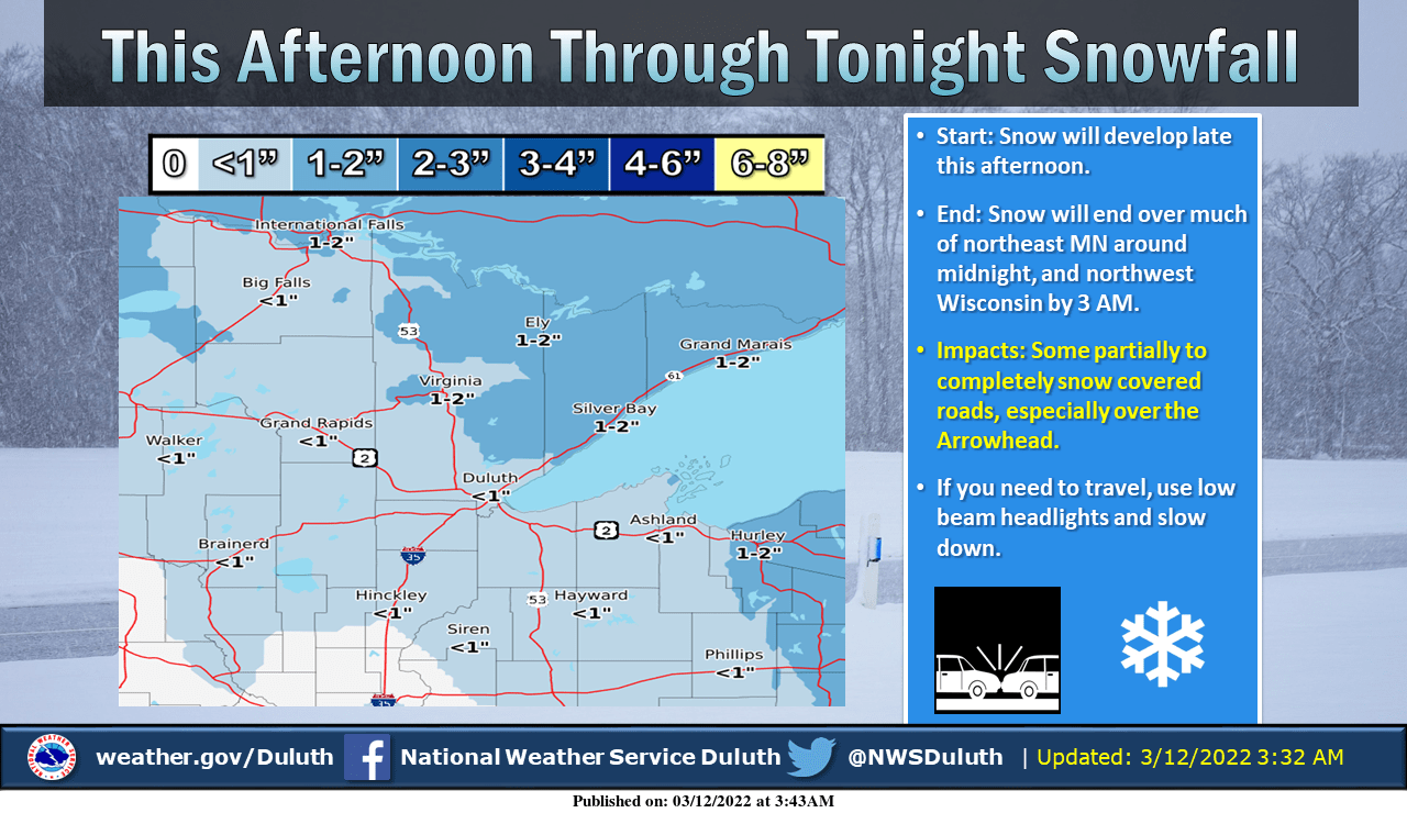
Parts of northeastern Minnesota will see 1 to 2 inches of snow late Saturday through Saturday night:
Update
This Updraft blog will be updated by 10:15 a.m. with details of a warmup on Sunday and some very warm temps this coming week.
Snow depths highest in northern Minnesota
The latest snow depth map from the Minnesota State Climatology Office shows 16 inches or more of snow cover in most of the northern half of Minnesota, with 24 inches or more of snow cover in much of north-central and northeastern Minnesota:
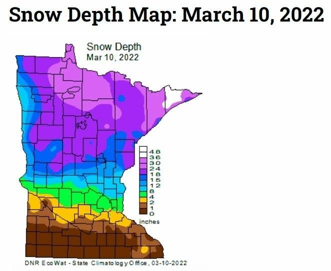
Portions of Cook County in northeastern Minnesota have more than 36 inches of snow on the ground!
Twin Cities metro area snow depths are generally in the 2 to 6-inch range, with a bit more than 6 inches in the far north metro. The Friday morning snow depth at Minneapolis-St. Paul International airport was 3 inches.
Much of far southern Minnesota has little or no snow cover right now.
Daylight saving time
Daylight saving time begins at 2 a.m. on Sunday. Our Twin Cities sunset will be at 7:17 p.m. Sunday evening.
Programming note
You can hear my live weather updates on MPR News at 7:35 a.m., 9:35 a.m. and 4:39 p.m. each Saturday and Sunday.

