
Spring arrives this weekend and temps ramp up
Updated Minnesota snow depth map

Go Deeper.
Create an account or log in to save stories.
Like this?
Thanks for liking this story! We have added it to a list of your favorite stories.


Our snow cover has been shrinking this week in many locations.

Snow lovers will be interested to know that there’s still plenty of snow on the ground in northern Minnesota and parts of central Minnesota. Here’s the weekly snow depth map from the Minnesota State Climatology Office:

Most of the northern half of Minnesota has 12 inches or more of snow on the ground and parts of northeastern Minnesota have 24 inches or more of snow cover.
Weekend temps
Our average March 19 high temp is 43 degrees in the Twin Cities. Most of the metro area will top out in the lower 50s this Saturday. Southern Minnesota will see Saturday highs in the 50s, with mainly 40s in the north:
Turn Up Your Support
MPR News helps you turn down the noise and build shared understanding. Turn up your support for this public resource and keep trusted journalism accessible to all.
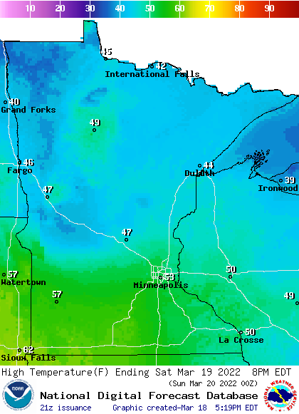
A few spots in far southwestern Minnesota could top 60 degrees Saturday afternoon.
Southwestern and south-central Minnesota will see Sunday highs in the 60s, with mainly 50s from central Minnesota into southeastern Minnesota and 40s to the north:
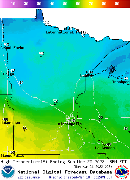
A few spots in the Twin Cities metro area could touch 60 degrees Sunday afternoon.
Dry weekend for most of Minnesota
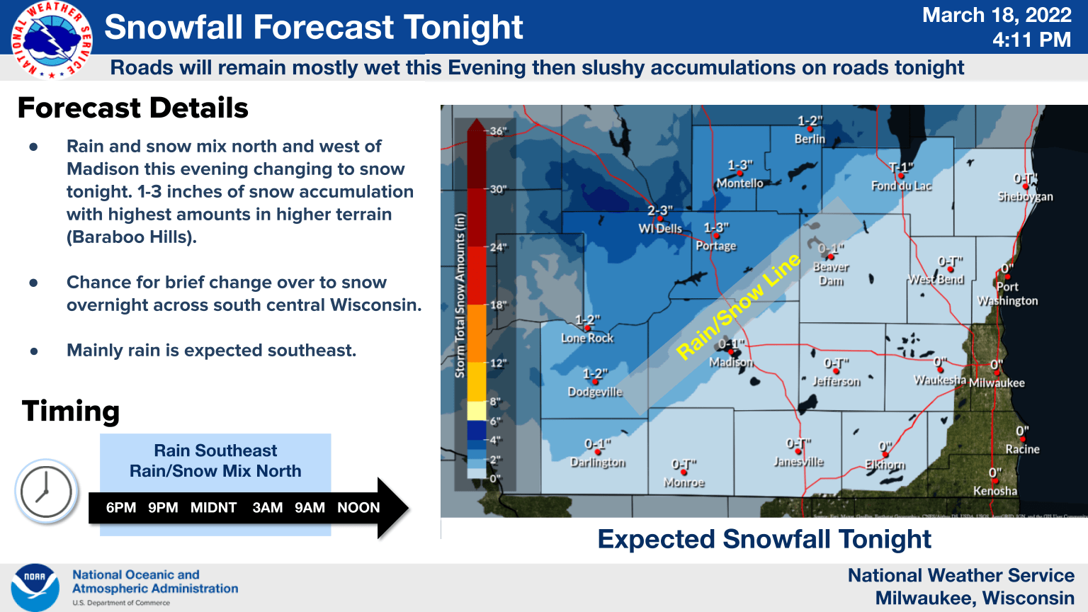
Far southeastern Minnesota could see a few rain showers or snow showers Friday evening. Accumulating snow is more likely from northeastern Iowa into central Wisconsin and parts of southern Wisconsin.
Locations near Wisconsin Dells could see 2 to 3 inches of snow Friday night into very early Saturday:
You can hear updated weather information for Minnesota and western Wisconsin on the Minnesota Public Radio News network, and you can see updated weather info on the MPR News live weather blog.
Saturday and Sunday look dry in Minnesota and far western Wisconsin. The National Oceanic and Atmospheric Administration’s North American Mesoscale (NAM) forecast model shows the potential precipitation pattern from noon Saturday to 8 p.m. on Sunday:
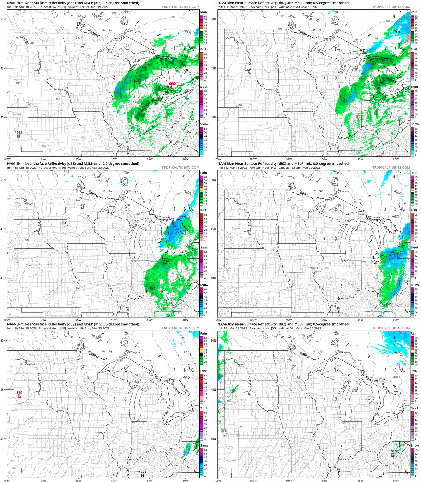
The solid black lines are isobars, which are lines of equal pressure. You’ll notice that the isobars are closer together by Sunday afternoon and evening; that’s when it’ll become a bit breezy.
Spring arrives!
Meteorological spring began on March 1, now it’s time to talk about astronomical spring, which begins on Sunday.
The vernal equinox occurs at 10:33 a.m. this Sunday, March 20. According to earthsky.org:
The March equinox – also called the vernal equinox – marks the beginning of the spring season in the Northern Hemisphere and the autumn season in the Southern Hemisphere
Day and night are not exactly the same length on the date of the equinox because we use the top of the rising or setting sun to define sunrise and sunset, rather than the center of the sun. There’s also some refraction or bending of the sun’s rays as they travel through the atmosphere, which adds to our minutes of daylight. More details on those two factors can be found here.
This coming week
Twin Cities metro area highs are projected to reach the mid 50s Monday, followed by mid 40s Tuesday and lower 40s Wednesday. Metro area highs are then expected to rebound to the lower 50s for Thursday and Friday.
The metro area will have a chance of rain showers on Monday, then periods of rain are likely Monday night and Tuesday. The rain could transition over to a rain/snow mix Tuesday night into Wednesday.
Programming note
You can hear my live weather updates on MPR News at 7:35 a.m., 9:35 a.m. and 4:39 p.m. each Saturday and Sunday.

