
Foggy start in southern Minn.; warm temps as spring begins
60s in some areas this afternoon
Go Deeper.
Create an account or log in to save stories.
Like this?
Thanks for liking this story! We have added it to a list of your favorite stories.


High pressure is parked nearby, giving us light winds as we start the day. The light winds allowed temps in some areas to drop to the dew point overnight, and areas of dense fog developed.
A dense fog advisory continues until 8 a.m. in portions of southern Minnesota:

Here are details of the dense fog advisory:
URGENT - WEATHER MESSAGE National Weather Service Twin Cities/Chanhassen MN 555 AM CDT Sun Mar 20 2022 MNZ067-075>077-083>085-092-093-201300- /O.CON.KMPX.FG.Y.0003.000000T0000Z-220320T1300Z/ Sibley-Nicollet-Le Sueur-Rice-Blue Earth-Waseca-Steele-Faribault- Freeborn- Including the cities of Gaylord, St Peter, Le Sueur, Faribault, Mankato, Waseca, Owatonna, Blue Earth, and Albert Lea 555 AM CDT Sun Mar 20 2022 ...DENSE FOG ADVISORY REMAINS IN EFFECT UNTIL 8 AM CDT THIS MORNING... * WHAT...Visibility near zero in dense fog. * WHERE...Sibley, Nicollet, Le Sueur, Rice, Blue Earth, Waseca, Steele, Faribault and Freeborn Counties. * WHEN...From now to 8 AM CDT Sunday. * IMPACTS...Hazardous driving conditions due to low visibility, and temperatures below freezing. Please drive slowly and with caution. PRECAUTIONARY/PREPAREDNESS ACTIONS... If driving, slow down, use your headlights, and leave plenty of distance ahead of you.
Patchy dense fog is also possible early this morning elsewhere in Minnesota and western Wisconsin.
Turn Up Your Support
MPR News helps you turn down the noise and build shared understanding. Turn up your support for this public resource and keep trusted journalism accessible to all.
You can hear updated weather information for Minnesota and western Wisconsin on the Minnesota Public Radio News network, and you can see updated weather info on the MPR News live weather blog.
Spring!
Meteorological spring began on March 1, now it’s time to talk about astronomical spring, which begins today.
The vernal equinox occurs at 10:33 a.m. this Sunday, March 20. According to earthsky.org:
The March equinox – also called the vernal equinox – marks the beginning of the spring season in the Northern Hemisphere and the autumn season in the Southern Hemisphere
Day and night are not exactly the same length on the date of the equinox because we use the top of the rising or setting sun to define sunrise and sunset, rather than the center of the sun. There’s also some refraction or bending of the sun’s rays as they travel through the atmosphere, which adds to our minutes of daylight. More details on those two factors can be found here.
Warmer temps
Sunday highs will reach the 60s in southwestern and south-central Minnesota, with mainly 50s elsewhere in Minnesota and western Wisconsin::
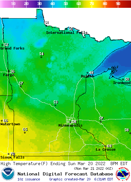
Parts of the Twin Cities metro area could touch 60 degrees. There will be some 40s in northeastern Minnesota.
Winds will start out fairly light this morning, with gusty winds developing in western Minnesota Sunday afternoon as a low pressure system approaches. Here are forecast wind gusts for 4 p.m. CDT Sunday:
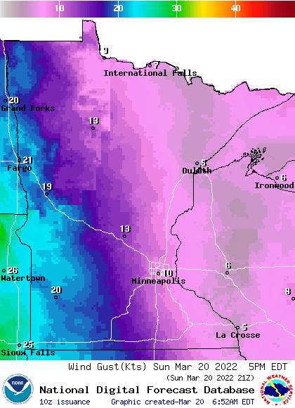
Forecast wind gusts are in knots, with 20 knots equal to 23 mph.
Update
A new Updraft blog will be posted around 10:15 today with a look at rain and snow chances over the next few days.
Programming note
You can hear my live weather updates on MPR News at 7:35 a.m., 9:35 a.m. and 4:39 p.m. each Saturday and Sunday.

