
Bright and chilly weekend; lighter winds on Sunday
Still plenty of snow cover up north

Go Deeper.
Create an account or log in to save stories.
Like this?
Thanks for liking this story! We have added it to a list of your favorite stories.


The official Twin Cities high temp was 54 degrees last Saturday, followed by 60 last Sunday. What a change in one week; we’ll have metro area highs in the 30s this weekend. Our average Twin Cities high temp is 47 degrees this time of year.
Temperature trends
Saturday highs will reach the 30s across much of southern and central Minnesota plus parts of western Wisconsin. The northern third of Minnesota will see a lot of 20s, with a few upper teens possible near the Canadian border. Wind gusts of 25 to 35 mph are expected in many areas through much of Saturday afternoon.
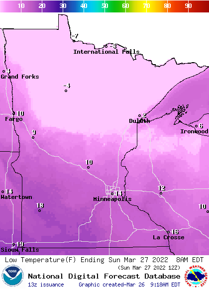
Low temps early Sunday morning will range from single digits below zero in far northern Minnesota to teens above zero in the south:
Turn Up Your Support
MPR News helps you turn down the noise and build shared understanding. Turn up your support for this public resource and keep trusted journalism accessible to all.
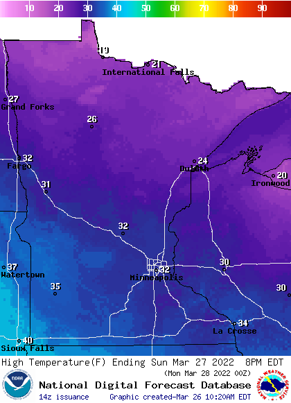
Sunday highs will be mainly in the 30s, with some 20s in northern Minnesota:
Winds will be much lighter on Sunday.
Twin Cities high temps are projected to be around 40 degrees on Monday, followed by lower 40s Tuesday, around 40 Wednesday and upper 30s Thursday and Friday.
High pressure lightens our winds on Sunday
As a high pressure system sags southward out of Canada Saturday night and Sunday, our winds will lighten up. The National Oceanic and Atmospheric Administration’s North American Mesoscale (NAM) forecast model shows the surface pressure pattern and lack of nearby precipitation from Saturday evening through Sunday afternoon:
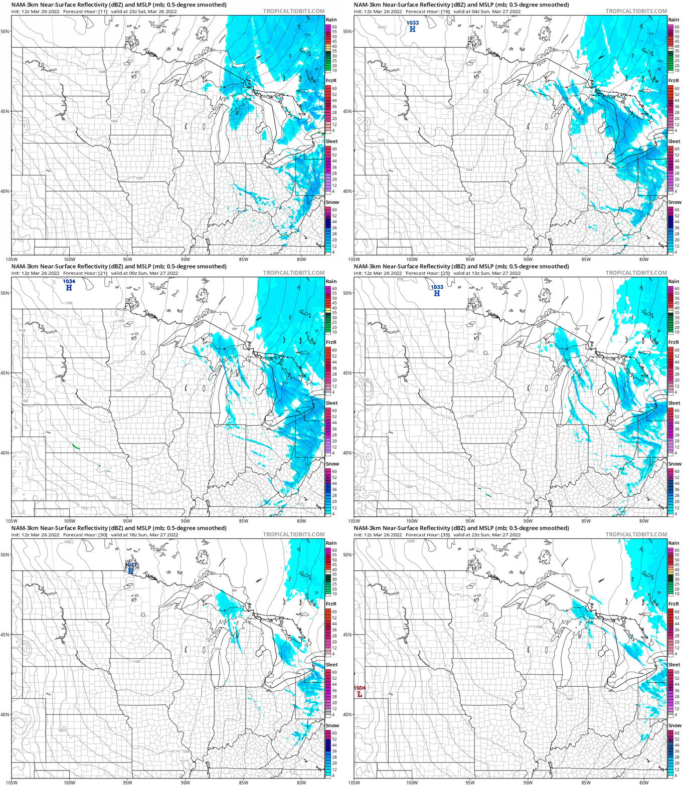
The isobars become farther apart with time, which indicates decreasing wind speeds.
Midweek wintry mess?
A low pressure system will spread precipitation across much of Minnesota and Wisconsin from Tuesday into Thursday. Changes in the temperature profile in the lowest couple miles of the atmosphere will determine how much rain, snow and sleet/freezing rain we get.
Here’s an early look at the setup this week:
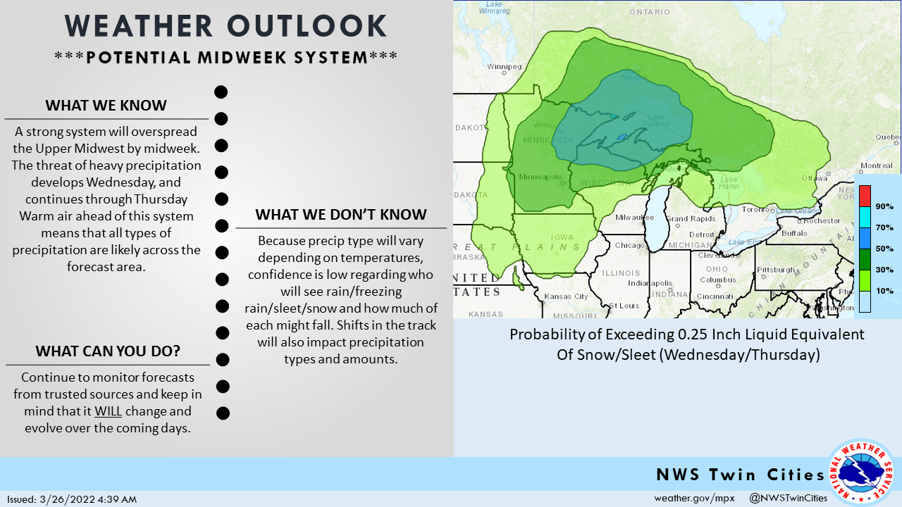
Some areas could see a plowable snow this week.
You can hear updated weather information for Minnesota and western Wisconsin on the Minnesota Public Radio News network, and you can see updated weather info on the MPR News live weather blog.
Still plenty of snow up north
Snow lovers will be interested to know that there’s still plenty of snow on the ground in much of northern Minnesota. Here’s the weekly snow depth map from the Minnesota State Climatology Office:

Most of north-central and northeastern Minnesota has 12 inches or more of snow on the ground and parts of northeastern Minnesota (especially Cook County and eastern Lake County) have 24 inches or more of snow cover.
Programming note
You can hear my live weather updates on MPR News at 7:35 a.m., 9:35 a.m. and 4:39 p.m. each Saturday and Sunday.

