
Rain and snow Sunday afternoon, mainly snow Sunday evening; wet Tuesday into Wednesday
Monday nicest day of the week

Go Deeper.
Create an account or log in to save stories.
Like this?
Thanks for liking this story! We have added it to a list of your favorite stories.


I know you don’t want to hear about snow in April, but we have to mention it.
West-central Minnesota is already seeing snow, and the snow will spread into parts of central and northern Minnesota. The transition to a rain/snow mix has begun in parts of the Twin Cities metro area and that mix will spread into west-central and northwestern Wisconsin. Most areas with the afternoon mix will see a transition to all snow Sunday evening.
A winter weather advisory includes Wilkin County of west-central Minnesota until 4 p.m. this Sunday:

Here are details of the winter weather advisory:
Turn Up Your Support
MPR News helps you turn down the noise and build shared understanding. Turn up your support for this public resource and keep trusted journalism accessible to all.
URGENT - WINTER WEATHER MESSAGE National Weather Service Grand Forks ND 110 PM CDT Sun Apr 3 2022 MNZ029-NDZ049-052-053-032100- /O.NEW.KFGF.WW.Y.0029.220403T1810Z-220403T2100Z/ Wilkin-Ransom-Sargent-Richland- Including the cities of Breckenridge, Lisbon, Enderlin, Gwinner, Milnor, Forman, Rutland, and Wahpeton 110 PM CDT Sun Apr 3 2022 ...WINTER WEATHER ADVISORY IN EFFECT UNTIL 4 PM CDT THIS AFTERNOON... * WHAT...Snow. Total snow accumulations 1 to 3 inches possible through this afternoon, with localized higher totals. * WHERE...In Minnesota, Wilkin County. In North Dakota, Ransom, Sargent and Richland Counties. * WHEN...Until 4 PM CDT this afternoon. * IMPACTS...Plan on slippery road conditions. * ADDITIONAL DETAILS...Brief bursts of heavier snow are possible, and where this occurs visibilities will be reduced to one quarter mile or less. PRECAUTIONARY/PREPAREDNESS ACTIONS... Slow down and use caution while traveling. The latest road conditions for North Dakota can be found at dot.nd.gov/travel and for Minnesota at 511mn.org, or by calling 5 1 1 in either state.
Updated Minnesota road conditions can be found here. Wisconsin road conditions can be found here.
____________________________________________________________________________________________
3 p.m. Update
The NWS has issued this statement regarding reduced visibilities in west-central and central Minnesota into Sunday evening, due to snow:
Special Weather Statement National Weather Service Twin Cities/Chanhassen MN 256 PM CDT Sun Apr 3 2022 MNZ041-042-047>051-055-057>059-040100- Douglas-Todd-Stevens-Pope-Stearns-Benton-Sherburne-Swift- Kandiyohi-Meeker-Wright- Including the cities of Alexandria, Long Prairie, Morris, Glenwood, St Cloud, Sauk Rapids, Elk River, Benson, Willmar, Litchfield, and Monticello 256 PM CDT Sun Apr 3 2022 ...Periods of heavy snow with reduced visibility this evening... An area of heavier snow with visibility less than a half mile at times will track along the I-94 corridor. Total snow accumulations will generally be less than an inch, but the reduced visibility could impact travel. Please drive slowly and with caution.
_______________________________________________________________________________________________
Snow amounts
Sunday afternoon through Sunday evening snow amounts are expected to be in the 1 to 2 inch range for much of west central Minnesota through portions of east-central Minnesota and parts of west-central Wisconsin. The metro area may see 1 to 2 inches by late Sunday evening, especially on grassy areas. Mild temps Monday afternoon should melt most of that new snow.
You can hear updated weather information for Minnesota and western Wisconsin on the Minnesota Public Radio News network, and you can see updated weather info on the MPR News live weather blog.
Wet Tuesday into Thursday
A slow-moving low pressure system will bring periods of rain to Minnesota and western Wisconsin Tuesday and Tuesday night, with snow west and rain to the east on Wednesday. Many areas with Wednesday rain are expected to see a changeover to a rain/snow mix or mainly snow from Wednesday night into Thursday.
The National Oceanic and Atmospheric Administration’s Global Forecast System (GFS) model shows the potential precipitation pattern from 7 a.m. Tuesday to 7 p.m. Thursday:
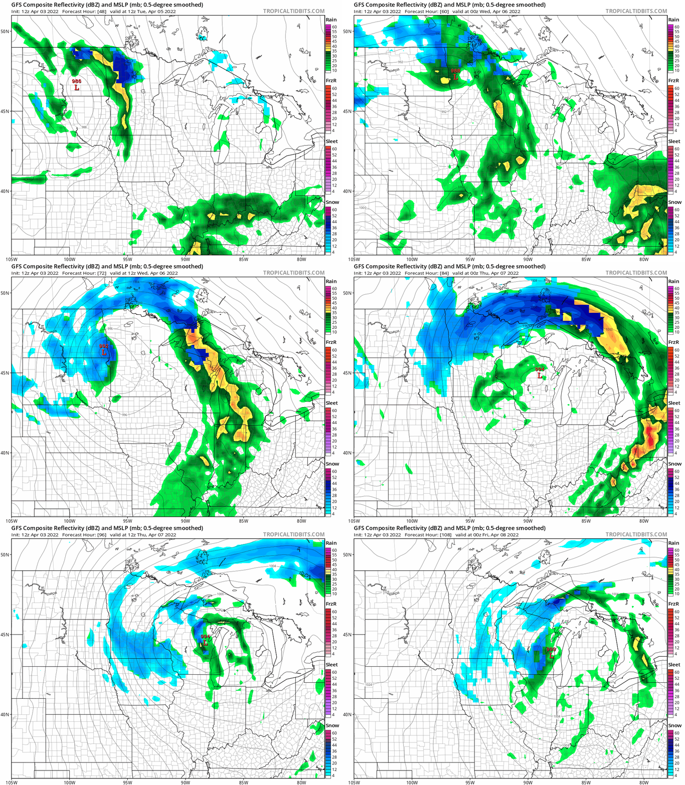
There could even be a few thunderstorms Tuesday afternoon/evening. Check forecast updates.
Temperature trends
Monday highs will be mainly in the upper 40s to around 50:
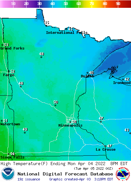
There will be some upper 30s and lower 40s in northeastern Minnesota and a few lower 50s in far southwestern Minnesota and along the Red River Valley in the northwest. We’ll top out around 50 degrees Monday afternoon in the Twin Cities.
Monday wind gusts will be light in most areas, but gusts of 15 to 20 mph are possible Monday afternoon in the Red River Valley:
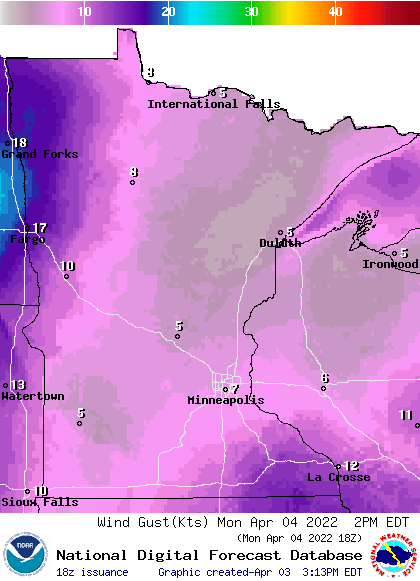
Forecast gusts are in knots, with 17 knots equal to 19.6 mph.
Back to temperatures, Twin Cities metro area highs are projected to be around 50 Tuesday and Wednesday, followed by lower 40s Thursday and then upper 40s on Friday.
Programming note
You can hear my live weather updates on MPR News at 7:35 a.m., 9:35 a.m. and 4:39 p.m. each Saturday and Sunday.

