
Sunday evening snow update; periods of rain Tuesday and Wednesday, then some flakes
Severe Weather Awareness Week
Go Deeper.
Create an account or log in to save stories.
Like this?
Thanks for liking this story! We have added it to a list of your favorite stories.


It’s that time of year. Just when it feels like spring, we get another batch of snow.
For those of you that wake up Monday morning to the sight of fresh snow on your lawn, you might be happy to know that the new snow is likely to melt on Monday.
Periods of snow or a rain/snow mix are expected Sunday evening from west-central Minnesota through east-central Minnesota, the Twin Cities metro area and parts of west-central Wisconsin. Portions of northeastern Minnesota, northwestern Wisconsin and southern Minnesota could also see some snow or a rain/snow mix at times through Sunday night.
Generally 1 to 2 inches of snow are possible in the main snow band, with the highest accumulations on grassy areas. Slushy snow accumulations are possible on roads and highways, and visibilities will be reduced Sunday evening during the heaviest snow.
Turn Up Your Support
MPR News helps you turn down the noise and build shared understanding. Turn up your support for this public resource and keep trusted journalism accessible to all.
Based on computer models, some spots in the northern portion of the Twin Cities metro area could see close to 2 inches of snow accumulation on grassy areas by 1 a.m. Monday, with 1 inch or less in much of the south metro. Some of the snow will melt before weather observers get out to measure it Monday morning.
You can hear updated weather information for Minnesota and western Wisconsin on the Minnesota Public Radio News network, and you can see updated weather info on the MPR News live weather blog.
Updated Minnesota road conditions can be found here. Wisconsin road conditions can be found here.
Temperature trends
Monday highs will be mainly in the upper 40s to around 50:
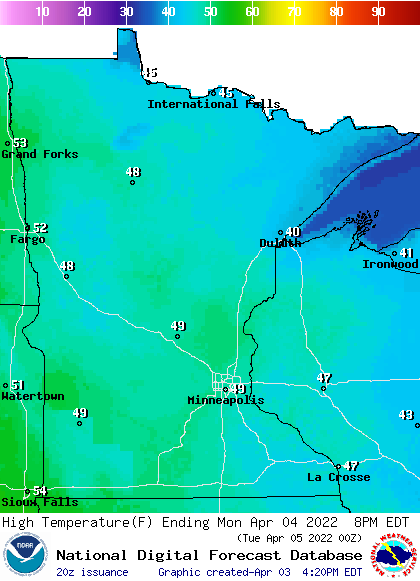
There will be some upper 30s and lower 40s in northeastern Minnesota and a few lower 50s in far southwestern Minnesota and along the Red River Valley in the northwest. We’ll top out around 50 degrees Monday afternoon in the Twin Cities.
Monday afternoon wind gusts will be fairly light in most areas, but gusts of 15 to 20 mph are possible in the Red River Valley:

Forecast gusts are in knots, with 17 knots equal to 19.6 mph.
Back to temperatures, Twin Cities metro area highs are projected to be around 50 Tuesday and Wednesday, followed by lower 40s Thursday and then upper 40s on Friday.
We could return to highs in the 50s next Saturday, with 60s on Sunday.
Wet Tuesday into Thursday
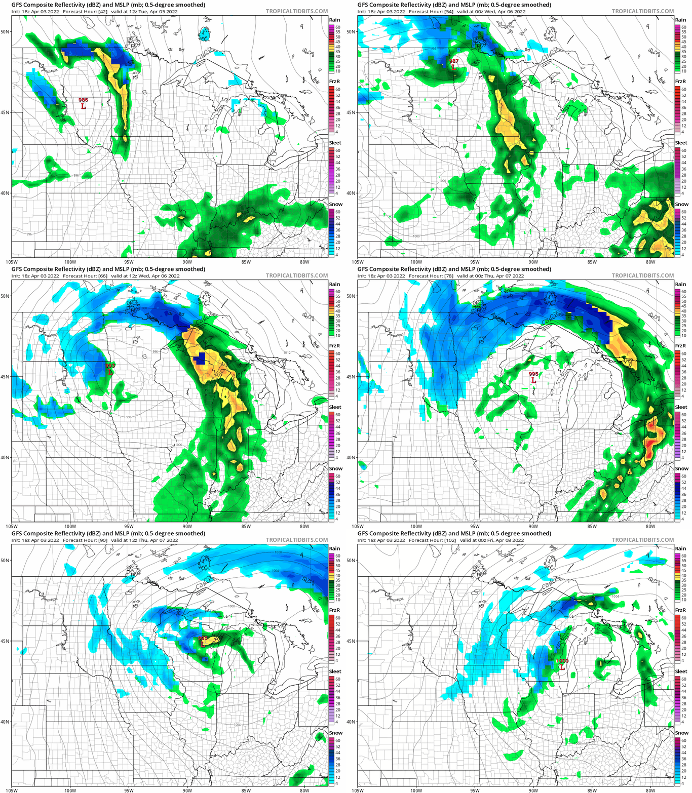
A slow-moving low pressure system will bring periods of rain to Minnesota and western Wisconsin Tuesday and Tuesday night, with snow to the west and rain to the east on Wednesday. Many areas that see rain on Wednesday are expected to see a changeover to a rain/snow mix or mainly snow from Wednesday night into Thursday.
The National Oceanic and Atmospheric Administration’s Global Forecast System (GFS) model shows the potential precipitation pattern from 7 a.m. Tuesday to 7 p.m. Thursday:
Severe weather awareness week
According to the National Weather Service:
April 4th through the 8th is Severe Weather Awareness Week in Minnesota. More information on Severe Weather Awareness Week activities in Minnesota can be obtained from the Minnesota Division of Homeland Security and Emergency Management.
April 4th through the 8th is also Tornado and Severe Weather Awareness Week in the state of Wisconsin. More information can be obtained from Wisconsin Emergency Management.
The National Weather Service will focus on different severe weather topics each day this week:
Monday, April 4th - Weather Alerts and Warnings
Tuesday, April 5th - Severe Storms, Lightning, and Hail
Wednesday, April 6th - Floods
Thursday, April 7th - Tornadoes
Friday, April 8th - Extreme Heat
Here’s info that the NWS posted regarding Monday’s topic, Weather Alerts and Warnings:
Watches...
Are issued when conditions are favorable for tornadoes, severe thunderstorms or flash floods. If you are in a watch area, continue with normal activities but also make plans to seek shelter if necessary.Warnings...
Are issued when severe weather has been reported or is imminent. Seek shelter immediately if you are in or near the path of the storm. Warnings are issued by county and city names. Make sure you know the name of the county in which you live and the cities that surround you.Advance Information...
The forecast and warning process begins one or more days ahead of time, when the threat area is determined. Hazardous weather outlooks are issued early every morning, and updated as conditions warrant.If a Watch is Issued...
Local weather offices are staffed with extra personnel. State officials are notified and they pass the information to the county and local level. Counties and cities activate their spotter groups as the threat increases. TV and radio stations pass the word to the public.If a Warning is Issued...
Warnings are disseminated swiftly in a multitude of ways, including TV, radio, and over the internet. Advances in technology have allowed people to receive warnings via cell phone, pager, and numerous other methods. Spotters provide important reports on the storm, and emergency officials carry out the plans that the emergency managers have developed. Updates are issued frequently until the immediate threat has ended.Sirens...
Counties and cities own the sirens and therefore decide how and when to activate them. The National Weather Service does not sound them. There are many different policies by counties and cities. Some will activate them across the entire county for a tornado warning only. Others will activate sirens countywide for tornado warnings and all severe thunderstorm warnings. Some will activate sirens across the entire county for tornado warnings and severe thunderstorms that have winds of at least 70 or 75 mph. Others will activate sirens only for portions of counties. Also, local officials may sound the sirens anytime they believe severe weather is a threat, even if there is no warning from the National Weather Service.Sirens normally sound about 3 minutes and then go silent. It is very rare to keep the sirens sounding for the entire warning, since that will cause the backup battery to run out, which would be critical in the event power goes out. Furthermore, the siren motor will fail much more quickly if the siren sounds continuously. Some jurisdictions may repeat siren activation every few minutes. There is no such thing as an "All Clear" for storms.
Media...
Media outlets receive the warning information and disseminate it to you, often by interrupting programming. Many television stations use a crawl and other visual means.NOAA Weather Radio...
The tone alert feature of NOAA Weather Radio will activate specially built receivers, sounding an alarm to alert you to the danger. It sounds its alert anytime the National Weather Service issues a warning, even in the middle of the night. Make sure you have a NOAA Weather Radio, as you can not always depend on sirens, phone calls or seeing the warnings on television.
Programming note
You can hear my live weather updates on MPR News at 7:35 a.m., 9:35 a.m. and 4:39 p.m. each Saturday and Sunday.

