
Weekend weather: Milder temps; brightest day will be Saturday
Sunday rain chance highest in western Minnesota
Go Deeper.
Create an account or log in to save stories.
Like this?
Thanks for liking this story! We have added it to a list of your favorite stories.


I’ll get to the weekend forecast shortly, but I’ll first give you an update on our Thursday weather.
Don’t be alarmed if you hear sirens Thursday at 1:45 p.m. and 6:45 p.m.:
This is Severe Weather Awareness Week in Minnesota and Wisconsin. Here are details of the warning drills and siren activations:
Tornado Watch/Warning Drills
The National Weather Service, Wisconsin Emergency Management, the Minnesota Division of Homeland Security and Emergency Management, and other state, county and local agencies have come together to host Severe Weather Awareness Week activities. Thursday, April 7th is the day for tornado drills and working on your safety plans. The schedule for April 7th is as follows:
(all times CDT)
1:45 PM: Most counties in Wisconsin and Minnesota will activate outdoor warning siren systems and other notification systems. The choice to activate sirens is a decision made by the counties and cities. The NWS and others will also post on social media. NOAA Weather Radio will also activate with the Routine Weekly Test code.
6:45 PM: Many counties in Wisconsin and Minnesota will activate outdoor warning siren systems and other notification systems. The choice to activate sirens is a decision made by the counties and cities. The NWS and others will also post on social media. NOAA Weather Radio will also activate with the Routine Weekly Test code.
______________________________________________________
Siren Activation Information
Counties and cities own the sirens, and therefore decide how and when to activate them. The National Weather Service does not sound them.
There are many different policies regarding siren activation that are used by the various cities and counties. Some will activate sirens across the entire county for tornado warnings only. Others will activate sirens countywide for tornado warnings and all severe thunderstorm warnings. Some will activate sirens across the entire county for tornado warnings and severe thunderstorms that have winds of at least 70 or 80 mph. Others will activate sirens only for portions of counties. Local officials may also sound the sirens anytime they believe severe weather is a threat, even if there is no warning from the National Weather Service.
Sirens normally sound for about three minutes, and then go silent. It is very rare to keep the sirens sounding for the entire warning, since that would cause the backup battery to run out, which would be critical in the event that power goes out. Furthermore, the siren motor will fail much more quickly if the siren sounds continuously. Some jurisdictions may repeat siren activation every few minutes.
There is no such thing as an "all-clear" for storms.
Please check with your local public safety officials for details on when warning sirens are sounded in your community.
Snow, rain, strong winds in some areas Thursday afternoon
A strong low-pressure system centered over north-central Wisconsin will continue to bring periods of snow to much of Minnesota and northern Wisconsin Thursday afternoon.
Turn Up Your Support
MPR News helps you turn down the noise and build shared understanding. Turn up your support for this public resource and keep trusted journalism accessible to all.
There will be a mix of rain and snow at times, especially from the Twin Cities metro area into southeastern Minnesota and southern Wisconsin.
A winter weather advisory continues until 7 p.m. in northeastern Minnesota, with a winter storm warning until 7 a.m. Friday in parts of northwestern Wisconsin:

Here are details of the winter weather advisory:
URGENT - WINTER WEATHER MESSAGE National Weather Service Duluth MN 752 AM CDT Thu Apr 7 2022 MNZ037-080000- /O.CON.KDLH.WW.Y.0016.000000T0000Z-220408T0000Z/ Carlton and South St. Louis- Including the city of Duluth 752 AM CDT Thu Apr 7 2022 ...WINTER WEATHER ADVISORY REMAINS IN EFFECT UNTIL 7 PM CDT THIS EVENING... * WHAT...Mixed precipitation. Additional snow accumulations of up to two inches and ice accumulations of a light glaze. * WHERE...Carlton and South St. Louis County. This includes the Tribal Lands of the Fond du Lac Band. * WHEN...Until 7 PM CDT this evening. * IMPACTS...Plan on slippery road conditions. The hazardous conditions could impact the evening commute. PRECAUTIONARY/PREPAREDNESS ACTIONS... Slow down and use caution while traveling. The latest road conditions can be obtained by calling 5 1 1. Road conditions can also be found at 511mn.org for Minnesota or 511wi.gov for Wisconsin.
And here are details of the winter storm warning in portions of northwestern Wisconsin:
URGENT - WINTER WEATHER MESSAGE National Weather Service Duluth MN 752 AM CDT Thu Apr 7 2022 WIZ001-002-080100- /O.CON.KDLH.WS.W.0008.000000T0000Z-220408T1200Z/ Douglas-Bayfield- Including the cities of Superior, Washburn, and Bayfield 752 AM CDT Thu Apr 7 2022 ...WINTER STORM WARNING REMAINS IN EFFECT UNTIL 7 AM CDT FRIDAY... * WHAT...Heavy mixed precipitation. Additional snow accumulations of 1 to 6 inches and ice accumulations of a light glaze. * WHERE...Douglas and Bayfield Counties. This includes the Tribal Lands of the Red Cliff Band. * WHEN...Until 7 AM CDT Friday. * IMPACTS...Travel could be very difficult. The hazardous conditions could impact the morning or evening commute. PRECAUTIONARY/PREPAREDNESS ACTIONS... If you must travel, keep an extra flashlight, food, and water in your vehicle in case of an emergency. The latest road conditions can be obtained by calling 5 1 1. Road conditions can also be found at 511mn.org for Minnesota or 511wi.gov for Wisconsin.
There’s a wind advisory until 7 p.m. for several northwestern Minnesota counties along the Red River and also in much of west-central and southwestern Minnesota, where gusts to 55 mph are possible:

Big Stone and Traverse counties in west-central Minnesota are in a high-wind warning until 7 p.m., with gusts to 60 mph possible.
Portions of southwestern Minnesota (shaded blue) are in a winter weather advisory until 10 p.m. for 1 to 4 inches of snow plus wind gusts as high as 55 mph.
Bands of snow will cause periods of low visibilities in many areas Thursday afternoon.
You can hear updated weather information for Minnesota and western Wisconsin on the Minnesota Public Radio News network, and you can see updated weather info on the MPR News live weather blog.
Weekend temps and winds
Our temps have been very chilly the past few days, but milder temps are on tap for the weekend.
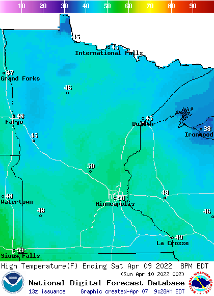
Saturday highs will be mainly in the 40s, but some spots in central Minnesota and the Twin Cities could top 50:
Saturday afternoon wind gusts will be in the 10 to 14 mph range in many areas:
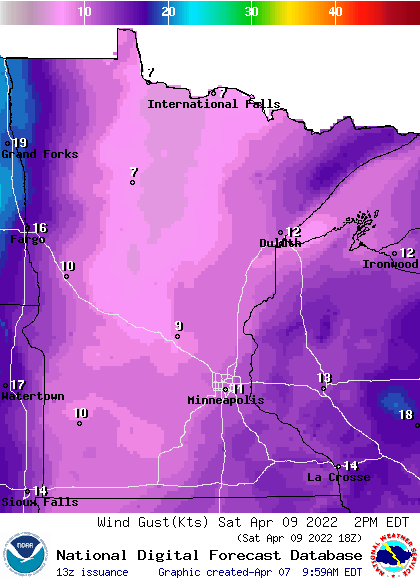
A few gusts around 20 mph are possible in and near the Red River Valley in northwestern Minnesota. Forecast wind gusts are in knots, with 11 knots equal to 12.7 mph.
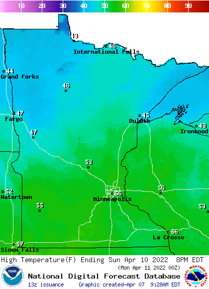
Back to temperatures, Sunday highs will reach the 50s from central and southern Minnesota into western Wisconsin, with some 40s in northern Minnesota:
Best Sunday rain chance in western Minnesota
Saturday looks dry and bright. Rain showers are expected to move into western Minnesota on Sunday. The National Oceanic and Atmospheric Administration’s North American Mesoscale (NAM) forecast model shows the potential precipitation pattern from 7 a.m. Sunday to 7 p.m. Sunday:
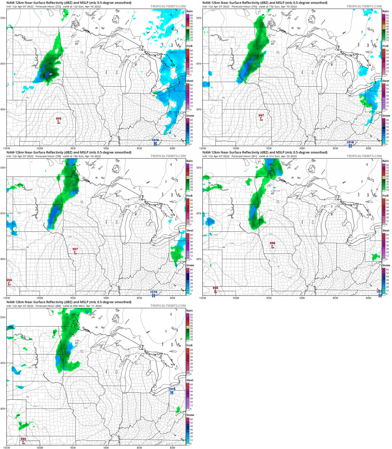
A few showers could spread into the Twin Cities metro area by Sunday evening. Check forecast updates of you have outdoor plans Sunday afternoon and evening.
Programming note
You can hear my live weather updates on MPR News at 7:35 a.m., 9:35 a.m. and 4:39 p.m. each Saturday and Sunday.

