
Weekend weather: Cold air lingers; rain-snow mix possible Sunday
Updated Minnesota snow depth map
Go Deeper.
Create an account or log in to save stories.
Like this?
Thanks for liking this story! We have added it to a list of your favorite stories.


I know, these cold temperatures are annoying.
Chilly weather will linger through this weekend. On a positive note, temperatures will rebound nicely by next Thursday and Friday and are expected to be above normal the following weekend.
Weekend temps and winds
Our average Twin Cities high temperature is 57 degrees on April 16. Metro area highs are forecast to be in the lower 40s on Saturday. That’s typical weather for mid-March — our average Twin Cities high temp is 42 degrees on March 16.
Saturday highs will be in the 30s in northern Minnesota, with 40s in the south:
Turn Up Your Support
MPR News helps you turn down the noise and build shared understanding. Turn up your support for this public resource and keep trusted journalism accessible to all.
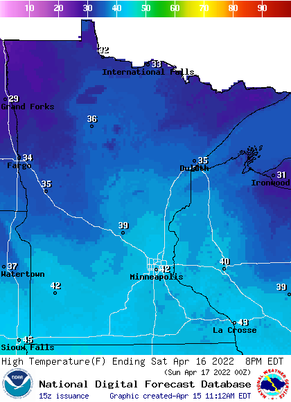
We could start out with mostly cloudy skies in the Twin Cities Saturday morning, followed by afternoon sunshine.
Saturday afternoon wind gusts will be over 20 mph in most areas:
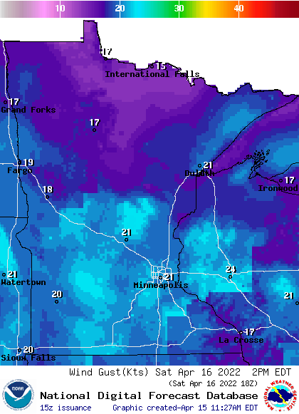
Plotted forecast gusts are in knots, with 20 knots equal to 23 mph.
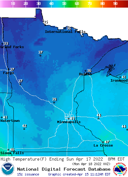
Sunday highs will be in the 30s in northern Minnesota with 40s in southern Minnesota and western Wisconsin:
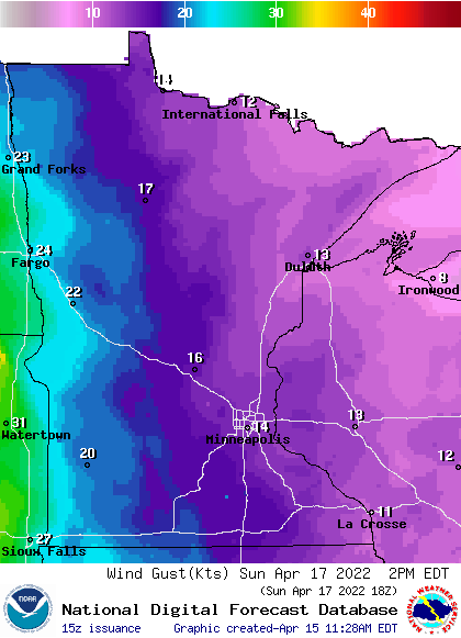
Sunday afternoon wind gusts will approach 25 mph in far western Minnesota:
Sunday rain/snow chances
A low-pressure system will spread some snow or a rain-snow mix into Minnesota and portions of western Wisconsin on Sunday.
The National Oceanic and Atmospheric Administration’s North American Mesoscale forecast model shows the potential precipitation pattern from 6 a.m. Sunday to 7 p.m. Sunday:
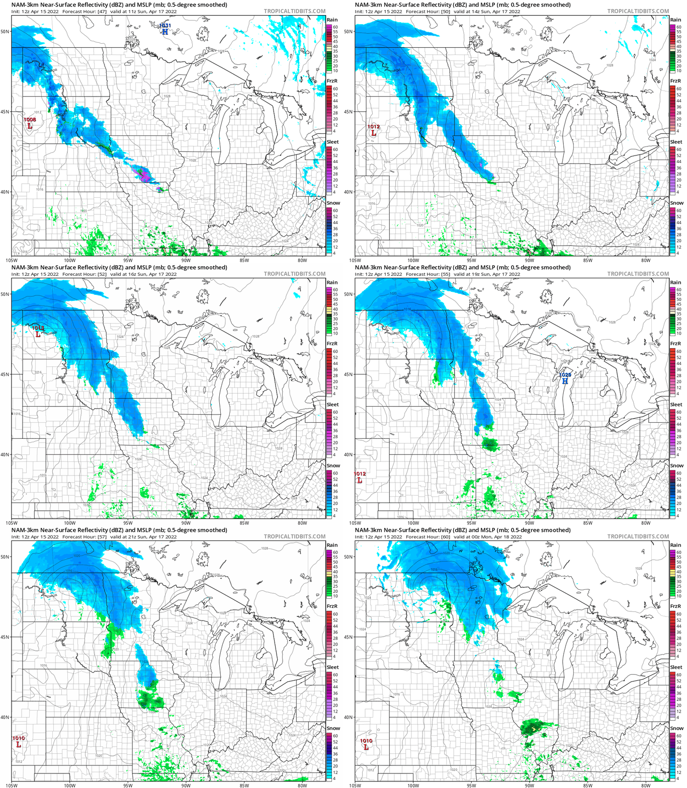
The best chance of Sunday snow accumulations appears to be in northern and central Minnesota. The Twin Cities metro area and southern Minnesota could see some snow showers, then a rain-snow mix at times.
You can hear updated weather information for Minnesota and western Wisconsin on the Minnesota Public Radio News network, and you can see updated weather info on the MPR News live weather blog.
Plenty of snow cover in NE Minnesota
If you still want to do some sledding, cross-country skiing or snowmobiling, you’ll be happy to know that there’s still plenty of snow on the ground in northeastern Minnesota and parts of north-central Minnesota.
The latest Minnesota snow depth map from the Minnesota State Climatology Office shows 12 to 18 inches of snow cover in most of Lake County and 18 to 24 inches of snow cover in much of Cook County in far northeastern Minnesota:
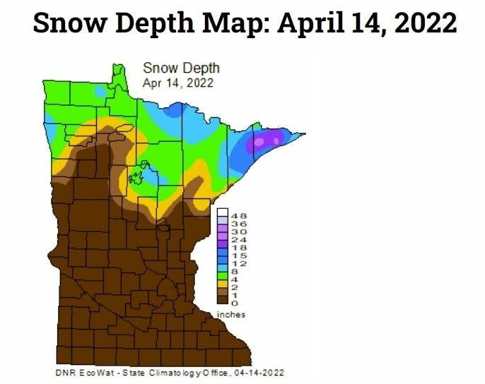
The spots that are shaded light purple in Cook County have between 24 and 30 inches of snow cover.
Programming note
You can hear my live weather updates on MPR News at 7:35 a.m., 9:35 a.m. and 4:39 p.m. each Saturday and Sunday.

