
Periods of rain, snow or a mix for much of Minnesota Sunday afternoon & evening
Heaviest snow in northern Minnesota
Go Deeper.
Create an account or log in to save stories.
Like this?
Thanks for liking this story! We have added it to a list of your favorite stories.


This feels more like March than April.
Parts of Minnesota and western Wisconsin will see periods of snow this Easter Sunday, while some areas will see rain or a mix of rain and snow. The precipitation will tend to be mostly snow in many areas Sunday night.
The National Oceanic and Atmospheric Administration’s High-Resolution Rapid-Refresh (HRRR) model shows the potential precipitation pattern from noon today to noon on Monday:
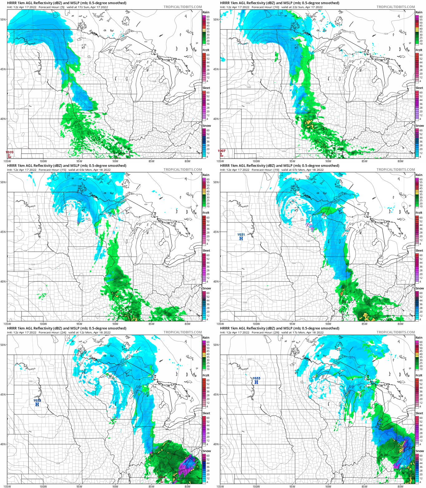
Northeastern Minnesota will see most of their snow Sunday evening into Monday morning.
Turn Up Your Support
MPR News helps you turn down the noise and build shared understanding. Turn up your support for this public resource and keep trusted journalism accessible to all.
How much snow?
The heaviest snow is expected to fall in northern Minnesota.
Here’s the snow forecast for northwestern Minnesota and eastern North Dakota:

A winter weather advisory has been issued for portions of northwestern Minnesota, with a winter storm warning in North Dakota:

Here are details of the winter weather advisory in northwestern Minnesota:
URGENT - WINTER WEATHER MESSAGE National Weather Service Grand Forks ND 339 AM CDT Sun Apr 17 2022 MNZ002-003-022-027-NDZ039-180800- /O.NEW.KFGF.WW.Y.0034.220417T1700Z-220418T0800Z/ Norman-Clay-Mahnomen-West Becker-Cass- Including the cities of Ada, Twin Valley, Halstad, Moorhead, Mahnomen, Naytahwaush, Waubun, Detroit Lakes, and Fargo 339 AM CDT Sun Apr 17 2022 ...WINTER WEATHER ADVISORY IN EFFECT FROM NOON TODAY TO 3 AM CDT MONDAY... * WHAT...Snow expected. Total snow accumulations of 1 to 3 inches. Winds gusting as high as 45 mph. * WHERE...In Minnesota, Norman, Clay, Mahnomen and West Becker Counties. In North Dakota, Cass County. * WHEN...From noon today to 3 AM CDT Monday. * IMPACTS...Plan on slippery road conditions. Areas of blowing snow could significantly reduce visibility. Gusty winds could bring down tree branches. PRECAUTIONARY/PREPAREDNESS ACTIONS... Slow down and use caution while traveling. The latest road conditions for North Dakota can be found at dot.nd.gov/travel and for Minnesota at 511mn.org, or by calling 5 1 1 in either state.
Parts of northeastern Minnesota will see heavy snow this evening into early Monday:

A winter storm warning covers southern Cook County Sunday evening into Monday afternoon, with a winter weather advisory in the remainder of Cook County and also in Lake County.
Here are details of the winter storm warning:
URGENT - WINTER WEATHER MESSAGE National Weather Service Duluth MN 248 AM CDT Sun Apr 17 2022 MNZ021-172000- /O.UPG.KDLH.WS.A.0008.220418T0000Z-220418T1800Z/ /O.NEW.KDLH.WS.W.0009.220418T0000Z-220418T2000Z/ Southern Cook- Including the city of Grand Marais 248 AM CDT Sun Apr 17 2022 ...WINTER STORM WARNING IN EFFECT FROM 7 PM THIS EVENING TO 3 PM CDT MONDAY... * WHAT...Heavy snow expected. Total snow accumulations of 5 to 7 inches. * WHERE...Southern Cook County. This includes the Tribal Lands of the Grand Portage Reservation. * WHEN...From 7 PM this evening to 3 PM CDT Monday. * IMPACTS...Travel could be very difficult. The hazardous conditions could impact the morning commute. PRECAUTIONARY/PREPAREDNESS ACTIONS... If you must travel, keep an extra flashlight, food, and water in your vehicle in case of an emergency. The latest road conditions can be obtained by calling 5 1 1. Road conditions can also be found at 511mn.org for Minnesota or 511wi.gov for Wisconsin.
The Twin Cities metro area will probably see periods of rain or a rain/snow mix from about mid-afternoon into early Sunday evening, then a rain/snow mix late Sunday evening and overnight. There could also be a bit of drizzle or freezing drizzle at times overnight. Less than one inch of snow is expected in most of the metro area through Sunday night, mainly on grassy areas, with some slush possible on streets and roads. Here’s the NWS depiction of accumulation chances:

You can hear updated weather information for Minnesota and western Wisconsin on the Minnesota Public Radio News network, and you can see updated weather info on the MPR News live weather blog.
Temperature trends
Our average Twin Cities high temperature is 57 degrees this time of year. Metro area highs will be in the low to mid 40s today. Northern and western Minnesota will have Sunday highs in the 30s, with mainly lower 40s elsewhere in Minnesota plus western Wisconsin.
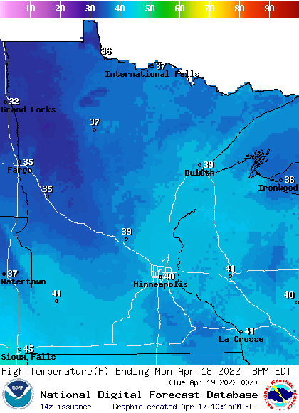
Monday highs will be in the 30s in northern Minnesota, with some lower 40s in the south and also in western Wisconsin:
Monday will be windy, with gusts over 30 mph in much of Minnesota:
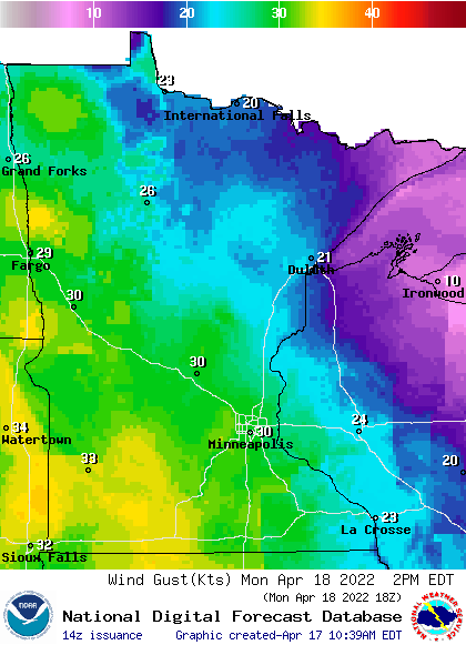
Plotted forecast gusts are in knots, with 30 knots equal to 34.5 mph.
Back to temperatures, Twin Cities metro area highs are projected to reach the mid 40s Tuesday, then lower 50s Wednesday. We could reach the upper 50s on Thursday, followed by mid 60s on Friday.
Wednesday looks like the rainiest day of the week, but we could also see some scattered showers and a few thunderstorms on Friday.
Weather nugget:
We had heavy snow on Easter Sunday in 2020, which was on April 12. MSP Airport had a final tally of 6.6 inches of fresh snow that day.
Programming note
You can hear my live weather updates on MPR News at 7:35 a.m., 9:35 a.m. and 4:39 p.m. each Saturday and Sunday.

