
A wet Saturday, with rumbles of thunder at times
Flood watches in parts of northern Minnesota
Go Deeper.
Create an account or log in to save stories.
Like this?
Thanks for liking this story! We have added it to a list of your favorite stories.


I wish I could talk about sunshine and warm temps. That’s not in the cards for our Saturday.
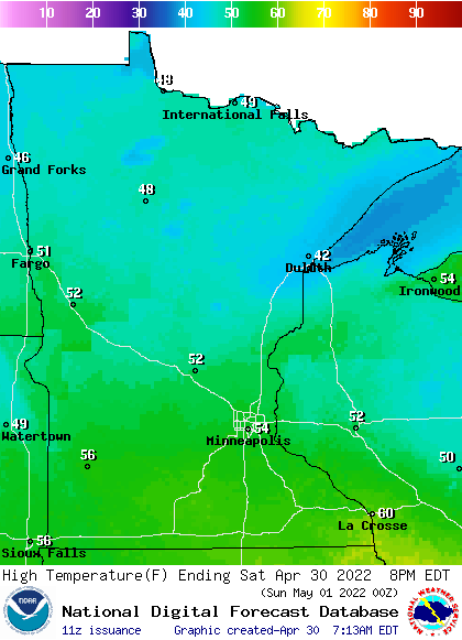
Our average Twin Cities high temperature is 63 degrees on April 30. The metro area will probably reach the mid 50s Saturday afternoon. Most of central and southern Minnesota, plus western Wisconsin, will have Saturday highs in the 50s, with 40s in northern Minnesota:
It’ll be windy today, with gusts over 30 mph at times. Even higher wind gusts can be expected near thunderstorms.
Rain and thunder
Turn Up Your Support
MPR News helps you turn down the noise and build shared understanding. Turn up your support for this public resource and keep trusted journalism accessible to all.
Periods of rain are likely across Minnesota and western Wisconsin this Saturday and Saturday night. Some thunderstorms are also possible. Rain totals Saturday through Saturday night could be between 1 to 2 inches in many areas.
Flood warnings continue along the Red River in northwestern Minnesota. Parts of northwestern Minnesota could see 2 or more inches of rain over the next 36 hours. A flood watch (dark green) continues in much of northwestern Minnesota until Sunday morning:

Here are details of the flood watch:
Flood Watch National Weather Service Grand Forks ND 416 AM CDT Sat Apr 30 2022 MNZ001>009-013>017-022>024-027-028-NDZ006>008-014>016-024-026>030- 038-039-054-011200- /O.CON.KFGF.FA.A.0002.000000T0000Z-220501T1200Z/ /00000.0.ER.000000T0000Z.000000T0000Z.000000T0000Z.OO/ West Polk-Norman-Clay-Kittson-Roseau-Lake Of The Woods- West Marshall-East Marshall-North Beltrami-Pennington-Red Lake- East Polk-North Clearwater-South Beltrami-Mahnomen- South Clearwater-Hubbard-West Becker-East Becker-Towner-Cavalier- Pembina-Benson-Ramsey-Eastern Walsh-Eddy-Nelson-Grand Forks- Griggs-Steele-Traill-Barnes-Cass-Western Walsh- Including the cities of Crookston, East Grand Forks, Ada, Twin Valley, Halstad, Moorhead, Hallock, Karlstad, Lancaster, Roseau, Warroad, Greenbush, Baudette, Warren, Stephen, Argyle, Newfolden, Middle River, Grygla, Red Lake, Redby, Ponemah, Thief River Falls, Red Lake Falls, Fosston, Fertile, McIntosh, Erskine, Bagley, Clearbrook, Bemidji, Mahnomen, Naytahwaush, Waubun, Alida, Ebro, Lake Itasca, Long Lost Lake, Lower Rice Lake, Roy Lake, Upper Rice Lake, Park Rapids, Detroit Lakes, Wolf Lake, Cando, Langdon, Cavalier, Walhalla, Drayton, Pembina, Neche, St. Thomas, Fort Totten, Maddock, Leeds, Minnewaukan, Devils Lake, Grafton, Park River, New Rockford, Lakota, Mcville, Aneta, Tolna, Grand Forks, Cooperstown, Finley, Hope, Mayville, Hillsboro, Hatton, Portland, Valley City, Fargo, Edinburg, Adams, and Lankin 416 AM CDT Sat Apr 30 2022 ...FLOOD WATCH REMAINS IN EFFECT THROUGH SUNDAY MORNING... The Flood Watch continues for * Portions of Minnesota and North Dakota, including the following areas, in Minnesota, Clay, East Becker, East Marshall, East Polk, Hubbard, Kittson, Lake Of The Woods, Mahnomen, Norman, North Beltrami, North Clearwater, Pennington, Red Lake, Roseau, South Beltrami, South Clearwater, West Becker, West Marshall, and West Polk. In North Dakota, Barnes, Benson, Cass, Cavalier, Eastern Walsh, Eddy, Grand Forks, Griggs, Nelson, Pembina, Ramsey, Steele, Towner, Traill, and Western Walsh. * Through Sunday morning * WHEN...From Friday morning through Sunday morning. * IMPACTS...Excessive runoff may result in flooding of rivers, creeks, streams, and other low-lying and flood-prone locations. Area creeks and streams are running high and could flood with more heavy rain. PRECAUTIONARY/PREPAREDNESS ACTIONS... You should monitor later forecasts and be alert for possible Flood Warnings. Those living in areas prone to flooding should be prepared to take action should flooding develop.
A flood watch starts Saturday afternoon and runs until Sunday evening along and near the North Shore of Lake Superior:

Here are details of that flood watch:
Flood Watch National Weather Service Duluth MN 231 AM CDT Sat Apr 30 2022 .Heavy rain on top of the existing snowpack may increase the rate of snowmelt. The resultant runoff may cause water levels in area rivers to increase and flooding is possible. MNZ020-021-302215- /O.NEW.KDLH.FA.A.0002.220430T2100Z-220502T0500Z/ /00000.0.RS.000000T0000Z.000000T0000Z.000000T0000Z.OO/ Southern Lake-Southern Cook- Including the cities of Two Harbors, Silver Bay, and Grand Marais 231 AM CDT Sat Apr 30 2022 ...FLOOD WATCH IN EFFECT FROM THIS AFTERNOON THROUGH SUNDAY EVENING... * WHAT...Flooding caused by rain and snowmelt is possible. * WHERE...A portion of northeast Minnesota, including the following areas, Southern Cook and Southern Lake. * WHEN...From this afternoon through Sunday evening. * IMPACTS...Excessive runoff may result in flooding of rivers, creeks, streams, and other low-lying and flood-prone locations. * ADDITIONAL DETAILS... - 1 to 2 inches of rain is expected today into Sunday, with most of the rain falling this afternoon into tonight. A continued melting snowpack will also contribute to the flooding threat. - http://www.weather.gov/safety/flood PRECAUTIONARY/PREPAREDNESS ACTIONS... You should monitor later forecasts and be alert for possible Flood Warnings. Those living in areas prone to flooding should be prepared to take action should flooding develop.
There is also a flood watch starting Saturday night for the Mississippi River at Aitkin, Minnesota:
NZ034-036-301800- /O.NEW.KDLH.FL.A.0003.220501T0600Z-000000T0000Z/ /ATKM5.0.ER.000000T0000Z.000000T0000Z.000000T0000Z.NO/ 440 AM CDT Sat Apr 30 2022 ...FLOOD WATCH IN EFFECT FROM LATE TONIGHT UNTIL FURTHER NOTICE... * WHAT...Flooding is possible. * WHERE...Mississippi River At Aitkin. * WHEN...From late tonight until further notice. * IMPACTS...At 13.0 feet, The boat ramp at Aitkin city park floods. A few driveways become covered with water in the Cedarbrook area. Minor flooding of farmland occurs in the Cedarbrook community. * ADDITIONAL DETAILS... - At 3:30 AM CDT Saturday the stage was 12.9 feet. - Forecast...Flood stage may be reached just after midnight. - Flood stage is 13.0 feet. - http://www.weather.gov/safety/flood
You can hear updated weather information for Minnesota and western Wisconsin on the Minnesota Public Radio News network, and you can see updated weather info on the MPR News live weather blog.

