
Periods of Sunday morning showers, tapering off this afternoon
Flood warnings in northwestern Minnesota
Go Deeper.
Create an account or log in to save stories.
Like this?
Thanks for liking this story! We have added it to a list of your favorite stories.


You won’t need your sunglasses today. A nearby low pressure system will continue to spin showers over much of Minnesota and Wisconsin Sunday morning.
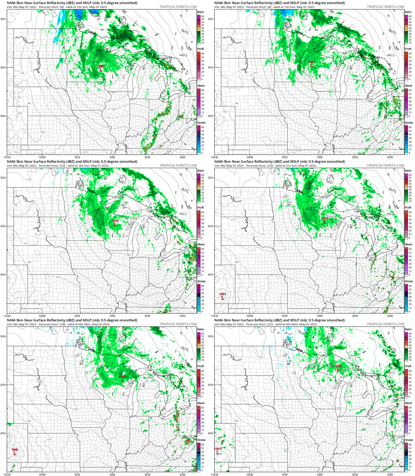
The low moves off to the northeast Sunday afternoon. The Twin Cities metro area could still see scattered showers early in the afternoon, with the best afternoon shower chances in north-central and northeastern Minnesota and northwestern and west-central Wisconsin.
The National Oceanic and Atmospheric Administration’s North American Mesoscale (NAM) forecast model shows the potential precipitation pattern from 7 a.m. to 10 p.m. Sunday:
You can hear updated weather information for Minnesota and western Wisconsin on the Minnesota Public Radio News network, and you can see updated weather info on the MPR News live weather blog.
Turn Up Your Support
MPR News helps you turn down the noise and build shared understanding. Turn up your support for this public resource and keep trusted journalism accessible to all.
Flood warnings northwestern Minnesota
Flood warnings continue along the Red River and along some smaller rivers in northwestern Minnesota. Additional portions of northwestern Minnesota (shaded light green) are under flood warnings through Sunday:

You can get flood warning details by clicking on any location at the NWS site.
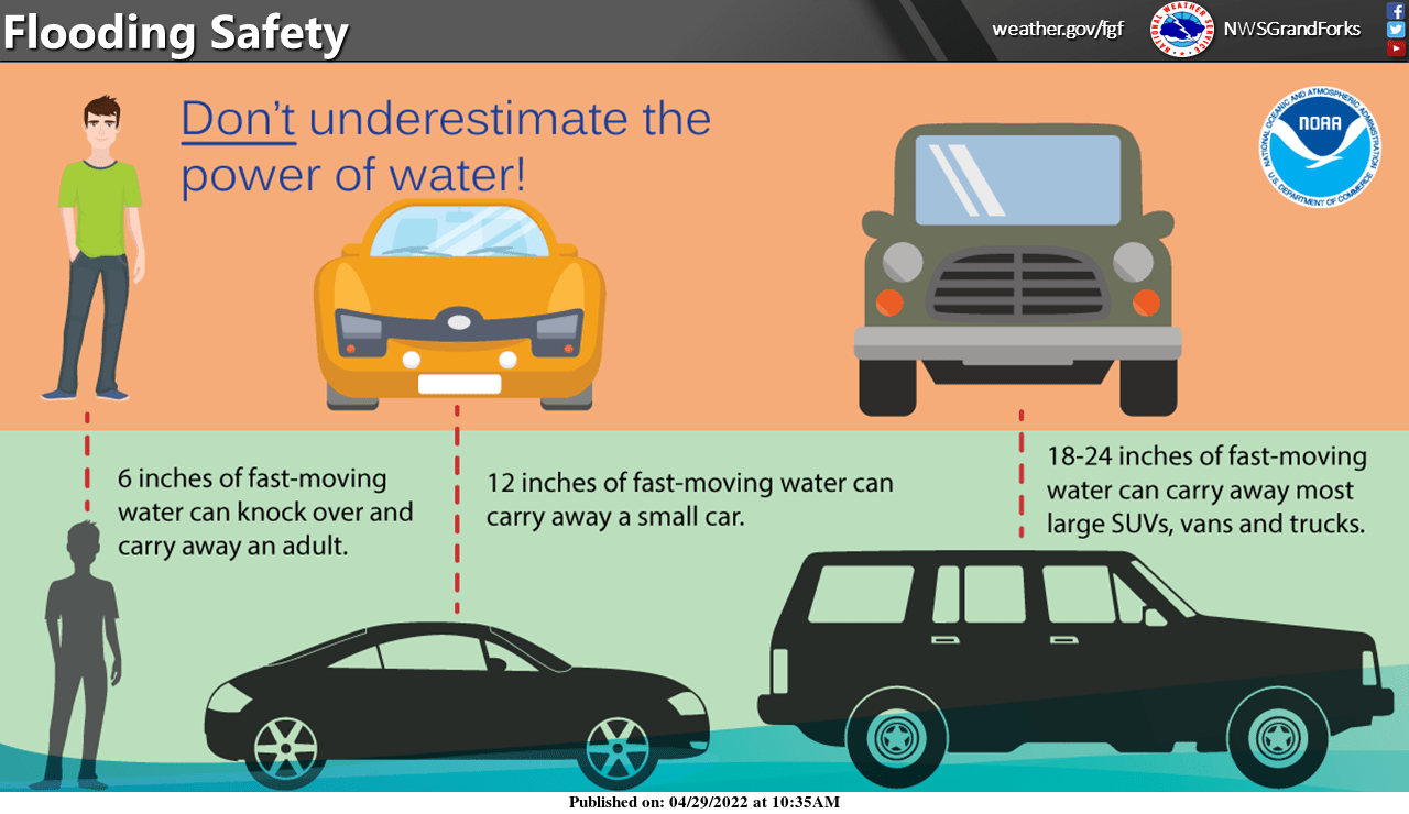
The NWS has posted these flood safety tips:
NOAA’s Advanced Hydrologic Prediction Service site shows river gauges across our region. You can click on any gauge at that site to get recent and current river levels plus the forecast levels over the next few days.
A flood watch continues through Sunday evening along and near the North Shore of Lake Superior:

Here are details of the flood watch:
National Weather Service Duluth MN 327 AM CDT Sun May 1 2022 .Rainfall amounts along the North Shore as of 3 AM range from three quarters of an inch to an inch and a half. Additional amounts today will be up to another three quarters of an inch. Also, the snowpack will continue to melt. The runoff and snowmelt may lead to flooding. Rivers have been rising overnight and they will continue to do so. MNZ020-021-012100- /O.CON.KDLH.FA.A.0002.000000T0000Z-220502T0500Z/ /00000.0.RS.000000T0000Z.000000T0000Z.000000T0000Z.OO/ Southern Lake-Southern Cook- Including the cities of Two Harbors, Silver Bay, and Grand Marais 327 AM CDT Sun May 1 2022 ...FLOOD WATCH REMAINS IN EFFECT THROUGH THIS EVENING... * WHAT...Flooding caused by rain and snowmelt continues to be possible. * WHERE...A portion of northeast Minnesota, including the following areas, Southern Cook and Southern Lake. * WHEN...Through this evening. * IMPACTS...Excessive runoff may result in flooding of rivers, creeks, streams, and other low-lying and flood-prone locations. * ADDITIONAL DETAILS... - Runoff from rainfall and continued snowmelt may cause flooding. Gauge reports so far are from three quarters of an inch to an inch and a half as of 3 am with another quarter to three quarters of inch possible today. Runoff from snowmelt will also occur. Rivers were rising and will continue to do so. - http://www.weather.gov/safety/flood PRECAUTIONARY/PREPAREDNESS ACTIONS... You should monitor later forecasts and be alert for possible Flood Warnings. Those living in areas prone to flooding should be prepared to take action should flooding develop.
Temperature trends
Much of Minnesota will have Sunday highs in the 40s. There’ll be some lower 50s from southeastern Minnesota into western Wisconsin:
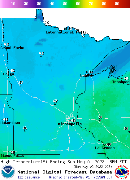
Some spots in the Twin Cities metro area will touch 50 degrees.
Sunday afternoon wind gusts could be in the 25 to 30 mph range in portions of western and south-central Minnesota:
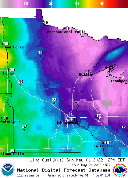
Forecast gusts are in knots, with 20 knots equal to 23 mph.
Programming note
You can hear my live weather updates on MPR News at 7:35 a.m., 9:35 a.m. and 4:39 p.m. each Saturday and Sunday.

