
Weekend shower chances in parts of Minnesota; no hot weather in sight
Update on Rainy River basin flooding
Go Deeper.
Create an account or log in to save stories.
Like this?
Thanks for liking this story! We have added it to a list of your favorite stories.


It’s June and there are many people with outdoor plans. Here’s an update on rain chances this weekend.
Saturday/Saturday evening
The best chance for periods of rain this Saturday is expected to be in southern Minnesota, especially along and south of a line from Marshall to Faribault to Wabasha and on into southern Wisconsin. There’s a chance of scattered showers a bit north of that line and into the southern edge of the Twin Cities metro area. Southern Minnesota could also see an isolated thunderstorm today.
In addition to that main area of rain in southern Minnesota, forecast models show scattered showers developing in central Minnesota later Saturday afternoon/early Saturday evening and then spreading southeastward. Some of those scattered showers could move through parts of the Twin Cities metro area this evening.
Turn Up Your Support
MPR News helps you turn down the noise and build shared understanding. Turn up your support for this public resource and keep trusted journalism accessible to all.
Sunday/Sunday evening
The National Oceanic and Atmospheric Administration’s North American Mesoscale forecast model shows the potential precipitation pattern from 5 a.m. Sunday to 11 p.m. Sunday:
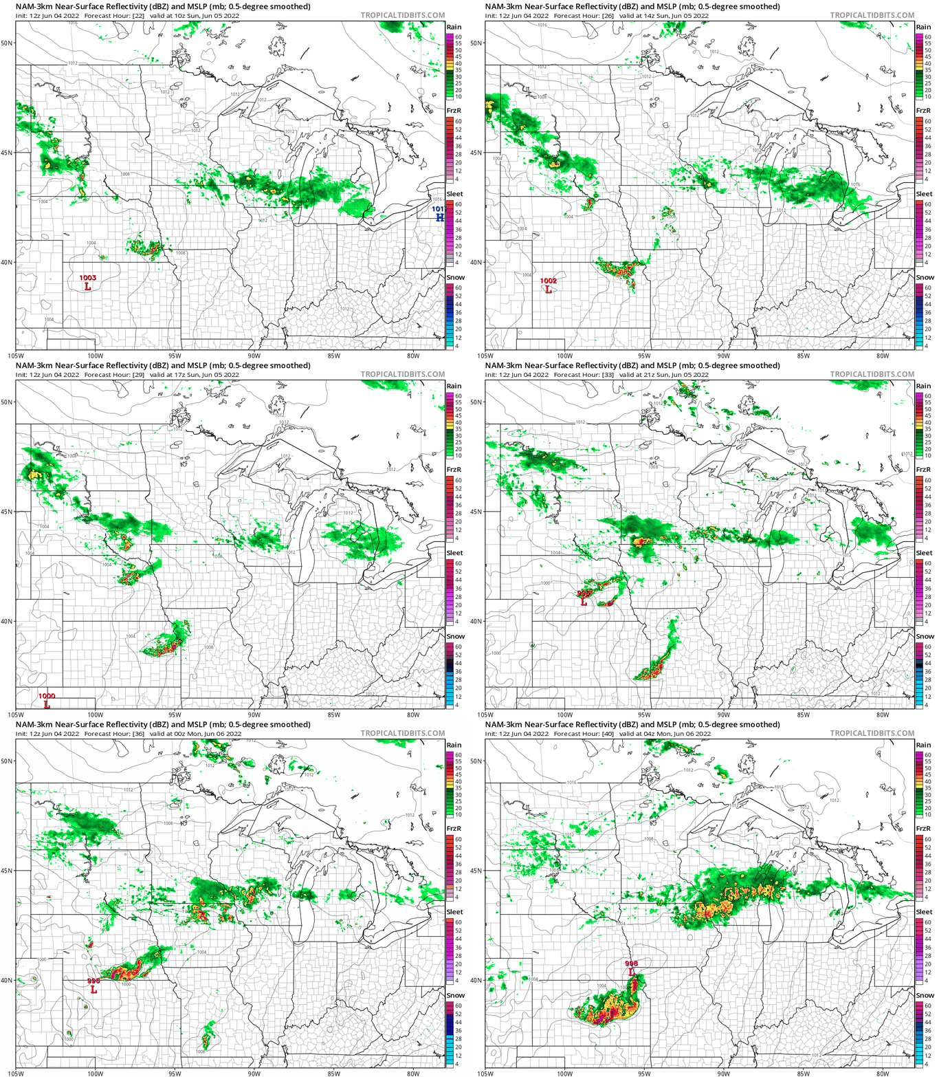
The NAM model shows the main area of Sunday rain is in far southern Minnesota, with late-day scattered showers in the far north.
NOAA’s High-Resolution Rapid-Refresh (HRRR) forecast model shows the southern Minnesota rain Sunday morning, then another batch of rain in central Minnesota by late Sunday afternoon and Sunday evening.:
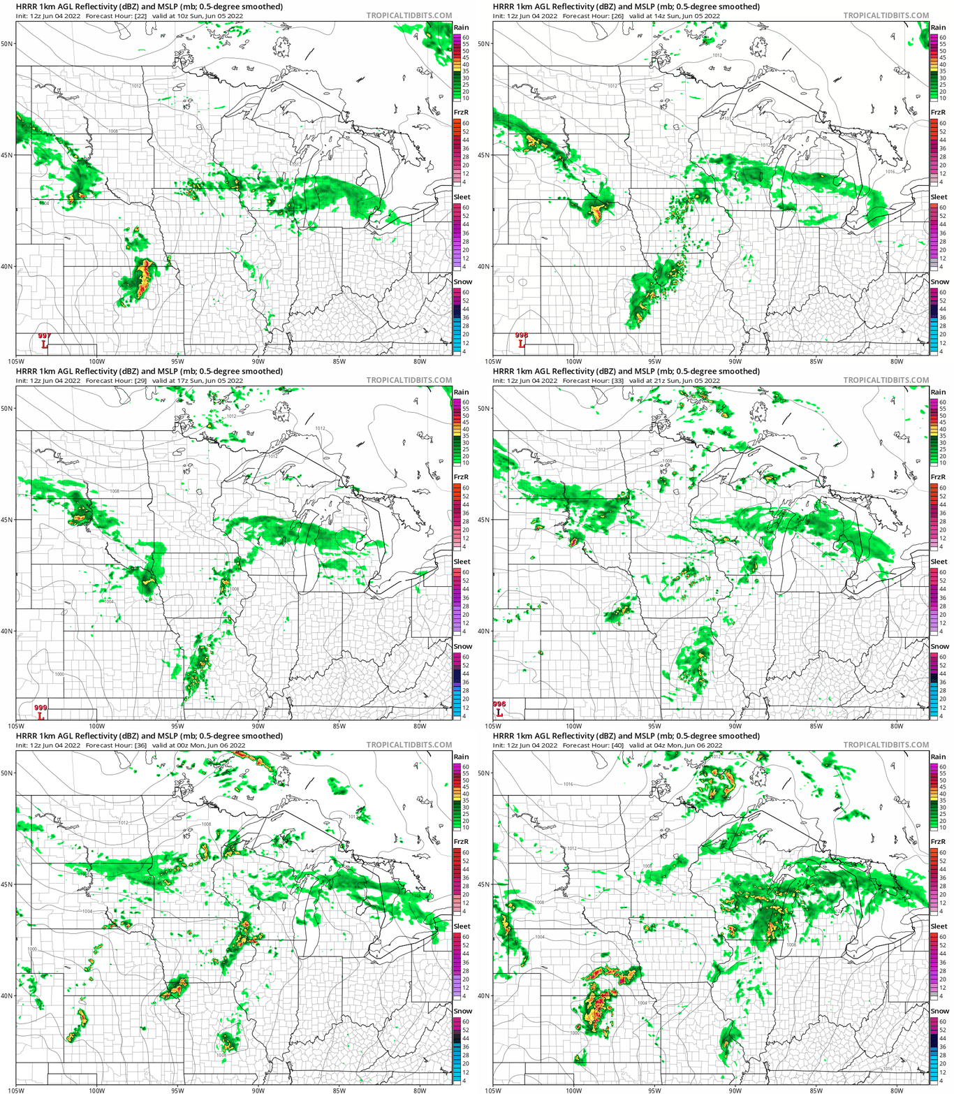
We’ll see if the forecast models come to a consensus about Sunday afternoon and evening rain chances when new runs of the models arrive later today. At this point far southern Minnesota has the best chance of rain Sunday morning, with rain chances arriving sometime Sunday afternoon into Sunday evening in some other areas.
You can hear updated weather information for Minnesota and western Wisconsin on the Minnesota Public Radio News network, and you can see updated weather info on the MPR News live weather blog.
Temperature trends
Saturday highs will be mainly in the 60s in far southern Minnesota and far northern Minnesota, with some lower 70s in between those two area. Parts of the Twin Cities metro could touch 70, but south metro highs are expected to be in the 60s. Our average Twin Cities high temp is 76 degrees this time of year.
Sunday highs will be mainly in the 60s, with a few spots topping 70:

Sunday afternoon wind gusts are expected to be in the 10 to 16 mph range in many areas, but gusts could top 20 mph in far northwestern Minnesota:

Forecast wind gusts are in knots, with 14 knots equal to 16.1 mph.
Back to temperatures, Twin Cities metro area highs are projected to be around 70 on Monday, followed by highs in the lower 70s Tuesday through Friday.
Rainy River Basin flooding update

Flood warnings continue in the Rainy River Basin of far northern Minnesota:

Here’s the most recent flood warning update for that area:
Flood Statement National Weather Service Duluth MN 408 PM CDT Fri Jun 3 2022 MNC071-137-062100- /O.CON.KDLH.FA.W.0012.000000T0000Z-220606T2100Z/ /00000.0.RS.000000T0000Z.000000T0000Z.000000T0000Z.OO/ Koochiching MN-St. Louis MN- 408 PM CDT Fri Jun 3 2022 ...FLOOD WARNING REMAINS IN EFFECT UNTIL 4 PM CDT MONDAY... * WHAT...Flooding caused by rain and snowmelt continues. Namakan and Rainy Lake have both surpassed levels set during the 2014 peak levels. * WHERE...Portions of north central Minnesota and northeast Minnesota, including the following counties, in north central Minnesota, Koochiching. In northeast Minnesota, St. Louis. * WHEN...Until 400 PM CDT Monday. * IMPACTS...Flooding of lakes, rivers, and other low-lying and flood-prone locations is imminent or occurring. Several structures are flooded and some sand bagging operations are continuing. Low-water crossings are inundated with water and may not be passable. Expect many areas of slow moving or standing water. * ADDITIONAL DETAILS... - At 355 PM CDT, Emergency management reported ongoing extensive flooding. - Mostly dry weather is expected this week, but rises will likely continue. Namakan and Kabetogama Lakes were at 1122.3 feet as of June 3, which is 22 inches above the peak level set in 2014 and 6 inches below the 1916 peak. The level of Namakan Lake is expected to fall by 2 to 3 inches between June 3 and June 10. Rainy Lake was at 1112.9 feet as of June 3 which is 19 inches above the 2014 flooding peak and matches the record peak of 1950. Rainy Lake is expected to rise by 9 to 10 inches between June 3 and June 10. A peak is unlikely before mid- June on Rainy Lake regardless of precipitation patterns. - Some locations that will experience flooding include... International Falls, Kabetogama, Crane Lake, Kabetogama Lake, Voyageurs National Park, Rainy Lake East, Rainy Lake West, northwestern Boundary Waters Canoe Area Wilderness, Ranier, Ray, Island View, Ericksburg, Johnson Lake and Sand Point Lake. - Http://www.weather.gov/safety/flood http://www.weather.gov/dlh/RainyRiverBasin PRECAUTIONARY/PREPAREDNESS ACTIONS... Turn around, don`t drown when encountering flooded roads. Most flood deaths occur in vehicles. Once levels have peaked, it will take a matter of weeks to a month for levels to decline to near normal summer levels. Additional rainfall will prolong the time it takes for levels to recede.
The Duluth NWS office reported on Friday that Rainy Lake had reached a new record height:
Here’s a summary of flooding conditions in the Rainy River Basin:

The NWS Rainy River Basin page has additional information on the flooding.
Reporter Dan Kraker and other MPR News staff compiled a detailed account of the flood woes residents of the region are facing.
Weather nugget
One year ago today, the Twin Cities high temp was 97 degrees, setting new record high for June 4. MSP airport had 9 consecutive days with highs in the 90s from June 3 through June 11 of 2021:

Programming note
You can hear my live weather updates on MPR News at 7:35 a.m., 9:35 a.m. and 4:39 p.m. each Saturday and Sunday.

