Hotter Wednesday; storms north

Near 90 south with thunderstorms in northern Minnesota
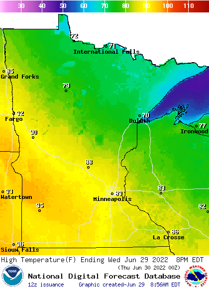
highs WED NWS
Forecast high temperatures Wednesday
National Weather Service

Temperatures are heating back up in southern and western Minnesota Wednesday. Northern Minnesota will see scattered showers and thunderstorms.

Some heat, and more humid later Wednesday

The same frontal boundary that dove south across Minnesota Tuesday is lifting back north with strong south winds Wednesday.

gusts
Forecast wind gusts midday Wednesday
National Oceanic and Atmospheric Administration, via Pivotal Weather

Many places will be near 90 in western and southern Minnesota Wednesday afternoon.

Wed highs 9am
Forecast high temperatures Wednesday
NOAA, via Pivotal Weather

Dew points will also be on the rise by the end of the day Wednesday into Thursday morning across many areas.

dews loop 9am
Forecast dew points Wednesday into Thursday
NOAA, via Pivotal Weather

Thunderstorm risk for northern Minnesota

Northern Minnesota will see scattered showers and thunderstorms Wednesday.

precip 9am
Forecast precipitation Wednesday 10 a.m. through Thursday 3 p.m.
College of DuPage

There’s a marginal risk (level 1 out of 5) of severe storms in most of those areas Wednesday though the northwestern corner of the state has a slight risk (level 2 out of 5) in the evening hours.

SPC 1
Severe weather risk Wednesday into Wednesday night
NOAA Storm Prediction Center

What’s left of those evening and overnight storms will drift across southeast Minnesota and the Twin Cities Thursday morning.

Create a More Connected Minnesota

MPR News is your trusted resource for the news you need. With your support, MPR News brings accessible, courageous journalism and authentic conversation to everyone - free of paywalls and barriers. Your gift makes a difference.