
Warm and very humid Tuesday; areas dense fog early
Go Deeper.
Create an account or log in to save stories.
Like this?
Thanks for liking this story! We have added it to a list of your favorite stories.


The muggy air from Monday condensed into widespread areas of fog early Tuesday morning. Some of the fog has become quite thick with visibilities as low as or less than a quarter of a mile. Most of the fog will break up rather quickly with heating this morning. But dense fog will be more persistent in areas affected by the chill of Lake Superior. A dense fog advisory has been posted until 11 a.m. for areas near the big lake and areas surrounding the Twin Ports.

Tuesday will remain warm and very humid. Look for afternoon high temperatures in the 70s across northern Minnesota, 80s for much of the state and low 90s in the south. The Twin Cities should have a high around 87 with a sticky dew point hovering near 70.
Thunderstorm possibilities
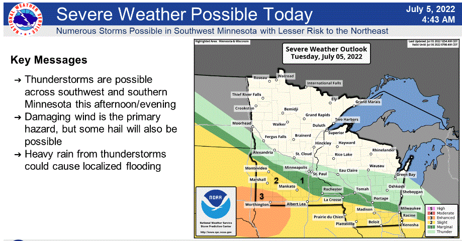
Strong to severe thunderstorms seem likely to develop over southwestern Minnesota Tuesday afternoon. That corner of the state is in an enhanced (level 3 of 5) risk of severe weather. The main risk should be damaging winds. A lesser risk of severe storms will be in the surrounding counties covered by slight and marginal risks. The Twin Cities should remain storm-free for Tuesday but might get a storm or two Tuesday night.
Cooler and drier Wednesday
A cold front will cool us off a bit and lower the dew points for Wednesday. A scattering of showers and thunderstorms could pop in the unstable air.
Rewarming toward the weekend
Warmer temperatures will head our way for the weekend. The atmosphere will remain rather unsettled all week. The best chance of possible widespread showers and storms later this week might be Saturday night or Sunday.
Turn Up Your Support
MPR News helps you turn down the noise and build shared understanding. Turn up your support for this public resource and keep trusted journalism accessible to all.

