
Thunderstorms at times Sunday and Sunday evening; Severe weather is possible
Warmer and more humid this afternoon
Go Deeper.
Create an account or log in to save stories.
Like this?
Thanks for liking this story! We have added it to a list of your favorite stories.


Temperatures and dew points will be on the rise today, providing fuel for thunderstorms.
Some thunderstorms are expected to move out of North Dakota and northeastern South Dakota this Sunday morning, spreading eastward across much of Minnesota. That batch of thunderstorms is expected to exit Minnesota early Sunday afternoon. Additional spotty thunderstorms are also possible Sunday morning ahead of the main thunderstorm area.
Thunderstorms then develop along and ahead of a cool front during the late afternoon and evening hours. The National Oceanic and Atmospheric Administration’s High-Resolution Rapid-Refresh (HRRR) forecast model shows the potential rain pattern from noon to 11 p.m. this Sunday:
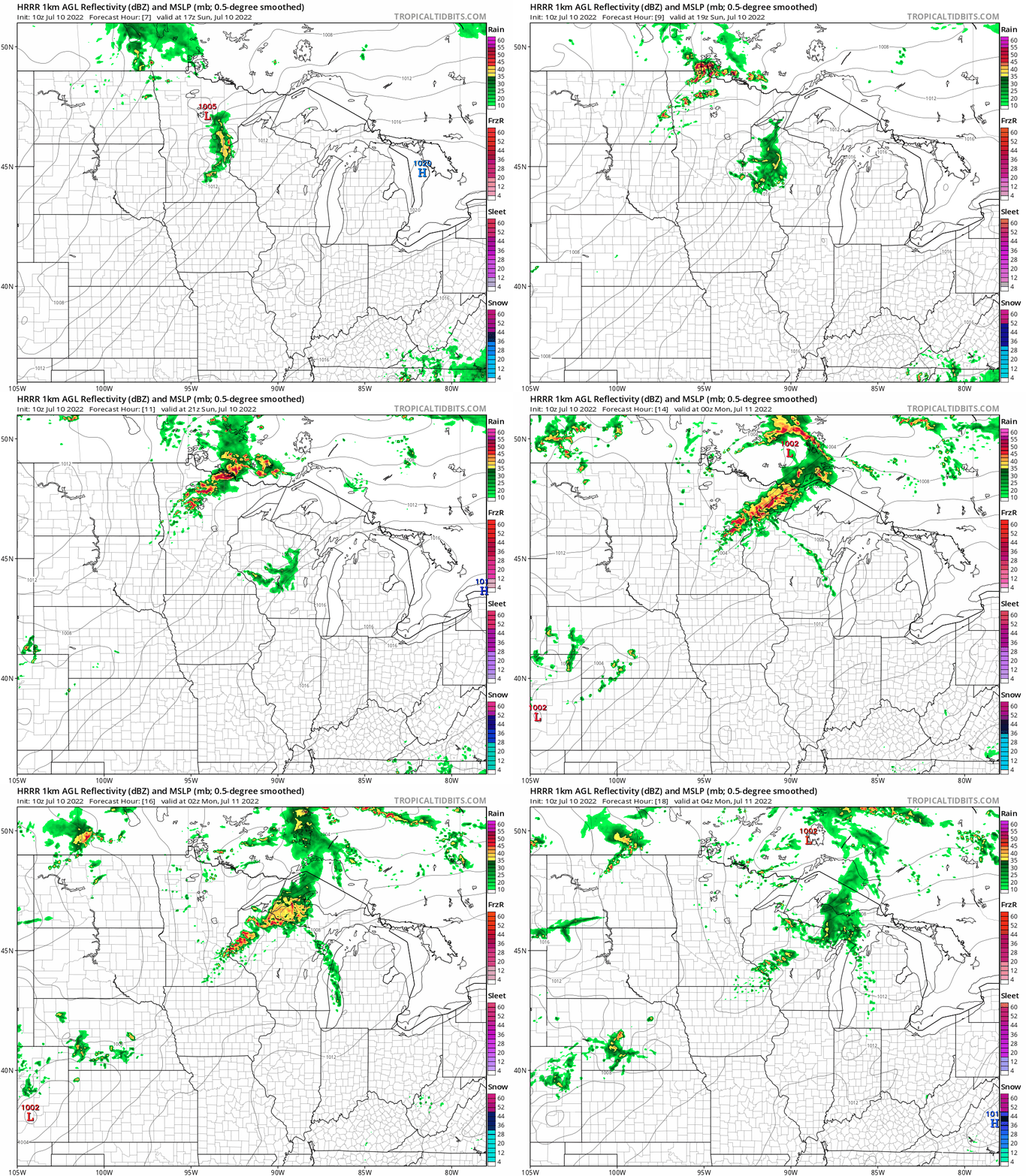
Models cannot predict every thunderstorm in a given situation, but the loop illustrates the general thunderstorm pattern that’s predicted this afternoon and evening.
Turn Up Your Support
MPR News helps you turn down the noise and build shared understanding. Turn up your support for this public resource and keep trusted journalism accessible to all.
You can hear updated weather information for Minnesota and western Wisconsin on the Minnesota Public Radio News network, and you can see updated weather info on the MPR News live weather blog.
Severe weather outlook
Updated at 8 a.m.
The NWS Storm Prediction Center has issued a severe thunderstorm watch that continues until noon today in northwestern Minnesota:
Here are details of the watch:
URGENT - IMMEDIATE BROADCAST REQUESTED Severe Thunderstorm Watch Number 455 NWS Storm Prediction Center Norman OK 745 AM CDT Sun Jul 10 2022 The NWS Storm Prediction Center has issued a * Severe Thunderstorm Watch for portions of Northern Minnesota * Effective this Sunday morning from 745 AM until NOON CDT. * Primary threats include... Scattered damaging winds and isolated significant gusts to 75 mph possible Isolated large hail events to 1.5 inches in diameter possible SUMMARY...A fast-moving cluster of storms will likely continue to be capable of wind damage and some hail through the morning as these storms move into and across parts of northern Minnesota. The severe thunderstorm watch area is approximately along and 50 statute miles east and west of a line from 30 miles northeast of Thief River Falls MN to 20 miles south southeast of Detroit Lakes MN. For a complete depiction of the watch see the associated watch outline update (WOUS64 KWNS WOU5). PRECAUTIONARY/PREPAREDNESS ACTIONS... REMEMBER...A Severe Thunderstorm Watch means conditions are favorable for severe thunderstorms in and close to the watch area. Persons in these areas should be on the lookout for threatening weather conditions and listen for later statements and possible warnings. Severe thunderstorms can and occasionally do produce tornadoes. && OTHER WATCH INFORMATION...CONTINUE...WW 454... AVIATION...A few severe thunderstorms with hail surface and aloft to 1.5 inches. Extreme turbulence and surface wind gusts to 65 knots. A few cumulonimbi with maximum tops to 550. Mean storm motion vector 27050.
______________________________________________________________________________________
10:20 a.m. Update
The NWS Storm Prediction Center has issued a severe thunderstorm watch that continues until 2 p.m. this Sunday in portions of north-central and northeastern Minnesota:
Here are details of the severe thunderstorm watch:
URGENT - IMMEDIATE BROADCAST REQUESTED Severe Thunderstorm Watch Number 456 NWS Storm Prediction Center Norman OK 1015 AM CDT Sun Jul 10 2022 The NWS Storm Prediction Center has issued a * Severe Thunderstorm Watch for portions of North central and northeast Minnesota * Effective this Sunday morning and afternoon from 1015 AM until 200 PM CDT. * Primary threats include... Scattered damaging wind gusts to 70 mph possible Isolated large hail events to 1 inch in diameter possible SUMMARY...An ongoing convective system is expected to continue eastward across northern Minnesota for the next few hours, with the threat for damaging winds of 60-70 mph and isolated large hail to near 1 inch in diameter. The severe thunderstorm watch area is approximately along and 65 statute miles east and west of a line from 20 miles east northeast of International Falls MN to 35 miles east southeast of Brainerd MN. For a complete depiction of the watch see the associated watch outline update (WOUS64 KWNS WOU6). PRECAUTIONARY/PREPAREDNESS ACTIONS... REMEMBER...A Severe Thunderstorm Watch means conditions are favorable for severe thunderstorms in and close to the watch area. Persons in these areas should be on the lookout for threatening weather conditions and listen for later statements and possible warnings. Severe thunderstorms can and occasionally do produce tornadoes. && OTHER WATCH INFORMATION...CONTINUE...WW 455... AVIATION...A few severe thunderstorms with hail surface and aloft to 1 inch. Extreme turbulence and surface wind gusts to 60 knots. A few cumulonimbi with maximum tops to 500. Mean storm motion vector 27045.
______________________________________________________________________________________
The overall severe weather outlook from the NWS Storm Prediction Center shows a slight risk (shaded yellow) of severe weather Sunday and Sunday night for much of Minnesota and parts of west-central and northwestern Wisconsin:

Notes on thunderstorm timing and impacts are from the Twin Cities NWS office.
The northern half of the Twin Cities metro area is included in that slight risk area, which indicates that scattered severe t-storms are possible. The best chance of severe weather in the Twin Cities metro area would tend to be late Sunday afternoon and Sunday evening, with an isolated severe thunderstorm possible earlier in the day.
An isolated severe thunderstorm is possible today and tonight in the darker-green shaded area that includes the south metro and southern Minnesota.
Check forecast updates and be sky aware today and this evening.
Temps and dew points
Sunday afternoon highs will be in the upper 80s to around 90 degrees across much of central and southern Minnesota:

There’ll be some low-to-mid 90s in portions of southwestern and west-central Minnesota and lower 80s in far northern Minnesota.
Dew points could top 70 degrees in parts of central and southern Minnesota Sunday afternoon:

It’ll feel steamy this afternoon.
Programming note
You can hear my live weather updates on MPR News at 7:35 a.m., 9:35 a.m. and 4:39 p.m. each Saturday and Sunday.

