Warmer Tuesday, lots of sun; rain possible Friday

Temperatures will be back above normal Tuesday and Wednesday
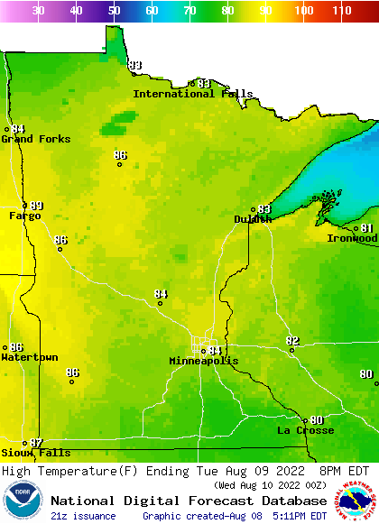
tues highs 6pm
Forecast high temperatures Tuesday
National Weather Service

Temperatures will be back above normal, with 80s spreading across most of central and southern Minnesota Tuesday and Wednesday with more sunshine. Showers and thunderstorms are possible again Friday.

Beautiful Tuesday, warmer

We’ll see a lot more 80s on the afternoon temperature map across Minnesota Tuesday. Highs will be in the low to mid-80s in the Twin Cities and mid to upper 80s in the west with 70s yet in northeast Minnesota.

Temperatures will be a bit warmer on Wednesday with upper 80s spreading into the Twin Cities.

wed highs 6pm
Forecast high temperatures Wednesday
National Weather Service

While most of us stay below 90 degrees this week, the overall temperature trend is still above normal into the weekend and early next week.

temp chart
Forecast high temperatures (blue) versus normal (orange) the next 7 days for the Twin Cities area
Meteorologist Sven Sundgaard

Friday brings the next rain chance

Scattered showers and thunderstorms again become possible late Thursday in the west and statewide Friday.

fri precip 6pm
Forecast precipitation Friday
NOAA via pivotal weather

Create a More Connected Minnesota

MPR News is your trusted resource for the news you need. With your support, MPR News brings accessible, courageous journalism and authentic conversation to everyone - free of paywalls and barriers. Your gift makes a difference.