
Saturday shower chance in some areas, quiet weather Sunday and into the start of next week
7 day rainfall totals highest to the north
Go Deeper.
Create an account or log in to save stories.
Like this?
Thanks for liking this story! We have added it to a list of your favorite stories.


Most of us will have a rain-free Saturday, but some locations could see a few minutes of rain.
A low pressure system in northeastern Iowa will drift slowly eastward today. It’s still close enough to give east-central Minnesota, the Twin Cities metro area, and parts of southern Minnesota and western Wisconsin a chance of scattered showers today, with an isolated afternoon thunderstorm also possible. The spots that do see some raindrops today will have many more dry minutes than wet minutes.
Sunday is looking rain-free in Minnesota and western Wisconsin. The beginning of next week is looking pretty dry, with rain chances increasing around midweek.
Rainfall totals the past 7 days
Turn Up Your Support
MPR News helps you turn down the noise and build shared understanding. Turn up your support for this public resource and keep trusted journalism accessible to all.
The Advanced Hydrologic Prediction Service of the National Weather Service posted the 7-day rainfall map, for the period ending at 7 a.m. today:

Parts of the Twin Cities metro area saw 2 inches or more of rain over the past week, and portions of north-central Minnesota tallied 5 inches or more of rain.
Here’s the 7-day rainfall departure from normal map:

The driest areas were in southern Minnesota and a portion of western Minnesota. Parts of northern Minnesota saw rainfall totals from 2 to 5 inches above normal over the 7 day period.
Temperature trends
Most of Minnesota and western Wisconsin will have Saturday highs in the 70s, with some 60s near Lake Superior. Dew points will be a bit sticky, in the 60s.
Sunday afternoon highs will be mainly in the 70s, but a few spots in western Minnesota could touch 80:

Metro area highs will be in the upper 70s to around 80 on Sunday. Our average Twin Cities high temp is 80 degrees this time of year.
Looking ahead, Twin Cities metro area highs are projected to reach the lower 80s Monday, Tuesday and Wednesday, then upper 70s Thursday and around 80 on Friday.
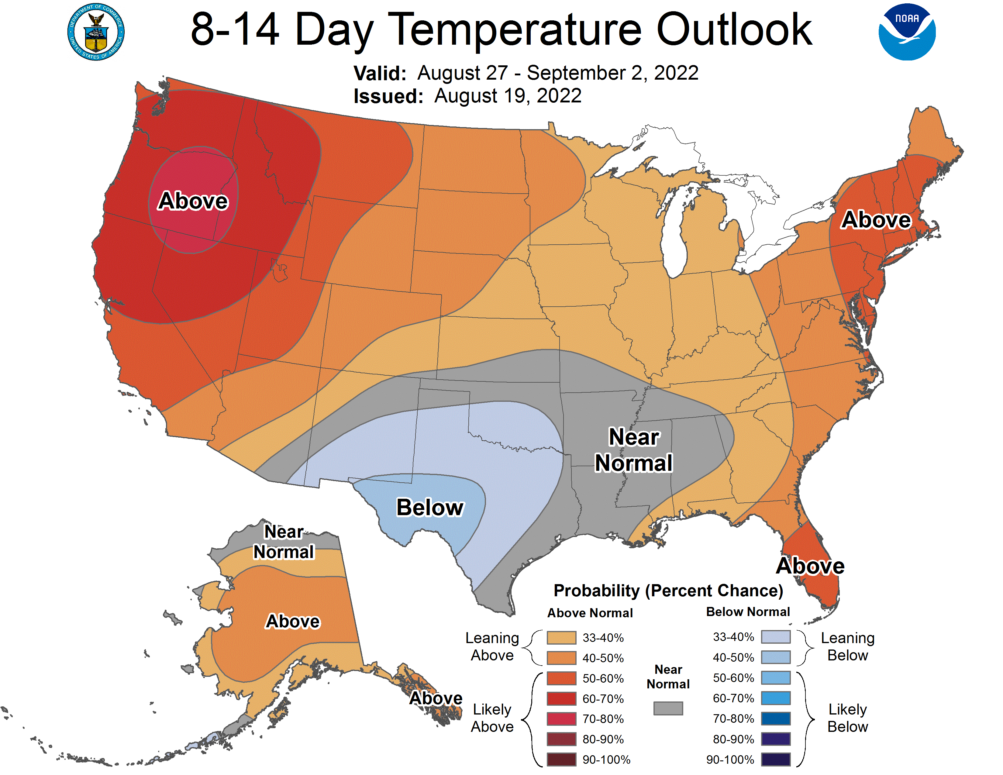
Temps next weekend and into the start off the following week could be a bit above average. The NWS Climate Prediction Center shows a tendency for above-normal temps in much of the upper Midwest from August 27 through September 2:
Weather nugget
One year ago today, our Twin Cities high temperature was 90 degrees. It was the final day of a three-day stretch of 90 degree high temps at Minneapolis-St. Paul International Airport.
Programming note
You can hear my live weather updates on MPR News at 7:35 a.m., 9:35 a.m. and 4:39 p.m. each Saturday and Sunday.

