Mild Monday night, warm Tuesday; cold later in the week

Showers will also be possible midweek
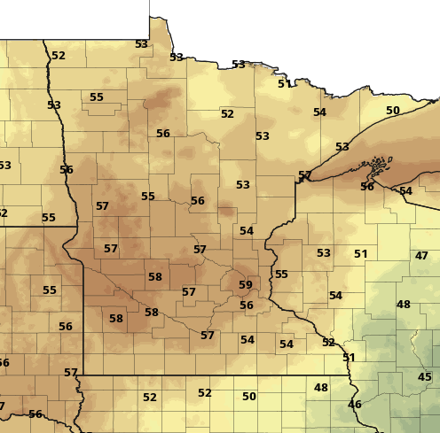
mon nt
Forecast low temperatures Monday night into early Tuesday
National Oceanic and Atmospheric Administration, via Pivotal Weather

Low temperatures Monday night will be very mild with another warm day Tuesday. Most places will be back in the 70s Tuesday but a sharp change in temperatures is coming mid to late week with showers possible Wednesday.

Warm weather continues a couple more days

Monday will be a warm overnight for early October. Lows will be mostly in the 50s — even far into northern Minnesota — to possible even 60 in the Twin Cities. Keep in mind our normal daytime highs range from 57 to 66, so we’ll be much closer to that overnight.

The blocking pattern that’s been stuck for the last several days finally will begin to break down midweek. We’ve had the remnants of Hurricane Ian to the east and a stalled upper level low to our northwest.

Those two features, which are cool puddles of air aloft, allow warm air to stream north between them at Minnesota. With the pattern moving again, this will allow some pretty chilly air to dive south late in the week.

Create a More Connected Minnesota

MPR News is your trusted resource for the news you need. With your support, MPR News brings accessible, courageous journalism and authentic conversation to everyone - free of paywalls and barriers. Your gift makes a difference.

blocking pattern
An upper-level blocking pattern will finally break this week allowing cold air to spill south by Thursday
College of DuPage weather lab

First, we have another very warm day Tuesday with highs back well into the 70s across southern Minnesota.

tue high 4pm
Forecast high temperatures Tuesday
NOAA via pivotal weather

Shower chance then windy and much colder

With the atmospheric pattern flowing again, a cold front will slide across Minnesota Wednesday touching off at least some scattered rain showers.

wed precip 4pm
Forecast precipitation 4 p.m. Tuesday through Thursday 7 a.m.
College of DuPage weather lab

Winds will increase substantially late Wednesday into Thursday also, allowing cold air to move in. Highs will be mainly in the 40s Friday.

fri highs 4pm
Forecast high temperatures Friday
NOAA, via Pivotal Weather

Friday night into early Saturday could finally bring our first frost in the Twin Cities with a hard freeze for much of the rest of the region.

sat low 4pm
Forecast low temperature Friday night into early Saturday
NOAA, via Pivotal Weather